Chautauqua County, Kansas facts for kids
Quick facts for kids
Chautauqua County
|
|
|---|---|

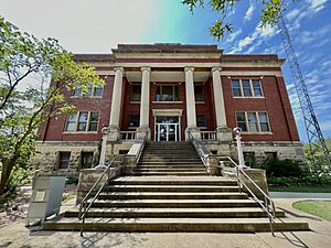
Chautauqua County Courthouse in Sedan (2023)
|
|

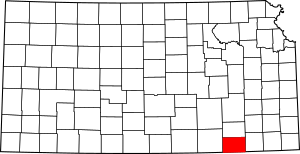
Location within the U.S. state of Kansas
|
|
 Kansas's location within the U.S. |
|
| Country | |
| State | |
| Founded | March 25, 1875 |
| Named for | Chautauqua County, New York |
| Seat | Sedan |
| Largest city | Sedan |
| Area | |
| • Total | 645 sq mi (1,670 km2) |
| • Land | 639 sq mi (1,660 km2) |
| • Water | 5.9 sq mi (15 km2) 0.9%% |
| Population
(2020)
|
|
| • Total | 3,379 |
| • Estimate
(2023)
|
3,347 |
| • Density | 5.3/sq mi (2.0/km2) |
| Time zone | UTC−6 (Central) |
| • Summer (DST) | UTC−5 (CDT) |
| Area code | 620 |
| Congressional district | 4th |
Chautauqua County is a county located in Southeast Kansas, United States. Its main town, called the county seat, is Sedan. Sedan is also the biggest city in the county. In 2020, about 3,379 people lived here. The county got its name from Chautauqua County, New York. This was because a Kansas politician named Edward Jaquins, who helped create the county, was born there.
Contents
History of Chautauqua County
Early History of the Land
For thousands of years, the Great Plains of North America were home to nomadic Native Americans. The name "Chautauqua" comes from the old Erie language, which was spoken by a Native American tribe near the Great Lakes.
From the 1500s to the 1700s, the Kingdom of France said they owned large parts of North America. But in 1762, after a big war called the French and Indian War, France secretly gave this land to Spain. This was part of a deal called the Treaty of Fontainebleau.
The 1800s and County Creation
In 1802, Spain gave most of the land back to France. Then, in 1803, the United States bought a huge area, including most of what is now Kansas, from France. This famous deal was called the Louisiana Purchase. It cost about 2.83 cents for every acre!
In 1854, the area became the Kansas Territory. Later, in 1861, Kansas officially became the 34th U.S. state. Chautauqua County was created on June 1, 1875. It was formed when Howard County was split into two parts: Elk County (the northern half) and Chautauqua County (the southern half). When it was first created, about 7,400 people lived in Chautauqua County.
Geography of Chautauqua County
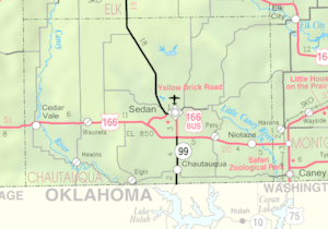
Chautauqua County covers a total area of about 645 square miles. Most of this is land (639 square miles), and a small part (about 5.9 square miles) is water.
Neighboring Counties
Chautauqua County shares its borders with these other counties:
- Elk County (to the north)
- Montgomery County (to the east)
- Washington County, Oklahoma (to the southeast)
- Osage County, Oklahoma (to the south)
- Cowley County (to the west)
Main Roads
The two main highways that go through Chautauqua County are:
- U.S. Route 166
- Kansas Highway 99
People of Chautauqua County (Demographics)
| Historical population | |||
|---|---|---|---|
| Census | Pop. | %± | |
| 1880 | 11,072 | — | |
| 1890 | 12,297 | 11.1% | |
| 1900 | 11,804 | −4.0% | |
| 1910 | 11,429 | −3.2% | |
| 1920 | 11,598 | 1.5% | |
| 1930 | 10,352 | −10.7% | |
| 1940 | 9,233 | −10.8% | |
| 1950 | 7,376 | −20.1% | |
| 1960 | 5,956 | −19.3% | |
| 1970 | 4,642 | −22.1% | |
| 1980 | 5,016 | 8.1% | |
| 1990 | 4,407 | −12.1% | |
| 2000 | 4,359 | −1.1% | |
| 2010 | 3,669 | −15.8% | |
| 2020 | 3,379 | −7.9% | |
| 2023 (est.) | 3,347 | −8.8% | |
| U.S. Decennial Census 1790-1960 1900-1990 1990-2000 2010-2020 |
|||
In 2000, there were 4,359 people living in Chautauqua County. Most people (about 93.8%) were White. About 3.6% were Native American, and smaller numbers of other groups also lived there. About 1.35% of the population was Hispanic or Latino.
The average age of people in the county in 2000 was 45 years old. About 23.4% of the population was under 18 years old, and 24.3% were 65 years or older.
Education in Chautauqua County
Kids in Chautauqua County go to schools run by different Unified school districts. These districts manage all the public schools in their area.
School Districts
- Cedar Vale USD 285
- Chautauqua County USD 286
Communities in Chautauqua County
Chautauqua County has several towns and smaller communities.
Cities
- Cedar Vale
- Chautauqua
- Elgin
- Niotaze
- Peru
- Sedan (This is the main town, or county seat)
Unincorporated Communities
These are smaller communities that are not officially organized as cities.
Ghost Towns
These are places where towns used to be, but now very few or no people live there.
- Boston
- Layton
- Leeds
- Matanzas
- Moore
- Osro
See also
 In Spanish: Condado de Chautauqua (Kansas) para niños
 | Chris Smalls |
 | Fred Hampton |
 | Ralph Abernathy |


