
Elk County, Kansas facts for kids
Quick facts for kids
Elk County
|
|
|---|---|

Elk County Courthouse in Howard (2023)
|
|

Location within the U.S. state of Kansas
|
|
 Kansas's location within the U.S. |
|
| Country | |
| State | |
| Founded | March 25, 1875 |
| Named for | Elk River |
| Seat | Howard |
| Largest city | Howard |
| Area | |
| • Total | 650 sq mi (1,700 km2) |
| • Land | 644 sq mi (1,670 km2) |
| • Water | 6.2 sq mi (16 km2) 1.0%% |
| Population
(2020)
|
|
| • Total | 2,483 |
| • Estimate
(2023)
|
2,467 |
| • Density | 3.9/sq mi (1.5/km2) |
| Time zone | UTC−6 (Central) |
| • Summer (DST) | UTC−5 (CDT) |
| Area code | 620 |
| Congressional district | 4th |
Elk County is a county located in the state of Kansas in the United States. Its main city and county seat (where the county government is) is Howard. In 2020, about 2,483 people lived in Elk County. The county got its name from the nearby Elk River.
Contents
A Look Back: Elk County's Story
How Did Elk County Begin?
For thousands of years, the Great Plains of North America were home to nomadic Native American tribes. These groups moved around to hunt and find food.
From the 1500s to the 1700s, France claimed a large part of North America. In 1762, after a big war called the French and Indian War, France secretly gave this land to Spain. This was part of a deal called the Treaty of Fontainebleau.
The 1800s: New Lands and New Borders
In 1802, Spain gave most of the land back to France. Then, in 1803, the United States bought a huge area of land from France. This was called the Louisiana Purchase. Most of what is now Kansas was part of this purchase. The U.S. paid about 2.83 cents per acre for this land.
In 1854, the U.S. created the Kansas Territory. This area was first used to relocate Native American tribes from the eastern U.S. In 1861, Kansas officially became the 34th U.S. state.
The land that is now Elk County was once a hunting ground for the Osage Indians. They hunted buffalo and other animals here. In 1867, a larger area called Howard County was formed. This included both present-day Elk County and Chautauqua County.
However, there were disagreements about where the county seat should be. Because of these disputes, the area was divided. In 1875, Elk County was officially created. It was named after the Elk River.
The first railroad in Elk County was built in 1879. This railroad helped connect local cattle ranches and farms to markets in the eastern United States.
Elk County's Location and Landscape
According to the U.S. Census Bureau, Elk County covers about 650 square miles. Most of this area, about 644 square miles, is land. The remaining 6.2 square miles, which is about 1% of the total area, is water.
Neighboring Counties
Elk County shares its borders with several other counties:
- Greenwood County (to the north)
- Wilson County (to the east)
- Montgomery County (to the southeast)
- Chautauqua County (to the south)
- Cowley County (to the southwest)
- Butler County (to the northwest)
Who Lives in Elk County?

| Historical population | |||
|---|---|---|---|
| Census | Pop. | %± | |
| 1880 | 10,623 | — | |
| 1890 | 12,216 | 15.0% | |
| 1900 | 11,443 | −6.3% | |
| 1910 | 10,128 | −11.5% | |
| 1920 | 9,034 | −10.8% | |
| 1930 | 9,210 | 1.9% | |
| 1940 | 8,180 | −11.2% | |
| 1950 | 6,679 | −18.3% | |
| 1960 | 5,048 | −24.4% | |
| 1970 | 3,858 | −23.6% | |
| 1980 | 3,918 | 1.6% | |
| 1990 | 3,327 | −15.1% | |
| 2000 | 3,261 | −2.0% | |
| 2010 | 2,882 | −11.6% | |
| 2020 | 2,483 | −13.8% | |
| 2023 (est.) | 2,467 | −14.4% | |
| U.S. Decennial Census 1790-1960 1900-1990 1990-2000 2010-2020 |
|||
In 2000, there were 3,261 people living in Elk County. These people formed 1,412 households, and 923 of these were families. The county had about 5 people per square mile. There were also 1,860 housing units, with about 3 units per square mile.
Most people in the county (95.06%) were White. Other groups included Black or African American (0.21%), Native American (0.95%), and Asian (0.18%). About 2.33% of people were from two or more races. People of Hispanic or Latino background made up 2.18% of the population.
Out of all households, 24.40% had children under 18 living with them. About 56.00% were married couples living together. Around 32.90% of households were made up of individuals living alone. Of these, 18.60% were people aged 65 or older living by themselves. The average household had 2.25 people, and the average family had 2.84 people.
The population was spread out by age. About 22.50% were under 18 years old. People aged 65 or older made up 25.30% of the population. The average age in the county was 46 years. For every 100 females, there were about 91.50 males.
The average income for a household in the county was $27,267. For families, the average income was $34,148. About 13.80% of the population lived below the poverty line. This included 18.80% of those under 18 and 15.00% of those aged 65 or over.
Education in Elk County
Students in Elk County attend schools in two main public school districts:
- West Elk USD 282
- Elk Valley USD 283
Communities of Elk County

Elk County has several cities and smaller communities.
Cities in Elk County
Unincorporated Communities
These are smaller communities that are not officially cities:
Ghost Towns
These are places that were once communities but are now abandoned:
Townships in Elk County
Elk County is divided into ten areas called townships. The population numbers for these townships include the people living in any cities within them.
| Township | FIPS | Population center |
Population | Population density /km2 (/sq mi) |
Land area km2 (sq mi) |
Water area km2 (sq mi) |
Water % | Geographic coordinates |
|---|---|---|---|---|---|---|---|---|
| Elk Falls | 20325 | 196 | 1 (3) | 152 (59) | 0 (0) | 0.19% | 37°22′17″N 96°12′26″W / 37.37139°N 96.20722°W | |
| Greenfield | 28550 | 321 | 2 (5) | 171 (66) | 1 (0) | 0.62% | 37°21′8″N 96°27′5″W / 37.35222°N 96.45139°W | |
| Howard | 33275 | Howard | 1,006 | 6 (16) | 166 (64) | 1 (1) | 0.86% | 37°28′3″N 96°15′14″W / 37.46750°N 96.25389°W |
| Liberty | 40025 | 117 | 1 (2) | 154 (59) | 0 (0) | 0.19% | 37°34′22″N 96°1′55″W / 37.57278°N 96.03194°W | |
| Longton | 42675 | 530 | 5 (12) | 116 (45) | 0 (0) | 0.11% | 37°22′38″N 96°5′27″W / 37.37722°N 96.09083°W | |
| Oak Valley | 51950 | 154 | 1 (3) | 116 (45) | 0 (0) | 0.24% | 37°21′59″N 96°1′14″W / 37.36639°N 96.02056°W | |
| Painterhood | 54075 | 68 | 0 (1) | 154 (59) | 1 (0) | 0.37% | 37°27′35″N 96°2′37″W / 37.45972°N 96.04361°W | |
| Paw Paw | 54925 | 116 | 1 (2) | 141 (54) | 0 (0) | 0.24% | 37°33′19″N 96°13′46″W / 37.55528°N 96.22944°W | |
| Union Center | 72500 | 116 | 0 (1) | 371 (143) | 2 (1) | 0.46% | 37°31′44″N 96°23′31″W / 37.52889°N 96.39194°W | |
| Wildcat | 79150 | 637 | 5 (12) | 135 (52) | 2 (1) | 1.35% | 37°21′33″N 96°19′10″W / 37.35917°N 96.31944°W | |
| Sources: | ||||||||
Images for kids
-
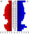
A population pyramid showing age groups in Elk County based on 2000 census data.
-
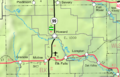
A 2005 map of Elk County.
See also
 In Spanish: Condado de Elk (Kansas) para niños
