
Greenwood County, Kansas facts for kids
Quick facts for kids
Greenwood County
|
|
|---|---|

AT&SF Railroad Depot in Eureka (2013)
|
|

Location within the U.S. state of Kansas
|
|
 Kansas's location within the U.S. |
|
| Country | |
| State | |
| Founded | August 25, 1855 |
| Named for | Alfred B. Greenwood |
| Seat | Eureka |
| Largest city | Eureka |
| Area | |
| • Total | 1,153 sq mi (2,990 km2) |
| • Land | 1,143 sq mi (2,960 km2) |
| • Water | 9.3 sq mi (24 km2) 0.8%% |
| Population
(2020)
|
|
| • Total | 6,016 |
| • Density | 5.3/sq mi (2.0/km2) |
| Time zone | UTC−6 (Central) |
| • Summer (DST) | UTC−5 (CDT) |
| Congressional district | 4th |
Greenwood County is a county in the southeast part of Kansas. Its main city and county seat is Eureka. In 2020, about 6,016 people lived here. The county got its name from Alfred B. Greenwood. He was a U.S. congressman from Arkansas who supported Kansas becoming a state.
Contents
History of Greenwood County
Early Days
For thousands of years, the Great Plains of North America were home to nomadic Native American tribes. These groups moved around to hunt and gather food.
From the 1500s to the 1700s, France claimed a large area of North America. This included the land that is now Kansas. In 1762, after a war, France secretly gave this land to Spain.
Becoming Part of the United States
In 1802, Spain gave most of the land back to France. Then, in 1803, the United States bought a huge area from France. This was called the Louisiana Purchase. It included most of what is now Kansas. The U.S. paid a very small amount for this vast land.
In 1854, the Kansas Territory was set up. Later, in 1861, Kansas officially became the 34th U.S. state. Greenwood County was created in 1855. It was named after Alfred B. Greenwood, a congressman who helped Kansas become a state. The first railroad in Greenwood County was built in 1879.
Geography
Greenwood County covers about 1,153 square miles. Most of this area is land, about 1,143 square miles. The rest, about 9.3 square miles, is water. This makes it the fifth-largest county in Kansas by size.
Neighboring Counties
Greenwood County shares borders with several other counties:
- Lyon County (north)
- Coffey County (northeast)
- Woodson County (east)
- Wilson County (southeast)
- Elk County (south)
- Butler County (west)
- Chase County (northwest)
Population and People
The number of people living in Greenwood County has changed over time. In 1860, there were 769 people. By 1930, the population grew to over 19,000. However, since then, the population has slowly decreased. In 2020, about 6,016 people lived in the county.
Most people in Greenwood County are White. A small number are Native American, Black, or Asian. Some people are of Hispanic or Latino background.
The county has many families living together. About 27% of households have children under 18. Many households are made up of married couples. The average household has about 2 to 3 people.
The population includes people of all ages. About 23% are under 18 years old. About 22% are 65 years or older. The average age in the county is around 43 years old.
Education
Greenwood County has several school districts. These districts help manage the public schools in the area.
School Districts in Greenwood County
- Madison–Virgil USD 386
- Eureka USD 389
- Hamilton USD 390
School Districts Serving Parts of Greenwood County
Some parts of Greenwood County are served by school districts based in neighboring counties:
- West Elk USD 282 (serves Severy and southern Greenwood County)
- Fredonia USD 484 (serves Fall River and the southeastern corner of Greenwood County)
Communities

Greenwood County has several cities and smaller communities.
Cities
Unincorporated Communities
These are smaller communities that are not officially cities. Some are called Census-Designated Places (CDP) by the U.S. Census Bureau.
Ghost Towns
These are places where communities once existed but are now mostly abandoned.
- Ivanpah
- Lapland
- Teterville
- Thrall
- Utopia
Images for kids
-
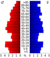
Population pyramid based on 2000 census age data

See also
 In Spanish: Condado de Greenwood (Kansas) para niños
