
Teterville, Kansas facts for kids
Quick facts for kids
Teterville, Kansas
|
|
|---|---|

|
|

Teterville, Kansas
Location in Kansas

Teterville, Kansas
Location in the United States
|
|
| Country | United States |
| State | Kansas |
| County | Greenwood |
| Elevation | 1,608 ft (490 m) |
| Population | |
| • Total | 0 |
| Time zone | UTC-6 (CST) |
| • Summer (DST) | UTC-5 (CDT) |
| Area code | 620 |
| FIPS code | 20-70275 |
| GNIS ID | 484837 |
Teterville is a ghost town located in Greenwood County, Kansas, United States. A ghost town is a place where most or all people have left, and few or no buildings are left standing. Teterville is about 11 miles east of a town called Cassoday. Today, you won't find any buildings there.
Contents
How Teterville Began
Teterville started as an "oil town" around 1920. This happened after the Teeter Oil Field was found nearby. The oil field got its name from James Teter. He owned a lot of land, about 6,900 acres, in Greenwood County.
A post office opened in Teterville in 1927. It helped people send and receive mail for many years. The post office stayed open until 1962, when it finally closed down.
Exploring Teter Rock
One interesting spot near Teterville is Teter Rock. It stands on top of a hill. You can find it about 0.9 miles (1.4 km) south of Teterhill Road. The exact location is 38°1′46.5″N 96°25′24.9″W / 38.029583°N 96.423583°W.
The History of Teter Rock
The first landmark at this spot was built in the 1870s or 1880s. It was created by James Wesley Teter. In 1954, the Greenwood County Historical Society put up the monument you see today. This new monument replaced the older one.
Visiting Teter Rock
You can visit Teter Rock. It is on private land, but there is a rural road that the public can use. When you visit, please be sure to respect the private property.
Images for kids
-
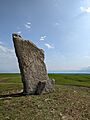
Teter Rock, near the townsite of Teterville, Greenwood County, Kansas, USA

