
Wilson County, Kansas facts for kids
Quick facts for kids
Wilson County
|
|
|---|---|

Brown Hotel in Neodesha (2017)
|
|

Location within the U.S. state of Kansas
|
|
 Kansas's location within the U.S. |
|
| Country | |
| State | |
| Founded | 1855 |
| Named for | Hiero T. Wilson |
| Seat | Fredonia |
| Largest city | Neodesha |
| Area | |
| • Total | 575 sq mi (1,490 km2) |
| • Land | 570 sq mi (1,500 km2) |
| • Water | 4.7 sq mi (12 km2) 0.8% |
| Population
(2020)
|
|
| • Total | 8,624 |
| • Density | 15.1/sq mi (5.8/km2) |
| Time zone | UTC−6 (Central) |
| • Summer (DST) | UTC−5 (CDT) |
| Congressional district | 2nd |
Wilson County is a place in Southeast Kansas. Its main town, called the county seat, is Fredonia. In 2020, about 8,624 people lived here. The county got its name from Hiero Wilson, who was a colonel during the American Civil War.
Contents
History of Wilson County
Early Times and Land Ownership
For thousands of years, the Great Plains of North America were home to nomadic Native American groups. From the 1500s to the 1700s, France said they owned large parts of North America.
In 1762, after a war, France secretly gave New France to Spain. This was part of a deal called the Treaty of Fontainebleau.
The 1800s and County Founding
In 1802, Spain gave most of the land back to France. But Spain kept about 7,500 square miles. Then, in 1803, the United States bought most of the land that is now Kansas from France. This huge purchase was called the Louisiana Purchase. It cost about 2.83 cents per acre.
In 1854, the Kansas Territory was set up. A year later, in 1855, Wilson County was officially created. It included the land that is now Wilson County and Montgomery County.
The county was named after Colonel Hiero T. Wilson. He was a successful trader with Native Americans. He was also the first white settler in Fort Scott, Kansas. People called him "Big White Chief" because he could speak Cherokee, Creek, and Osage languages.
Geography and Location
Wilson County covers about 575 square miles. Most of this area, about 570 square miles, is land. The rest, about 4.7 square miles, is water.
Neighboring Counties
Wilson County shares borders with these other counties:
- Woodson County (to the north)
- Allen County (to the northeast)
- Neosho County (to the east)
- Montgomery County (to the south)
- Elk County (to the west)
- Greenwood County (to the northwest)
People of Wilson County
The number of people living in Wilson County has changed over time.
| Historical population | |||
|---|---|---|---|
| Census | Pop. | %± | |
| 1860 | 27 | — | |
| 1870 | 6,694 | 24,692.6% | |
| 1880 | 13,775 | 105.8% | |
| 1890 | 15,286 | 11.0% | |
| 1900 | 15,621 | 2.2% | |
| 1910 | 19,810 | 26.8% | |
| 1920 | 21,157 | 6.8% | |
| 1930 | 18,646 | −11.9% | |
| 1940 | 17,723 | −5.0% | |
| 1950 | 14,815 | −16.4% | |
| 1960 | 13,077 | −11.7% | |
| 1970 | 11,317 | −13.5% | |
| 1980 | 12,128 | 7.2% | |
| 1990 | 10,289 | −15.2% | |
| 2000 | 10,332 | 0.4% | |
| 2010 | 9,409 | −8.9% | |
| 2020 | 8,624 | −8.3% | |
| 2023 (est.) | 8,382 | −10.9% | |
| U.S. Decennial Census 1790-1960 1900-1990 1990-2000 2010-2020 |
|||
In 2000, there were 10,332 people living in the county. About 29.6% of households had children under 18. The average age of people in the county was 41 years old.
Education in Wilson County
Students in Wilson County attend schools in different unified school districts. These districts manage the public schools in their areas.
School Districts
- Altoona-Midway USD 387
- Neodesha USD 461
- Fredonia USD 484
Communities in Wilson County

Wilson County has several cities and smaller communities.
Cities
Unincorporated Communities
These are smaller communities that are not officially cities.
Townships
Wilson County is divided into fifteen smaller areas called townships. The cities of Fredonia and Neodesha are separate from these townships for census purposes.
| Township | Population | Land area km2 (sq mi) |
Water area km2 (sq mi) |
Water % | Geographic coordinates |
|---|---|---|---|---|---|
| Cedar | 701 | 93 (36) | 0 (0) | 0.11% | 37°31′21″N 95°40′14″W / 37.52250°N 95.67056°W |
| Center | 618 | 103 (40) | 0 (0) | 0.14% | 37°31′5″N 95°49′11″W / 37.51806°N 95.81972°W |
| Chetopa | 188 | 93 (36) | 0 (0) | 0.11% | 37°30′28″N 95°34′14″W / 37.50778°N 95.57056°W |
| Clifton | 414 | 93 (36) | 0 (0) | 0.53% | 37°41′56″N 95°42′23″W / 37.69889°N 95.70639°W |
| Colfax | 452 | 123 (47) | 0 (0) | 0.17% | 37°40′55″N 95°36′20″W / 37.68194°N 95.60556°W |
| Duck Creek | 103 | 93 (36) | 0 (0) | 0.23% | 37°26′14″N 95°54′58″W / 37.43722°N 95.91611°W |
| Fall River | 398 | 131 (51) | 0 (0) | 0.16% | 37°32′21″N 95°55′33″W / 37.53917°N 95.92583°W |
| Guilford | 205 | 93 (36) | 0 (0) | 0.06% | 37°36′32″N 95°43′22″W / 37.60889°N 95.72278°W |
| Neodesha | 583 | 90 (35) | 0 (0) | 0.52% | 37°25′29″N 95°40′52″W / 37.42472°N 95.68111°W |
| Newark | 226 | 92 (36) | 0 (0) | 0.18% | 37°25′30″N 95°34′56″W / 37.42500°N 95.58222°W |
| Pleasant Valley | 201 | 123 (47) | 0 (0) | 0.09% | 37°36′25″N 95°36′21″W / 37.60694°N 95.60583°W |
| Prairie | 118 | 78 (30) | 0 (0) | 0.28% | 37°36′17″N 95°49′26″W / 37.60472°N 95.82389°W |
| Talleyrand | 232 | 92 (36) | 0 (0) | 0.06% | 37°25′19″N 95°48′25″W / 37.42194°N 95.80694°W |
| Verdigris | 394 | 103 (40) | 0 (0) | 0.27% | 37°39′29″N 95°53′51″W / 37.65806°N 95.89750°W |
| Webster | 51 | 77 (30) | 0 (0) | 0.15% | 37°42′0″N 95°50′1″W / 37.70000°N 95.83361°W |
Images for kids
-
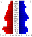
This chart shows the age groups of people in Wilson County based on the 2000 census.

See also
 In Spanish: Condado de Wilson (Kansas) para niños
