Fredonia, Kansas facts for kids
Quick facts for kids
Fredonia, Kansas
|
|
|---|---|
|
City and County seat
|
|

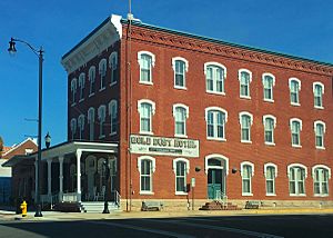
Gold Dust Hotel (2016)
|
|

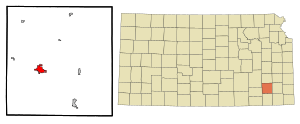
Location within Wilson County and Kansas
|
|

|
|
| Country | United States |
| State | Kansas |
| County | Wilson |
| Founded | 1860s |
| Platted | 1868 |
| Incorporated | 1871 |
| Named for | Fredonia, New York |
| Area | |
| • Total | 2.45 sq mi (6.34 km2) |
| • Land | 2.44 sq mi (6.32 km2) |
| • Water | 0.01 sq mi (0.02 km2) |
| Elevation | 896 ft (273 m) |
| Population
(2020)
|
|
| • Total | 2,151 |
| • Density | 878.0/sq mi (339.3/km2) |
| Time zone | UTC-6 (CST) |
| • Summer (DST) | UTC-5 (CDT) |
| ZIP Code |
66736
|
| Area code | 620 |
| FIPS code | 20-24575 |
| GNIS ID | 475082 |
Fredonia is a city in Kansas, United States. It is the county seat of Wilson County. In 2020, about 2,151 people lived there. The city was started in 1868. It grew a lot in the early 1900s because of a boom in fossil fuels like oil and gas.
Contents
History of Fredonia
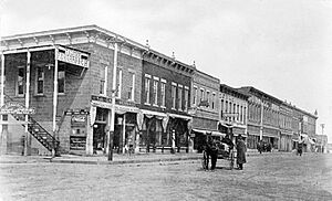
Fredonia was founded in 1868. It was built near a large hill along the St. Louis & San Francisco Railway in southeast Kansas. The city got its name from Fredonia, New York.
The very first building in Fredonia was a general store. It was built in 1868 on the town square. Soon after, a simple courthouse and a hotel were also built. The first post office opened in August 1868. The famous Gold Dust Hotel was finished in 1885.
Fredonia became a busy town with big industries. In 1913, a large amount of coal was found nearby. This coal was thought to be the best quality found in Kansas at that time. This discovery brought a lot of money to the area.
A cement plant opened in Fredonia in 1907. It provided many jobs for over 100 years before it closed in 2012. The economy also got a boost from the Archer Daniels Midland Company. This company opened a soybean processing plant in 1928. It also created many jobs for the growing town. However, this plant closed its Fredonia branch in 2003. Fredonia was once a major center for oil and natural gas.
Fredonia's Geography and Climate
Fredonia is a city with a total area of about 2.45 square miles (6.34 square kilometers). Most of this area is land. Only a small part, about 0.01 square miles (0.02 square kilometers), is water.
Fredonia's Climate Patterns
The weather in Fredonia has hot, humid summers. Winters are usually mild to cool. According to the Köppen Climate Classification system, Fredonia has a humid subtropical climate. This means it has warm temperatures and plenty of rain throughout the year.
On July 18, 1936, Fredonia recorded a very high temperature of 121 °F (49 °C). This was a record for Kansas. In 2007, Fredonia experienced major flooding. This happened in late June and early July. More than 10 inches (25 cm) of rain fell in just one night. Many people in Wilson County lost their homes because of this flood.
| Climate data for Fredonia, Kansas, 1991–2020 normals, extremes 1902–present | |||||||||||||
|---|---|---|---|---|---|---|---|---|---|---|---|---|---|
| Month | Jan | Feb | Mar | Apr | May | Jun | Jul | Aug | Sep | Oct | Nov | Dec | Year |
| Record high °F (°C) | 75 (24) |
88 (31) |
94 (34) |
98 (37) |
99 (37) |
110 (43) |
121 (49) |
116 (47) |
111 (44) |
100 (38) |
86 (30) |
79 (26) |
121 (49) |
| Mean maximum °F (°C) | 66.9 (19.4) |
69.4 (20.8) |
79.3 (26.3) |
84.4 (29.1) |
88.9 (31.6) |
93.9 (34.4) |
99.9 (37.7) |
99.4 (37.4) |
95.7 (35.4) |
86.6 (30.3) |
76.9 (24.9) |
67.2 (19.6) |
101.6 (38.7) |
| Mean daily maximum °F (°C) | 42.8 (6.0) |
48.5 (9.2) |
58.0 (14.4) |
67.8 (19.9) |
76.1 (24.5) |
85.0 (29.4) |
90.3 (32.4) |
89.6 (32.0) |
81.7 (27.6) |
70.1 (21.2) |
57.5 (14.2) |
45.6 (7.6) |
67.8 (19.9) |
| Daily mean °F (°C) | 32.3 (0.2) |
37.0 (2.8) |
46.3 (7.9) |
56.1 (13.4) |
66.0 (18.9) |
75.2 (24.0) |
79.9 (26.6) |
78.4 (25.8) |
70.2 (21.2) |
58.0 (14.4) |
46.1 (7.8) |
35.8 (2.1) |
56.8 (13.8) |
| Mean daily minimum °F (°C) | 21.5 (−5.8) |
25.5 (−3.6) |
34.6 (1.4) |
44.3 (6.8) |
55.9 (13.3) |
65.3 (18.5) |
69.4 (20.8) |
67.2 (19.6) |
58.6 (14.8) |
45.9 (7.7) |
34.7 (1.5) |
25.6 (−3.6) |
45.7 (7.6) |
| Mean minimum °F (°C) | 3.9 (−15.6) |
9.9 (−12.3) |
17.8 (−7.9) |
28.1 (−2.2) |
38.9 (3.8) |
52.5 (11.4) |
59.7 (15.4) |
55.9 (13.3) |
42.1 (5.6) |
28.2 (−2.1) |
18.8 (−7.3) |
7.5 (−13.6) |
−0.5 (−18.1) |
| Record low °F (°C) | −21 (−29) |
−15 (−26) |
−7 (−22) |
12 (−11) |
26 (−3) |
43 (6) |
47 (8) |
44 (7) |
25 (−4) |
14 (−10) |
3 (−16) |
−15 (−26) |
−21 (−29) |
| Average precipitation inches (mm) | 1.19 (30) |
1.48 (38) |
2.76 (70) |
4.31 (109) |
5.80 (147) |
6.11 (155) |
4.08 (104) |
4.15 (105) |
4.20 (107) |
3.58 (91) |
2.31 (59) |
1.80 (46) |
41.77 (1,061) |
| Average snowfall inches (cm) | 2.9 (7.4) |
0.8 (2.0) |
0.4 (1.0) |
0.1 (0.25) |
0.0 (0.0) |
0.0 (0.0) |
0.0 (0.0) |
0.0 (0.0) |
0.0 (0.0) |
0.0 (0.0) |
0.0 (0.0) |
2.3 (5.8) |
6.5 (16.45) |
| Average precipitation days (≥ 0.01 in) | 3.6 | 3.1 | 6.3 | 7.3 | 8.3 | 7.7 | 6.8 | 5.8 | 5.4 | 6.7 | 4.1 | 3.8 | 68.9 |
| Average snowy days (≥ 0.1 in) | 1.4 | 0.5 | 0.1 | 0.1 | 0.0 | 0.0 | 0.0 | 0.0 | 0.0 | 0.0 | 0.1 | 0.8 | 3.0 |
| Source 1: NOAA | |||||||||||||
| Source 2: National Weather Service | |||||||||||||
Fredonia's Population and People
| Historical population | |||
|---|---|---|---|
| Census | Pop. | %± | |
| 1880 | 923 | — | |
| 1890 | 1,515 | 64.1% | |
| 1900 | 1,650 | 8.9% | |
| 1910 | 3,040 | 84.2% | |
| 1920 | 3,954 | 30.1% | |
| 1930 | 3,446 | −12.8% | |
| 1940 | 3,524 | 2.3% | |
| 1950 | 3,257 | −7.6% | |
| 1960 | 3,233 | −0.7% | |
| 1970 | 3,080 | −4.7% | |
| 1980 | 3,047 | −1.1% | |
| 1990 | 2,599 | −14.7% | |
| 2000 | 2,600 | 0.0% | |
| 2010 | 2,482 | −4.5% | |
| 2020 | 2,151 | −13.3% | |
| U.S. Decennial Census | |||
Fredonia's 2020 Census Details
The 2020 United States census showed that 2,151 people lived in Fredonia. There were 933 households and 529 families. The population density was about 882 people per square mile. Most of the people (90.24%) were white. About 4.18% of the population was Hispanic or Latino.
About 26.8% of households had children under 18. Many households (38.0%) were married couples. Around 37.4% of households were single people living alone. The average household had 2.2 people. The average family had 2.8 people.
About 22.7% of the population was under 18 years old. Around 22.4% were 65 years or older. The average age in Fredonia was 40.8 years.
Fredonia's 2010 Census Details
In 2010, Fredonia had 2,482 people. There were 1,048 households and 630 families. The city's population density was about 1017 people per square mile. Most residents (95.4%) were White. About 3.2% of the population was Hispanic or Latino.
About 30.4% of households had children under 18. Many households (45.9%) were married couples living together. About 35.4% of all households were made up of individuals.
The median age in the city was 40.5 years. About 24.8% of residents were under 18. Around 21.8% were 65 or older.
Fredonia's Economy
Fredonia has several important employers. These businesses provide many jobs for the people living in the city.
Top Employers in Fredonia
Here are some of the biggest employers in Fredonia:
| # | Employer | # of Employees |
|---|---|---|
| 1 | A-Lert | 475 |
| 2 | Fredonia USD 484 | 157 |
| 3 | Fredonia Regional Hospital | 109 |
| 4 | Wilson County | 100 |
| 5 | Kansas Bank Note | 65 |
| 6 | Systech | 45 |
| 7 | RK Steel | 44 |
| 8 | City Of Fredonia | 41 |
| 9 | LaDow & Spohn | 33 |
Education in Fredonia
The public schools in Fredonia are part of the Fredonia USD 484 school district. The mascot for both schools in the district is the yellowjacket.
Notable People from Fredonia
Many interesting people have come from Fredonia:
- Marcus B. Bell - A brigadier general in the U.S. Army.
- George Malone (1890–1961) - He was a US Senator for Nevada. He was also a World War I veteran and a civil engineer.
- Don Myers - A member of the Kansas House of Representatives.
- Benjamin Paulen (1869–1961) - He was the 23rd Governor of Kansas.
- Charles Stokes (1902-1996) - He was a member of the Washington House of Representatives.
- Kendall Trainor (born 1967) - An All-American placekicker for the University of Arkansas football team.
See also
 In Spanish: Fredonia (Kansas) para niños
 | Shirley Ann Jackson |
 | Garett Morgan |
 | J. Ernest Wilkins Jr. |
 | Elijah McCoy |


