
Wilson, Kansas facts for kids
Quick facts for kids
Wilson, Kansas
|
|
|---|---|
.jpg)
Tobias water tower in Wilson (2024)
|
|
| Motto(s):
"Czech Capital of Kansas"
|
|

Location within Ellsworth County and Kansas
|
|

|
|
| Country | United States |
| State | Kansas |
| County | Ellsworth |
| Founded | 1871 |
| Incorporated | 1883 |
| Named for | Wilson Township |
| Government | |
| • Type | Mayor–Council |
| Area | |
| • Total | 0.60 sq mi (1.55 km2) |
| • Land | 0.60 sq mi (1.55 km2) |
| • Water | 0.00 sq mi (0.00 km2) |
| Elevation | 1,690 ft (520 m) |
| Population
(2020)
|
|
| • Total | 859 |
| • Density | 1,432/sq mi (554.2/km2) |
| Time zone | UTC-6 (CST) |
| • Summer (DST) | UTC-5 (CDT) |
| ZIP code |
67490
|
| Area code | 785 |
| FIPS code | 20-79675 |
| GNIS ID | 2397332 |
Wilson is a city in Ellsworth County, Kansas, United States. It's known as the "Czech Capital of Kansas." This is because many Czech immigrants helped build the town a long time ago. In 2020, about 859 people lived there.
Contents
History of Wilson
In 1865, a stagecoach stop was built near where Wilson is today. This was part of the Butterfield Overland Despatch route. A few years later, in 1868, the Kansas Pacific Railway built a train station called Wilson Station. It was named after the area around it, Wilson Township.
In 1871, a company planned the first town here. They called it Bosland, hoping it would become a big center for cattle trading. Settlers from Pennsylvania arrived, including some Pennsylvania Dutch families. But the town never became a cattle hub. People kept calling it Wilson, and the U.S. Post Office made that the official name in 1873.
Starting in 1874, many Czech immigrants came from Bohemia to work on the railroad. They brought their culture with them, making Wilson an important place for Czech culture in the area. Wilson officially became a city in 1883.
Where is Wilson?
Wilson is in north-central Kansas. It's about 1.5 miles (2.4 km) south of where Interstate 70 and Kansas Highway 232 meet. The city is about 95 miles (153 km) northwest of Wichita and 205 miles (330 km) west of Kansas City. It's also 15 miles (24 km) northwest of Ellsworth, which is the main town of the county.
Wilson is located in the Smoky Hills area of the Great Plains. It's about 2 miles (3.2 km) north of the Smoky Hill River and 6 miles (9.7 km) south of Wilson Lake. Wilson Creek, a smaller river that flows into the Smoky Hill, runs along the east side of the city. The city covers an area of about 0.60 square miles (1.55 square kilometers), all of which is land.
Population and People
| Historical population | |||
|---|---|---|---|
| Census | Pop. | %± | |
| 1880 | 458 | — | |
| 1890 | 770 | 68.1% | |
| 1900 | 939 | 21.9% | |
| 1910 | 981 | 4.5% | |
| 1920 | 1,020 | 4.0% | |
| 1930 | 1,038 | 1.8% | |
| 1940 | 1,068 | 2.9% | |
| 1950 | 1,039 | −2.7% | |
| 1960 | 905 | −12.9% | |
| 1970 | 870 | −3.9% | |
| 1980 | 978 | 12.4% | |
| 1990 | 834 | −14.7% | |
| 2000 | 799 | −4.2% | |
| 2010 | 781 | −2.3% | |
| 2020 | 859 | 10.0% | |
| U.S. Decennial Census | |||
As of the 2020 census, Wilson had a population of 859 people. The city's population has changed over the years, as you can see in the table.
Economy and Jobs
Many people in Wilson work in different fields. Some work in service jobs, helping customers. Others work in management, business, or science. There are also jobs in manufacturing, transportation, and construction. Many people also work in education, healthcare, and public services.
Living in Wilson is not very expensive. The cost of living is lower than the average for the United States. Homes are also more affordable here compared to many other places.
Education
Students in Wilson attend schools in the Central Plains USD 112 public school district. Wilson High School is one of two high schools in this district. The school's sports teams and mascot are called the Wilson Dragons.
Transportation and Utilities
Getting Around
Interstate 70 and U.S. Route 40 run together about 1.5 miles (2.4 km) north of Wilson. These major roads connect with K-232, which runs north and south along the east side of the city. An older part of U.S. Route 40 also goes through Wilson.
The Kansas Pacific (KP) train line, run by the Union Pacific Railroad, also passes through Wilson. It runs parallel to the old U.S. Route 40.
Services
Rolling Hills Electric Co-Op, Inc. provides electricity to Wilson. Wilson Communications offers phone, internet, and cable TV services. The city government is in charge of providing water to residents. Most homes in Wilson use natural gas for heating, which is provided by Midwest Energy.
Culture and Events
Wilson is known as the "Czech Capital of Kansas." This title was given on July 10, 1967, by Kansas Governor Robert Docking. It celebrates the many Czech immigrants who settled here in 1874. In 2012, about 14.4% of the people in Wilson said they had Czech family roots.
To honor this heritage, Wilson holds an annual After Harvest Czech Festival. It takes place on the last Saturday in July. The festival features Czech American culture, with dancers and music. There's also a carnival, a parade, sports games, talent shows, and other fun activities.
The city also celebrates other holidays with special events. There's a Halloween festival in October and a Christmas festival in December.
Famous People from Wilson
Some notable people who were born or lived in Wilson include:
- Neva Egan (1914-2011), who was the first First Lady of Alaska.
- John Kuck (1905-1986), an Olympic athlete who won a gold medal in shot put at the 1928 Summer Olympics.
Images for kids
-
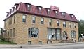
Midland Railroad Hotel (2014)
-
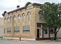
(2014)
-
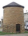
Tobias water tower (2014)
-
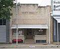
City hall (2014)
-
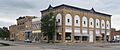
Wilson Downtown Historic District #3 (2014)
-
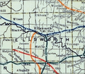
1915 Railroad Map of Ellsworth County


See also
 In Spanish: Wilson (Kansas) para niños
