Wilson Lake (Kansas) facts for kids
Quick facts for kids Wilson Lake |
|
|---|---|

Wilson Dam
|
|

|
|
| Location | Russell and Lincoln counties in Kansas |
| Coordinates | 38°56′25″N 98°33′24″W / 38.94028°N 98.55667°W |
| Type | Reservoir |
| Primary inflows | Saline River |
| Primary outflows | Saline River |
| Catchment area | 1,917 sq mi (4,970 km2) |
| Basin countries | United States |
| Managing agency | U.S. Army Corps of Engineers |
| Built | April 1961 |
| First flooded | December 29, 1964 |
| Max. length | 24 miles (39 km) |
| Surface area | 9,045 acres (36.60 km2) |
| Max. depth | 65 ft (20 m) |
| Water volume | Full: 242,528 acre⋅ft (299,154,000 m3) Current (Nov. 2015): 156,100 acre⋅ft (192,500,000 m3) |
| Shore length1 | 100 mi (160 km) |
| Surface elevation | Full: 1,516 ft (462 m) Current (May. 2019): 1,523 ft (464 m) |
| Settlements | Lucas, Sylvan Grove, Wilson |
| 1 Shore length is not a well-defined measure. | |
Wilson Lake is a large, man-made lake in Kansas, a state in the United States. It sits right on the edge of Russell County and Lincoln County.
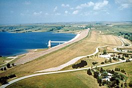
The U.S. Army Corps of Engineers built and manages this lake. Its main purpose is to help control floods. But it's also a great place for managing wildlife and for people to have fun! You can find several parks along its shores, including Wilson State Park.
Contents
Building Wilson Lake
The U.S. Army Corps of Engineers planned, designed, and built the Wilson Dam. This dam holds back the water to create Wilson Lake. They finished building it in 1964. The whole project cost about $20 million.
Where is Wilson Lake?
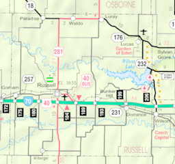
Wilson Lake is located in the middle of northern Kansas. It's part of a hilly area called the Smoky Hills region, which is within the larger Great Plains.
Most of Wilson Lake is in Russell County. A smaller part of the lake, towards its southeast side, reaches into Lincoln County. The lake is about 1,516 feet (462 m) above sea level.
The Wilson Dam and Rivers
The lake is held back by Wilson Dam at its northeast end. The dam itself is about 1,588 feet (484 m) high.
The main river that flows into Wilson Lake is the Saline River. This river enters the lake from the west. The Saline River also flows out of the lake to the east. Other smaller streams, like Elm Creek and Hell Creek, also feed water into the lake.
Roads Around the Lake
Kansas Highway 232 runs north and south along the eastern side of the lake. This highway also goes right over the top of Wilson Dam. Another paved road, called Shoreline Road, runs east and west along the southern shore of the lake. It crosses the southeastern part of the lake.
How Big is Wilson Lake?
The size of Wilson Lake can change. This depends on how much water flows into it and what the weather is like. When the lake is completely full, it covers a huge area of about 33,882 acres (137.12 km2). At its fullest, the water level is about 1,588 feet (484 m) high. The amount of water in the lake at its fullest is about 1,666,995 acre⋅ft (2.056208×10⁹ m3).
About Wilson Dam
Wilson Dam is a special kind of dam made from rock and soil. It stands about 130 feet (40 m) tall. The dam is also very long, stretching for about 5,600 feet (1,700 m).
 | Janet Taylor Pickett |
 | Synthia Saint James |
 | Howardena Pindell |
 | Faith Ringgold |

