Sylvan Grove, Kansas facts for kids
Quick facts for kids
Sylvan Grove, Kansas
|
|
|---|---|

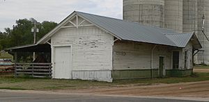
Former rail depot (2014)
|
|

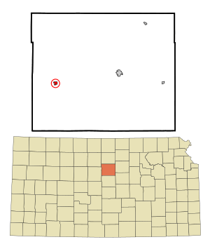
Location within Lincoln County and Kansas
|
|

|
|
| Country | United States |
| State | Kansas |
| County | Lincoln |
| Founded | 1877 |
| Incorporated | 1899 |
| Named for | sylvan groves |
| Area | |
| • Total | 0.39 sq mi (1.00 km2) |
| • Land | 0.39 sq mi (1.00 km2) |
| • Water | 0.00 sq mi (0.00 km2) |
| Elevation | 1,444 ft (440 m) |
| Population
(2020)
|
|
| • Total | 291 |
| • Density | 746/sq mi (291.0/km2) |
| Time zone | UTC-6 (CST) |
| • Summer (DST) | UTC-5 (CDT) |
| ZIP code |
67481
|
| Area code | 785 |
| FIPS code | 20-69775 |
| GNIS ID | 472542 |
Sylvan Grove is a small city located in Lincoln County, Kansas, in the United States. In 2020, about 291 people lived there. It's a quiet place with a rich history.
Contents
History of Sylvan Grove
Sylvan Grove was started in 1877. Before that, a mill was built there in 1875. The city got its name from two "sylvan" groves, which means wooded areas, located near where the town began.
Two important buildings in Sylvan Grove are listed on the National Register of Historic Places. These are the Evangelical Lutheran School and the Sylvan Grove Union Pacific Depot. Being on this list means they are special places that are important to history.
Geography and Climate
According to the United States Census Bureau, Sylvan Grove covers a total area of about 0.37 square miles (1.0 square kilometer). All of this area is land.
Understanding Sylvan Grove's Climate
The weather in Sylvan Grove usually has hot and humid summers. Winters are generally mild to cool. This type of weather is known as a humid subtropical climate. On climate maps, you might see it labeled as "Cfa."
Population and People
| Historical population | |||
|---|---|---|---|
| Census | Pop. | %± | |
| 1880 | 25 | — | |
| 1900 | 319 | — | |
| 1910 | 464 | 45.5% | |
| 1920 | 450 | −3.0% | |
| 1930 | 530 | 17.8% | |
| 1940 | 540 | 1.9% | |
| 1950 | 506 | −6.3% | |
| 1960 | 400 | −20.9% | |
| 1970 | 403 | 0.8% | |
| 1980 | 376 | −6.7% | |
| 1990 | 321 | −14.6% | |
| 2000 | 324 | 0.9% | |
| 2010 | 279 | −13.9% | |
| 2020 | 291 | 4.3% | |
| U.S. Decennial Census | |||
Population in 2010
In 2010, the city had 279 people living in 138 households. About 88 of these were families. The population density was about 754 people per square mile. Most residents, 98.6%, were White. A small number were Native American or from two or more races. About 1.1% of the population was Hispanic or Latino.
About 22.5% of households had children under 18. The average household had 2.02 people. The average age of people in Sylvan Grove was 46.9 years old.
Education in Sylvan Grove
The public schools in Sylvan Grove are part of the Sylvan–Lucas USD 299 school district.
In 1966, Sylvan Grove schools joined with schools from Hunter and Vesper. This created the Sylvan Unified schools. Later, in 2010, Sylvan Unified combined with Lucas-Luray schools. This formed the current USD 299, known as Sylvan-Lucas Unified schools. The Sylvan-Lucas Unified district is based in Sylvan Grove.
The mascot for Sylvan Grove High School was the Mustangs. After the school unifications, the Sylvan Unified and Sylvan-Lucas Unified schools kept the Mustangs as their mascot.
Sylvan Grove Public Library
The Sylvan Grove Public Library started in the fall of 1925. It was organized by a group called the Tuesday Club. The first library was located in a room above the Sylvan State Bank.
In 1938, the city took over the library. It then moved to a different room in the bank building. In 1949, people held a fundraiser to buy many new books for the library. On December 1, 1956, the library moved to its current home inside the City Hall building.
See also
 In Spanish: Sylvan Grove (Kansas) para niños
 | Bessie Coleman |
 | Spann Watson |
 | Jill E. Brown |
 | Sherman W. White |

