National Register of Historic Places listings in Lincoln County, Kansas facts for kids
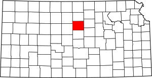
This is a list of the National Register of Historic Places listings in Lincoln County, Kansas.
This is intended to be a complete list of the properties on the National Register of Historic Places in Lincoln County, Kansas, United States. The locations of National Register properties for which the latitude and longitude coordinates are included below, may be seen in a map.
There are 15 properties listed on the National Register in the county.
Current listings
| Name on the Register | Image | Date listed | Location | City or town | Description | |
|---|---|---|---|---|---|---|
| 1 | Archeological Site Number 14LC306 |
(#82004882) |
Address restricted |
Lincoln | ||
| 2 | Bullfoot Creek Bridge |
(#85001421) |
4 miles south and 0.9 miles east of Vesper 38°58′25″N 98°15′39″W / 38.973611°N 98.260833°W |
Vesper | ||
| 3 | Cummins Block Building |
(#00000268) |
161 E. Lincoln 39°02′24″N 98°08′47″W / 39.039999°N 98.146258°W |
Lincoln | ||
| 4 | Danske Evangelist Lutheran Kirke |
(#91001154) |
Between Trail and Timber Creeks due east of Denmark 39°05′22″N 98°16′42″W / 39.089407°N 98.278351°W |
Grant Township | ||
| 5 | Evangelical Lutheran School |
(#15000690) |
308 N. Indiana St. 39°00′49″N 98°23′16″W / 39.0137°N 98.3879°W |
Sylvan Grove | ||
| 6 | Lincoln Carnegie Library |
(#87000957) |
203 S. 3rd 39°02′21″N 98°08′41″W / 39.039167°N 98.144722°W |
Lincoln | ||
| 7 | Lincoln County Courthouse |
(#76000825) |
3rd and Lincoln Ave. 39°02′27″N 98°08′41″W / 39.040833°N 98.144722°W |
Lincoln | ||
| 8 | Marshall-Yohe House |
(#01000386) |
316 S. 2nd St. 39°02′15″N 98°08′41″W / 39.037627°N 98.14472°W |
Lincoln | ||
| 9 | Nielsen Farm |
(#05001513) |
1125 E. Pike Dr. 39°05′02″N 98°17′37″W / 39.083889°N 98.293611°W |
Sylvan Grove | ||
| 10 | Salt Creek Truss Leg Bedstead Bridge |
(#03000368) |
B Rd., 0.6 mile east of its intersection with 24th Rd., 1.0 mile north of Barnard 39°12′17″N 98°02′57″W / 39.204722°N 98.049167°W |
Barnard | ||
| 11 | Spring Creek Tributary Bridge |
(#85001440) |
8 miles south and 5 miles west of Lincoln 38°54′32″N 98°14′38″W / 38.908889°N 98.243889°W |
Lincoln | ||
| 12 | Sylvan Grove Union Pacific Depot |
(#14000118) |
131 S. Main St. 39°00′34″N 98°23′34″W / 39.009449°N 98.392871°W |
Sylvan Grove | Part of the Railroad Resources of Kansas MPS |

All content from Kiddle encyclopedia articles (including the article images and facts) can be freely used under Attribution-ShareAlike license, unless stated otherwise. Cite this article:
National Register of Historic Places listings in Lincoln County, Kansas Facts for Kids. Kiddle Encyclopedia.


