
Chase County, Kansas facts for kids
Quick facts for kids
Chase County
|
|
|---|---|
Courthouse.JPG)
Chase County Courthouse in Cottonwood Falls
|
|

Location within the U.S. state of Kansas
|
|
 Kansas's location within the U.S. |
|
| Country | |
| State | |
| Founded | February 11, 1859 |
| Named for | Salmon P. Chase |
| Seat | Cottonwood Falls |
| Largest city | Cottonwood Falls |
| Area | |
| • Total | 778 sq mi (2,020 km2) |
| • Land | 773 sq mi (2,000 km2) |
| • Water | 4.7 sq mi (12 km2) 0.6%% |
| Population
(2020)
|
|
| • Total | 2,572 |
| • Density | 3.3/sq mi (1.3/km2) |
| Time zone | UTC−6 (Central) |
| • Summer (DST) | UTC−5 (CDT) |
| Area code | 620 |
| Congressional district | 2nd |
Chase County is a county in Kansas, a state in the United States. It's known for its beautiful Flint Hills region. The main city and county seat is Cottonwood Falls. In 2020, about 2,572 people lived here. The county was named after Salmon P. Chase. He was a U.S. Senator from Ohio who supported Kansas becoming a state.
Contents
History of Chase County
Early Days
For thousands of years, Native American tribes lived on the Great Plains. They moved around a lot. In the 16th to 18th centuries, France claimed much of North America. Then, in 1762, France secretly gave a huge area called New France to Spain.
In 1803, the United States bought most of what is now Kansas from France. This was part of the Louisiana Purchase. It was a huge area of land! Later, in 1848, after the Mexican–American War, more land was added. This included parts of southwest Kansas. In 1854, the Kansas Territory was formed. Kansas officially became the 34th U.S. state in 1861.
19th Century Milestones
In 1806, explorer Zebulon Pike traveled through what is now Chase County. His journey followed the Cottonwood River.
Chase County was officially created in 1859. This happened while Kansas was still a territory.
Railroads were very important for growth. In 1871, the Atchison, Topeka and Santa Fe Railway built a main line through the area. Later, in 1887, they added a branch line. This line connected many towns, including Strong City. This helped people and goods move around. In 1996, this railway became part of the BNSF Railway.
There's a unique story about the county's border. A small "notch" of land was added to Chase County from Marion County. This happened because of a murder case. Marion County didn't want to handle the trial. So, a small piece of land was given to Chase County.
20th Century Events
In 1931, Knute Rockne, a famous football coach, died in a plane crash. This happened near Bazaar in Chase County.
In 1991, Chase County became famous in a book. It was called PrairyErth: (A Deep Map). This book explored the county's history and nature.
The Tallgrass Prairie National Preserve was created in 1996. This special area helps protect the beautiful tallgrass prairie. It's a great place to learn about nature.
The exact center of population for all of Kansas is located in Chase County. It's about four miles north of Strong City.
Historical Markers to See
You can find several historical markers in Chase County. They tell important stories about the area:
- The Chase County Courthouse is a Landmark of Distinction.
- Markers explain Chase County and the Bluestem Pasture Region.
- The W. B. Strong Memorial Railroad Park also has a marker.
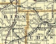
Old Maps of the Area
-
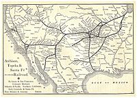
1891 Atchison, Topeka & Santa Fe Railway map.
-
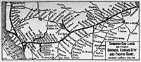
1893 Railroad Map.
-
1900-1905 Atchison, Topeka & Santa Fe Railway map.
-
1914 railroad map.
-
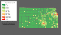
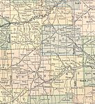
2000 Kansas population map.


Geography and Nature
Chase County covers about 778 square miles. Most of this is land, with a small part being water. It's in the eastern part of Kansas. This area is known as the Flint Hills. It's a unique region with rolling hills and tall grasses. The Neosho River also flows through the county.
Neighboring Counties
Chase County shares borders with these counties:
- Morris County (north)
- Lyon County (east)
- Greenwood County (southeast)
- Butler County (southwest)
- Marion County (west)
Protected Natural Areas
- Tallgrass Prairie National Preserve: This is a special place. It protects one of the last remaining areas of tallgrass prairie in North America.
Main Roads and Highways
Several important roads cross Chase County:
- Interstate 35: This highway runs through the county. However, it's part of the Kansas Turnpike. This means you can't usually get on or off it within the county.
- U.S. Route 50
- K-150
- K-177
Population Facts

| Historical population | |||
|---|---|---|---|
| Census | Pop. | %± | |
| 1860 | 1,046 | — | |
| 1870 | 1,975 | 88.8% | |
| 1880 | 6,081 | 207.9% | |
| 1890 | 8,233 | 35.4% | |
| 1900 | 8,246 | 0.2% | |
| 1910 | 7,527 | −8.7% | |
| 1920 | 7,144 | −5.1% | |
| 1930 | 6,952 | −2.7% | |
| 1940 | 6,345 | −8.7% | |
| 1950 | 4,831 | −23.9% | |
| 1960 | 3,921 | −18.8% | |
| 1970 | 3,408 | −13.1% | |
| 1980 | 3,309 | −2.9% | |
| 1990 | 3,021 | −8.7% | |
| 2000 | 3,030 | 0.3% | |
| 2010 | 2,790 | −7.9% | |
| 2020 | 2,572 | −7.8% | |
| 2023 (est.) | 2,579 | −7.6% | |
| U.S. Decennial Census 1790-1960 1900-1990 1990-2000 2010-2020 |
|||
Education in Chase County
Local School Districts
Most students in Chase County attend schools in the Chase County USD 284 district.
Some parts of the county are also served by school districts in neighboring counties:
- Centre USD 397
- Peabody–Burns USD 398
- Marion–Florence USD 408
Communities in Chase County

Chase County has several cities, small towns, and even some "ghost towns."
Cities to Visit
- Cedar Point
- Cottonwood Falls (This is the county seat!)
- Elmdale
- Matfield Green
- Strong City
Unincorporated Places
These are smaller communities that are not officially cities.
Ghost Towns
These are places where communities once thrived but are now mostly abandoned.
‡ means a community has parts in a nearby county.
Townships of Chase County
Chase County is divided into nine areas called townships. The population numbers for these townships include any cities located within them.
| Township | Population | Land area km2 (sq mi) |
Geographic coordinates |
|---|---|---|---|
| Bazaar | 81 | 293 (113) | 38°15′55″N 96°32′3″W / 38.26528°N 96.53417°W |
| Cedar | 116 | 142 (55) | 38°8′54″N 96°46′30″W / 38.14833°N 96.77500°W |
| Cottonwood | 184 | 209 (81) | 38°17′23″N 96°45′44″W / 38.28972°N 96.76222°W |
| Diamond Creek | 237 | 373 (144) | 38°25′31″N 96°40′35″W / 38.42528°N 96.67639°W |
| Falls | 1,163 | 131 (51) | 38°21′55″N 96°32′27″W / 38.36528°N 96.54083°W |
| Homestead | 52 | 141 (54) | 38°10′56″N 96°42′14″W / 38.18222°N 96.70389°W |
| Matfield | 155 | 316 (122) | 38°8′59″N 96°30′56″W / 38.14972°N 96.51556°W |
| Strong | 740 | 172 (67) | 38°24′20″N 96°32′18″W / 38.40556°N 96.53833°W |
| Toledo | 302 | 233 (90) | 38°24′49″N 96°23′50″W / 38.41361°N 96.39722°W |
Famous in Pop Culture
Chase County became well-known because of William Least Heat-Moon's amazing book. It's called PrairyErth: A Deep Map and was published in 1991.
Historic Places to See
Many places in Chase County are listed on the National Register of Historic Places. This means they are important and protected.
|
|
See also
 In Spanish: Condado de Chase (Kansas) para niños
