
Cottonwood Falls, Kansas facts for kids
Quick facts for kids
Cottonwood Falls, Kansas
|
|
|---|---|
|
City and County seat
|
|
Courthouse.JPG)
Chase County Courthouse designed by Kansas State Capitol architect John G. Haskell
|
|

Location within Chase County and Kansas
|
|

|
|
| Country | United States |
| State | Kansas |
| County | Chase |
| Township | Falls |
| Founded | 1859 |
| Incorporated | 1872 |
| Named for | Falls on Cottonwood River |
| Government | |
| • Type | Mayor–Council |
| Area | |
| • Total | 0.64 sq mi (1.65 km2) |
| • Land | 0.63 sq mi (1.63 km2) |
| • Water | 0.01 sq mi (0.01 km2) |
| Elevation | 1,207 ft (368 m) |
| Population
(2020)
|
|
| • Total | 851 |
| • Density | 1,330/sq mi (515.8/km2) |
| Time zone | UTC-6 (CST) |
| • Summer (DST) | UTC-5 (CDT) |
| ZIP code |
66845
|
| Area code | 620 |
| FIPS code | 20-15900 |
| GNIS ID | 477262 |
Cottonwood Falls is a small city in Kansas, United States. It is the biggest city and the main town of Chase County. In 2020, about 851 people lived there. The city is located south of Strong City, right next to the Cottonwood River.
Contents
History

Early History
For thousands of years, Native American tribes lived on the Great Plains of North America. From the 1500s to the 1700s, France claimed much of this land. In 1762, France secretly gave this land to Spain.
19th Century

In 1802, Spain gave most of the land back to France. Then, in 1803, the United States bought a huge area, including what is now Kansas, from France. This was part of the Louisiana Purchase.
In 1854, the Kansas Territory was set up. Kansas officially became the 34th U.S. state in 1861. Chase County, where Cottonwood Falls is, was created in 1859.
The first people settled in the Cottonwood Falls area in 1854. A trader named Seth Hayes started a cattle ranch by the Cottonwood River. More settlers arrived between 1856 and 1858. Cottonwood Falls became the temporary county seat when Chase County was formed.
The first post office opened in Cottonwood Falls in 1858. The beautiful Chase County Courthouse was built in 1873. Around the same time, the Atchison, Topeka and Santa Fe Railway train line reached the area. For many years, the land around the city was used for farms and cattle ranches.
20th Century
In 1931, a plane crashed about ten miles south of Cottonwood Falls. All eight people on board died. One of them was Knute Rockne, a famous football coach from the University of Notre Dame. There is a monument to this crash on private land nearby.
Cottonwood Falls has experienced many floods. In 1951, heavy rains caused rivers to overflow, flooding many cities in Kansas, including Cottonwood Falls. After this, many dams and levees were built across Kansas to help prevent future floods.
Geography

Cottonwood Falls is located at 38°22′5″N 96°32′35″W / 38.36806°N 96.54306°W. It sits in the beautiful Flint Hills area of the Great Plains. The city covers about 0.60 square miles (1.6 square kilometers). Most of this is land, with a small amount of water.
Climate
The weather in Cottonwood Falls has hot, humid summers. Winters are cool to cold. The hottest temperature ever recorded was 118°F (48°C) in July 1936. The coldest was -30°F (-34°C) in February 1905.
| Climate data for Cottonwood Falls, Kansas, 1991–2020 normals, extremes 1902–present | |||||||||||||
|---|---|---|---|---|---|---|---|---|---|---|---|---|---|
| Month | Jan | Feb | Mar | Apr | May | Jun | Jul | Aug | Sep | Oct | Nov | Dec | Year |
| Record high °F (°C) | 77 (25) |
83 (28) |
94 (34) |
96 (36) |
100 (38) |
111 (44) |
118 (48) |
114 (46) |
110 (43) |
97 (36) |
87 (31) |
80 (27) |
118 (48) |
| Mean maximum °F (°C) | 64.8 (18.2) |
70.3 (21.3) |
80.3 (26.8) |
86.3 (30.2) |
90.0 (32.2) |
94.7 (34.8) |
100.7 (38.2) |
100.0 (37.8) |
95.1 (35.1) |
87.6 (30.9) |
75.8 (24.3) |
66.1 (18.9) |
101.9 (38.8) |
| Mean daily maximum °F (°C) | 41.2 (5.1) |
46.1 (7.8) |
57.0 (13.9) |
66.8 (19.3) |
75.4 (24.1) |
84.9 (29.4) |
90.0 (32.2) |
89.0 (31.7) |
81.3 (27.4) |
69.4 (20.8) |
55.8 (13.2) |
43.9 (6.6) |
66.7 (19.3) |
| Daily mean °F (°C) | 29.5 (−1.4) |
33.8 (1.0) |
43.9 (6.6) |
54.0 (12.2) |
64.2 (17.9) |
73.8 (23.2) |
78.7 (25.9) |
77.0 (25.0) |
68.6 (20.3) |
56.1 (13.4) |
43.4 (6.3) |
32.8 (0.4) |
54.7 (12.6) |
| Mean daily minimum °F (°C) | 17.9 (−7.8) |
21.5 (−5.8) |
30.7 (−0.7) |
41.3 (5.2) |
53.0 (11.7) |
62.6 (17.0) |
67.3 (19.6) |
65.1 (18.4) |
56.0 (13.3) |
42.9 (6.1) |
30.9 (−0.6) |
21.6 (−5.8) |
42.6 (5.9) |
| Mean minimum °F (°C) | 0.4 (−17.6) |
5.0 (−15.0) |
14.1 (−9.9) |
26.2 (−3.2) |
38.6 (3.7) |
51.3 (10.7) |
57.7 (14.3) |
55.0 (12.8) |
41.0 (5.0) |
26.6 (−3.0) |
15.8 (−9.0) |
6.2 (−14.3) |
−3.8 (−19.9) |
| Record low °F (°C) | −28 (−33) |
−30 (−34) |
−8 (−22) |
10 (−12) |
22 (−6) |
40 (4) |
42 (6) |
40 (4) |
28 (−2) |
13 (−11) |
−5 (−21) |
−22 (−30) |
−30 (−34) |
| Average precipitation inches (mm) | 0.87 (22) |
1.42 (36) |
2.67 (68) |
3.54 (90) |
5.61 (142) |
4.72 (120) |
5.00 (127) |
4.37 (111) |
3.53 (90) |
2.83 (72) |
2.04 (52) |
1.39 (35) |
37.99 (965) |
| Average snowfall inches (cm) | 4.0 (10) |
1.3 (3.3) |
1.3 (3.3) |
0.2 (0.51) |
0.0 (0.0) |
0.0 (0.0) |
0.0 (0.0) |
0.0 (0.0) |
0.0 (0.0) |
0.3 (0.76) |
0.4 (1.0) |
3.1 (7.9) |
10.6 (26.77) |
| Average precipitation days (≥ 0.01 in) | 4.4 | 4.7 | 7.2 | 8.1 | 10.5 | 9.0 | 8.6 | 8.1 | 7.0 | 6.6 | 5.0 | 4.7 | 83.9 |
| Average snowy days (≥ 0.1 in) | 1.8 | 1.2 | 0.5 | 0.1 | 0.0 | 0.0 | 0.0 | 0.0 | 0.0 | 0.1 | 0.2 | 1.3 | 5.2 |
| Source 1: NOAA | |||||||||||||
| Source 2: National Weather Service | |||||||||||||
Fun Things to Do
- The Prairie Fire Festival is an event held in the area.
Cool Places to Visit
Cottonwood Falls has five places listed on the National Register of Historic Places (NRHP). This means they are important historical sites.
- Cartter Building: An old building with historical value.
- Chase County Courthouse: This is the oldest courthouse in Kansas that is still used today. It's also one of the oldest still in use west of the Mississippi River!
- Chase County National Bank: Another historic building.
- Cottonwood River Bridge: An old bridge over the Cottonwood River.
- Samuel N Wood House: The historic home of Samuel N. Wood.
- Kansas Historical Marker - A Landmark Of Distinction: A special sign in the courthouse square that tells about the area's history.
- Chase Lake Falls: A natural waterfall to explore.
Who Lives Here?
| Historical population | |||
|---|---|---|---|
| Census | Pop. | %± | |
| 1880 | 518 | — | |
| 1890 | 770 | 48.6% | |
| 1900 | 842 | 9.4% | |
| 1910 | 899 | 6.8% | |
| 1920 | 1,044 | 16.1% | |
| 1930 | 963 | −7.8% | |
| 1940 | 1,078 | 11.9% | |
| 1950 | 957 | −11.2% | |
| 1960 | 971 | 1.5% | |
| 1970 | 987 | 1.6% | |
| 1980 | 954 | −3.3% | |
| 1990 | 889 | −6.8% | |
| 2000 | 966 | 8.7% | |
| 2010 | 903 | −6.5% | |
| 2020 | 851 | −5.8% | |
| U.S. Decennial Census | |||
Cottonwood Falls is part of the Emporia area, which is a group of towns connected by their economy.
2020 Census Snapshot
In 2020, the 2020 United States census counted 851 people living in Cottonwood Falls. There were 318 households, which are groups of people living together. About 23% of households had children under 18. Many households (45%) were married couples.
The population included people of different backgrounds. About 77% were white, and about 18% were Hispanic or Latino.
The average age in the city was about 41.9 years old. About 16.5% of the people were under 18.
2010 Census Snapshot
In 2010, there were 903 people living in Cottonwood Falls. The city had 342 households. About 28.7% of these households had children under 18.
The average age of people in the city was 43.3 years. About 20.2% of the residents were under 18 years old.
Schools and Learning
Local Schools
The public schools in Cottonwood Falls are part of the Chase County USD 284 school district. There are two main schools:
- Chase County Junior/Senior High School: This school is for older students.
- Chase County Elementary School: This school is for younger students and is located in nearby Strong City, Kansas.
The sports teams at Chase County High School are called the Chase County Bulldogs.
Library
- Burnley Memorial Library: This is the local library where you can find books and learn new things.
Getting Around and Services
Transportation
- K-177 highway: This main road runs north and south through the city.
- Chase County Airport: A small airport located southeast of the city.
Utilities
- Internet: You can get internet service from companies like HughesNet, StarBand, and WildBlue using satellites.
- TV: Satellite TV is available from DirecTV and Dish Network. You can also watch free over-the-air digital TV channels.
Gallery
- Historic Images of Cottonwood Falls, Special Photo Collections at Wichita State University Library.
-
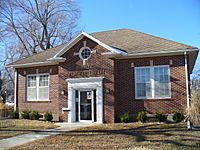
Burnley Memorial Library, 2006
-
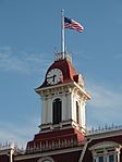
Courthouse Clock Tower, 2009
-
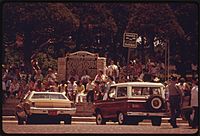
People gather in the town square during a parade in June 1974


Famous People from Cottonwood Falls
- Dudley Doolittle (1881-1957): He was a lawyer, banker, and served as a U.S. Representative for Kansas.
- Harley Martin (1880-1951): He was a farmer and a state legislator in Wisconsin.
- William Morgan (1866-1932): He was a newspaper publisher, writer, and served as the lieutenant governor of Kansas.
- Samuel Wood (1825-1891): He was a lawyer and a politician in Kansas.
Cottonwood Falls in Movies and Books
- In the 1985 Disney movie Return to Oz, a doctor's clinic is set near Cottonwood Falls.
- In the 2005 movie Jarhead, one of the characters, PFC Fergus O'Donnell, is from Cottonwood.
- An episode of the TV show The Blacklist (season 8, episode 13, "Anne") was set and partly filmed in Cottonwood Falls.
- In the book The Mighty Mogul from the Great Railway Adventures series, Cottonwood Falls is a stop for a train looking for supplies to build a new school.
See also
 In Spanish: Cottonwood Falls (Kansas) para niños
