
Cottonwood River (Kansas) facts for kids
Quick facts for kids Cottonwood River |
|
|---|---|

1886 Clements Stone Arch Bridge over Cottonwood River near Clements (2006)
|
|
| Country | United States |
| State | Kansas |
| Region | Flint Hills |
| Physical characteristics | |
| Main source | West of Marion, Kansas 1,056 ft (322 m) 38°21′25″N 097°04′14″W / 38.35694°N 97.07056°W |
| River mouth | Neosho River East of Emporia, Kansas 322 ft (98 m) 38°23′09″N 096°03′23″W / 38.38583°N 96.05639°W |
| Basin features | |
| River system | Neosho River |
| Basin size | 1,912 sq mi (4,950 km2) |
The Cottonwood River is an important river in central Kansas, United States. It's one of the main rivers that flows into the Neosho River. This river helps shape the beautiful Flint Hills region.
Contents
Where Does the Cottonwood River Flow?
The Cottonwood River actually starts as two smaller rivers. These are called the North Cottonwood River and the South Cottonwood River. They both begin in Marion County.
The North Cottonwood River
The North Cottonwood River flows through Durham. It then enters the Marion Reservoir. This is a large lake created by a dam.
The South Cottonwood River
The South Cottonwood River flows near Lehigh and Hillsboro. It then joins the North Cottonwood River.
Joining Together
After these two rivers meet, they form the North Fork Cottonwood River. This larger river flows through the city of Marion. It continues southeast to Florence. Then it heads east into Chase County. In Chase County, it passes through towns like Cedar Point and Clements. It also flows near Elmdale, Strong City, and Cottonwood Falls.
The South Fork and the End of the Journey
There's also a South Fork Cottonwood River. It starts south of Matfield Green. This fork flows north past Bazaar. It then joins the North Fork Cottonwood River. This happens about three miles east of Cottonwood Falls. The river then flows east into Lyon County. It passes along the southern edge of Emporia. Finally, the Cottonwood River flows into the Neosho River. This meeting point is about five miles east of Emporia.
A Glimpse into History
In 1806, a famous explorer named Zebulon Pike led an expedition. His group traveled westward from St. Louis, Missouri. Part of their journey followed the Cottonwood River. They explored areas in Marion County. This was near where the towns of Florence, Marion, and Durham are today.
Towns Along the River
Many towns and cities are located along the Cottonwood River. These communities often use the river for water or recreation. Some of these towns include:
Smaller Streams that Feed the River
The Cottonwood River gets water from many smaller streams. These are called tributaries. Some of them are:
- Cedar Creek
- Diamond Creek
- Doyle Creek
- Jacobs Creek
Lakes in the River's Area
Several lakes are found in the area where the Cottonwood River collects its water. These lakes are important for water supply and fun activities.
- Marion Reservoir: Located northwest of Marion.
- Marion County Lake: Found southeast of Marion.
- Chase County State Lake: West of Cottonwood Falls.
- Camp Wood YMCA Lake: South of Elmdale.
- Peabody Country Club Lake: South of Peabody.
Historic Bridges Over the River
Some bridges crossing the Cottonwood River are very old and special. They are listed on the National Register of Historic Places. This means they are important historical sites.
- 1916 Cottonwood River Pratt Truss Bridge: This bridge is west of Cedar Point.
- 1886 Clements Stone Arch Bridge: This old stone bridge is southeast of Clements.
- 1914 Cottonwood River Bridge: Found on the north edge of Cottonwood Falls.
- 1923 Soden's Grove Bridge: This bridge is on the south edge of Emporia.
Images for kids
-
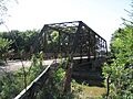
1916 Cottonwood River Pratt Truss Bridge west of Cedar Point (2012)
-
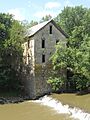
Cedar Point Mill in Cedar Point (2012)
-
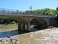
1914 Cottonwood River Bridge in Cottonwood Falls (2012)
-
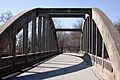
1923 Soden's Grove Bridge over Cottonwood River in Emporia (2005)


