Clements, Kansas facts for kids
Quick facts for kids
Clements, Kansas
|
|
|---|---|

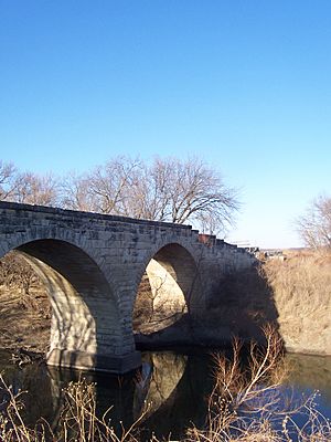
1886 Clements Stone Arch Bridge over Cottonwood River (2006)
|
|

|
|
| Country | United States |
| State | Kansas |
| County | Chase |
| Township | Cottonwood |
| Founded | 18?? (Crawfordsville) 1884 (Clements) |
| Elevation | 1,227 ft (374 m) |
| Time zone | UTC-6 (CST) |
| • Summer (DST) | UTC-5 (CDT) |
| Area code | 620 |
| FIPS code | 20-14000 |
| GNIS ID | 477389 |
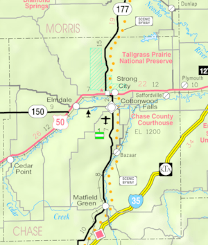
Clements is a small, unincorporated community in Chase County, Kansas. It's located about halfway between Strong City and Florence. You can find it near where U.S. Route 50 highway meets G Road.
Contents
A Look Back: Clements' Story
How Clements Began
For thousands of years, Native American groups lived as nomadic hunters on the Great Plains. They moved around to follow bison herds.
In the 16th to 18th centuries, France claimed a large part of North America. In 1762, after a war, France secretly gave this land to Spain.
In 1802, Spain returned most of the land to France. Then, in 1803, the United States bought a huge area from France. This was called the Louisiana Purchase. It included most of what is now Kansas.
In 1806, Zebulon Pike led an expedition west. Part of their journey followed the Cottonwood River. This river runs through Chase County, near where Clements is today.
In 1854, the Kansas Territory was created. Kansas officially became the 34th U.S. state in 1861. Chase County was established in 1859. This area included the land where Clements would later be built.
Important Events
In 1862, a post office opened in a nearby town called Silver Creek. This town no longer exists.
In 1871, the Atchison, Topeka and Santa Fe Railway built a main train line through the community. This railroad later merged and is now called BNSF Railway. Many local people still call it the "Santa Fe."

In 1881, the post office from Silver Creek moved to a train community called Crawfordsville. In 1884, Crawfordsville was renamed Clements. The post office closed in 1988.
In 1887, the famous Clements Stone Arch Bridge was finished. It crosses the Cottonwood River nearby.
Floods in Clements
Clements has experienced many floods over the years. In June and July 1951, very heavy rains caused rivers and streams to flood. Many cities in Kansas, including Clements, were affected. After this, many reservoirs and levees were built in Kansas. This was done to help control future floods.
Where is Clements?
Clements is located in the Flint Hills region of the Great Plains. The Cottonwood River flows through the southern part of the community.
Cool Places to Visit
Clements has one special place listed on the National Register of Historic Places listings in Chase County, Kansas (NRHP). This is the Clements Stone Arch Bridge. It was built in 1887 using local limestone.
The bridge has two arches. Its main arch is about 57 feet long, and the whole bridge is about 127 feet long. Today, only people walking can use this historic bridge.
Learning in Clements
The community is part of the Chase County USD 284 public school district. This district has two schools for students.
Getting Around
Both U.S. Route 50 highway and the BNSF Railway pass through Clements. These are important routes for travel and transportation.
 | James Van Der Zee |
 | Alma Thomas |
 | Ellis Wilson |
 | Margaret Taylor-Burroughs |


