
National Register of Historic Places listings in Chase County, Kansas facts for kids

Have you ever wondered about old buildings and places that are super important to history? In Chase County, Kansas, there are many such spots! This article is about the special places in Chase County that are listed on the National Register of Historic Places.
The National Register of Historic Places is like a special list kept by the United States government. It helps protect buildings, sites, and objects that are important to American history, architecture, archaeology, engineering, or culture. When a place is on this list, it means it's recognized as a valuable part of our past.
Chase County has 19 different places and areas on this list. These include old buildings, bridges, and even entire ranches. They tell us stories about how people lived, worked, and built things a long time ago in Kansas. Let's explore some of these amazing historic sites!
Historic Buildings and Structures
Chase County is home to many buildings and structures that have stood the test of time. These places show us the history of the area through their design and purpose.
Chase County Courthouse
The Chase County Courthouse is a very important building in Cottonwood Falls, Kansas. It's located right in the town square. This courthouse was built a long time ago, in 1871, and is known for its beautiful stone work. It's still used today for county government business, making it one of the oldest courthouses in Kansas that's still in use!
Courthouse.JPG)
Strong City Train Depot
The Strong City Atchison, Topeka, & Santa Fe Depot is an old train station in Strong City, Kansas. It was built in 1913 and was a busy place where people would catch trains and send goods. Imagine all the travelers and packages that passed through here! The depot had special rooms for passengers, a ticket office, and even a place for baggage. It stopped being a train depot in 1938, but it's still a cool reminder of the railroad's importance.

Cartter Building
Also in Cottonwood Falls, Kansas, the Cartter Building is another historic spot. It's located on Broadway, a main street in the town. This building was added to the National Register in 1977, showing its importance to the local history and architecture.

Chase County National Bank
Right next to the Cartter Building on Broadway is the Chase County National Bank. This building, listed in 1977, was once a busy bank. It's a great example of the kind of buildings that were important for business and community life in the past.

Cedar Point Mill
The Cedar Point Mill is an old mill found in Cedar Point, Kansas. Mills like this were super important long ago because they used water power to grind grain into flour. This mill was added to the National Register in 2006, recognizing its role in the area's farming history.

Historic Bridges
Chase County also has some amazing old bridges that are on the National Register. These bridges are not just ways to cross rivers; they are also examples of clever engineering from the past.
Clements Stone Arch Bridge
The Clements Stone Arch Bridge is a beautiful bridge located near Clements, Kansas. It crosses the Cottonwood River. What makes it special is that it's made of stone arches, which was a common way to build strong bridges a long time ago. It was listed in 1976.

Cottonwood River Bridge
Another important bridge is the Cottonwood River Bridge at the northern edge of Cottonwood Falls, Kansas. This bridge, on K-177, helps connect different parts of the county. It was recognized for its historical value in 1985.

Fox Creek Stone Arch Bridge
Similar to the Clements bridge, the Fox Creek Stone Arch Bridge near Strong City, Kansas is another impressive stone arch bridge. It's a great example of how durable and beautiful these old structures can be. It was added to the list in 2006.

Historic Ranches and Schools
Beyond buildings and bridges, Chase County also has historic ranches and even an old school that tell us about life in the past.
Clover Cliff Ranch House
The Clover Cliff Ranch House is located southwest of Elmdale, Kansas. This ranch house, listed in 1977, gives us a peek into the history of ranching in Kansas. Ranches were very important for raising cattle and farming in the region.

Lower Fox Creek School
Imagine going to school in a one-room schoolhouse! The Lower Fox Creek School near Strong City, Kansas is one such place. It was listed in 1974. These small schools were where many children in rural areas learned for generations. It's a great way to see how education used to be.

Spring Hill Farm and Stock Ranch House
Another historic ranch is the Spring Hill Farm and Stock Ranch House, located north of Strong City, Kansas. This ranch house was added to the National Register in 1971. It represents the history of farming and raising livestock in the area.

Images for kids
-
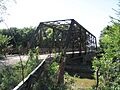
The Cottonwood River Pratt Truss Bridge.
-
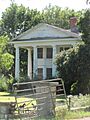
The Crocker Ranch.
-
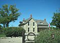
The Wood House in Cottonwood Falls.


.JPG)
