Marion Reservoir facts for kids
Quick facts for kids Marion Reservoir |
|
|---|---|

|
|
| Location | Marion County, Kansas |
| Coordinates | 38°22′08″N 97°05′06″W / 38.36889°N 97.08500°W |
| Type | Reservoir |
| Primary inflows | North Cottonwood River, French Creek |
| Primary outflows | North Cottonwood River to Cottonwood River |
| Catchment area | 200 square miles (520 km2) |
| Basin countries | United States |
| Managing agency | U.S. Army Corps of Engineers |
| Built | March 1964 |
| First flooded | February 1968 |
| Surface area | 6,160 acres (24.9 km2) |
| Water volume | 67,734 acre⋅ft (83,549,000 m3) |
| Shore length1 | 60 miles (97 km) |
| Surface elevation | 1,348.79 feet (411.11 m) |
| Settlements | Eastshore, Canada, Marion, Hillsboro, Durham |
| 1 Shore length is not a well-defined measure. | |
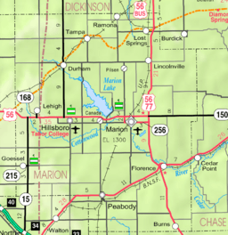
Marion Reservoir is a large lake in Kansas, about 3 miles (4.8 km) northwest of Marion. It's located in the beautiful Flint Hills area. This reservoir was finished in 1968 and is managed by the U.S. Army Corps of Engineers. Its main job is to help control floods.
Sometimes people call it 'Marion Lake,' but that name is older and not used much anymore. There's also a smaller lake nearby called Marion County Lake. To avoid confusion, most local people call the big one 'Reservoir' and the smaller one 'Lake.'
Exploring Marion Reservoir's Location
Marion Reservoir is found in Gale Township within Marion County, Kansas. You can enter the reservoir area from many different spots. A paved road runs along the top of the dam.
Near the south end of the dam, about half a mile north of U.S. Route 56, you'll find an information kiosk and public restrooms. The small community of Eastshore is located northeast of the dam. The closest cities are Marion to the east and Hillsboro to the west.
A Look Back: History of Marion Reservoir
Early History of the Land
For thousands of years, the Great Plains of North America were home to nomadic Native American tribes. They moved around, following animals and seasons.
From the 1500s to the 1700s, France claimed ownership of large parts of North America. After a war, France secretly gave this land to Spain in 1762.
19th Century Changes
In 1802, Spain returned most of the land to France. Then, in 1803, the United States bought a huge area, including what is now Kansas, from France. This was part of the Louisiana Purchase.
In 1806, Zebulon Pike led an expedition west from St. Louis, Missouri. Part of their journey followed the Cottonwood River right through the area where Marion Reservoir is today.
In 1854, the Kansas Territory was created. Kansas officially became the 34th U.S. state in 1861. Marion County, where the reservoir is, was established in 1855.
Building the Reservoir: 20th Century
In 1951, a huge event called the "Great Flood of 1951" happened. The Cottonwood River overflowed, causing a lot of damage. This massive flood was a big reason why people decided to build Marion Reservoir. It was designed to protect cities like Marion and Florence from future floods.
Construction on the Marion Reservoir began in March 1964. The main dam was finished in October 1967. By February 1968, the reservoir was fully ready to help control floods.
Modern Times: 21st Century Upgrades
In 2011, the Cottonwood Point recreation area was made even better. They added 61 new campsites and 23 new day-use areas. New picnic shelters and a new beach were also built for visitors to enjoy.
Fun at Marion Reservoir: Recreation Areas
Marion Reservoir is a great place for outdoor activities like camping and picnicking. There are four main parks to explore: Cottonwood Point, Hillsboro Cove, Marion Cove, and French Creek Cove.
Each campsite has picnic tables, grills or fire-rings, sun-shelters, and gravel parking spots. The "Class A" parks, Cottonwood Point and Hillsboro Cove, offer even more. They have electrical hookups for RVs, showers, and special stations to empty RV waste. You can also find group camping areas, playgrounds, and beaches there. Clean drinking water is available in all the parks.
Here are the recreation areas around Marion Reservoir:
- Cottonwood Point, Class A. Located north of U.S. Route 56 on Pawnee Road.
- French Creek Cove, Class C. Found north of U.S. Route 56 on Limestone Road.
- Hillsboro Cove, Class A. Situated north of U.S. Route 56 on Nighthawk Road.
- Marion Cove, Class C. Also north of U.S. Route 56 on Pawnee Road.
- Durham Cove. This area has a free, undeveloped boat ramp.
- Broken Bridge. Another spot with a free, undeveloped boat ramp.
- Overlook and Dam. Located north of U.S. Route 56 on Old Mill Road, offering great views.
 | William M. Jackson |
 | Juan E. Gilbert |
 | Neil deGrasse Tyson |


