Matfield Green, Kansas facts for kids
Quick facts for kids
Matfield Green, Kansas
|
|
|---|---|

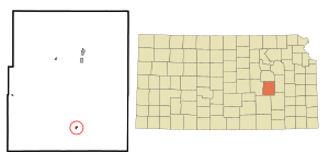
Location within Chase County and Kansas
|
|

|
|
| Country | United States |
| State | Kansas |
| County | Chase |
| Township | Matfield |
| Incorporated | 1924 |
| Named for | Matfield, England |
| Government | |
| • Type | Mayor–Council |
| Area | |
| • Total | 0.14 sq mi (0.37 km2) |
| • Land | 0.14 sq mi (0.37 km2) |
| • Water | 0.00 sq mi (0.00 km2) |
| Elevation | 1,306 ft (398 m) |
| Population
(2020)
|
|
| • Total | 49 |
| • Density | 350/sq mi (132.4/km2) |
| Time zone | UTC-6 (CST) |
| • Summer (DST) | UTC-5 (CDT) |
| ZIP code |
66862
|
| Area code | 620 |
| FIPS code | 20-45150 |
| GNIS ID | 477807 |
Matfield Green is a small city in Chase County, Kansas, in the United States. As of the 2020 census, about 49 people lived there. It is located along K-177 highway.
Contents
History of Matfield Green
Early History of the Land
For thousands of years, the Great Plains of North America were home to nomadic Native American tribes. These tribes moved around to hunt and gather food. Some historic tribes in Kansas included the Kansa, Osage, Pawnee, and Wichita. Other tribes like the Comanche, Apache, Kiowa, Cheyenne, and Arapaho also lived in the wider region.
In the 16th to 18th centuries, France claimed large parts of North America. After a war, France secretly gave this land to Spain in 1762.
Becoming Part of the United States
In 1802, Spain returned most of the land to France. Then, in 1803, the United States bought a huge area, including what is now Kansas, from France. This was called the Louisiana Purchase. The U.S. paid about 2.83 cents per acre for this land.
In 1854, the Kansas Territory was set up. Kansas officially became the 34th U.S. state in 1861. Chase County, where Matfield Green is located, was created in 1859.
Founding of Matfield Green
Matfield Green was named after a place called Matfield in England. There is a famous village green (a grassy area in the center of a village) in Matfield, Kent, England, known as Matfield Green.
In 1870, the area around Matfield Green had about 376 people. By 1880, this grew to 1,096 people. At its busiest, around the early 1900s, Matfield Green had about 350 residents. It had many businesses like a bank, grocery store, blacksmith, hardware store, flour mill, and even a hotel. It also had its own schools. A post office served the town from 1867 until 1995.
Matfield Green Today
Like many small towns in Kansas, Matfield Green faces challenges to keep going. A group of artists and writers helps preserve the community. They also work with the nearby historic Pioneer Bluffs ranch.
Big efforts have been made to protect the Flint Hills area, where Matfield Green is located. This area is one of the most important grasslands in the world. People like Texas billionaire Ed Bass and groups like Nature Conservancy are working to keep the Flint Hills natural and prevent too much building.
Geography
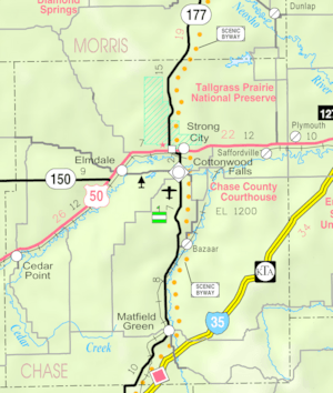
Matfield Green is located at 38°09′35″N 96°33′43″W / 38.159609°N 96.562013°W. It is in the beautiful Flint Hills region of the Great Plains. The city covers about 0.14 square miles (0.37 square kilometers), and all of it is land.
Climate
The weather in Matfield Green has hot and humid summers. Winters are usually mild to cool. This type of weather is called a humid subtropical climate.
Area Attractions
Matfield Green has two ranches that are listed on the National Register of Historic Places (NRHP). This means they are important historical sites.
- Crocker Ranch (NRHP)
- Pioneer Bluffs Ranch (NRHP): This ranch is about 1 mile north on K-177 Highway. It was built in the early 1900s and has about a dozen old farm buildings.
Population Information
| Historical population | |||
|---|---|---|---|
| Census | Pop. | %± | |
| 1880 | 324 | — | |
| 1930 | 182 | — | |
| 1940 | 146 | −19.8% | |
| 1950 | 119 | −18.5% | |
| 1960 | 95 | −20.2% | |
| 1970 | 77 | −18.9% | |
| 1980 | 71 | −7.8% | |
| 1990 | 33 | −53.5% | |
| 2000 | 60 | 81.8% | |
| 2010 | 47 | −21.7% | |
| 2020 | 49 | 4.3% | |
| U.S. Decennial Census | |||
Matfield Green is part of the Emporia Micropolitan Statistical Area.
2020 Census Details
The 2020 United States census counted 49 people living in Matfield Green. There were 28 households and 17 families. Most residents (about 96%) were white.
About 22% of the population was under 18 years old. About 20% were 65 years or older. The average age was around 48 years old.
2010 Census Details
In the census of 2010, there were 47 people living in the city. There were 24 households. All of the residents were white.
The average age in the city was 58.8 years. About 17% of residents were under 18. About 36% were 65 years or older.
Education
The local public schools are part of the Chase County USD 284 school district. There are two schools:
- Chase County Junior/Senior High School, located in Cottonwood Falls.
- Chase County Elementary School], also in Cottonwood Falls.
The schools in Matfield Green itself were closed when school districts were combined. The mascot for Matfield Green High School used to be the Matfield Green Panthers.
Transportation and Utilities
Transportation
The K-177 highway and the Southern Transcon railway line (run by BNSF Railway) both go through Matfield Green. The Kansas Turnpike (a toll road) is also nearby. To get to Matfield Green from the Turnpike, you would exit at Cassoday and then drive north on K-177.
Utilities
- Internet: Satellite internet is available from companies like HughesNet, StarBand, and WildBlue.
- TV: Satellite TV is provided by DirecTV and Dish Network. You can also watch free over-the-air ATSC digital TV.
See also
 In Spanish: Matfield Green para niños
 | May Edward Chinn |
 | Rebecca Cole |
 | Alexa Canady |
 | Dorothy Lavinia Brown |


