Saffordville, Kansas facts for kids
Quick facts for kids
Saffordville, Kansas
|
|
|---|---|

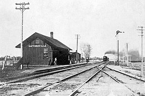
Atchison, Topeka and Santa Fe Railway depot in Saffordville, circa 1890-1900
|
|

|
|
| Country | United States |
| State | Kansas |
| County | Chase |
| Elevation | 1,148 ft (350 m) |
| Time zone | UTC-6 (CST) |
| • Summer (DST) | UTC-5 (CDT) |
| Area code | 620 |
| FIPS code | 20-62050 |
| GNIS ID | 477269 |
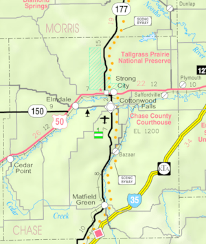
Saffordville is a small, unincorporated community in Chase County, Kansas, United States. This means it's like a tiny village without its own local government. You can find it about halfway between the towns of Strong City and Emporia. It's located near where the U.S. Route 50 highway meets Zz Road. The BNSF Railway also runs right through Saffordville.
Contents
A Look Back: Saffordville's History
For thousands of years, the land that is now Kansas was home to different groups of Native Americans. In 1803, the United States bought most of what is now Kansas as part of the Louisiana Purchase. Later, in 1854, the area became the Kansas Territory. Kansas officially became the 34th U.S. state in 1861. Chase County, where Saffordville is located, was created in 1859.
The Railroad and Early Growth
In 1871, the Atchison, Topeka and Santa Fe Railway built a main railroad line through the area. This helped the community grow. In 1996, this railroad joined with another company and became the BNSF Railway. Even today, many local people still call it the "Santa Fe" railroad. The old Santa Fe train station building is still there, but it has been closed for many years.
By 1921, Saffordville was a busy place with about 200 people. It had many businesses, including:
- a blacksmith shop (where metal items were made)
- an automobile garage (for fixing cars)
- a restaurant
- a barbershop
- a bank
- a grocery store
The Post Office Story
Saffordville's post office has had a few different names over the years.
- It first opened as Safford on December 31, 1872.
- On October 27, 1887, its name changed to Kenyon.
- Then, on October 3, 1888, it was renamed Saffordville.
The post office finally closed its doors on January 6, 1957.
When Floods Changed Everything
Saffordville faced many floods throughout its history. The first big flood happened in 1904. Then, there were eight more floods between 1923 and 1929.
The biggest flood happened in June and July 1951. Very heavy rains caused many rivers and streams in Kansas to overflow. The Cottonwood River, which is near Saffordville, flooded badly. This event is known as the Great Flood of 1951.
Because of this huge flood, the entire town of Saffordville was covered in about five feet of water! Everyone living there had to leave their homes. After the water went down, most people decided to move to drier places. Saffordville became a ghost town. Today, only a few buildings, like two homes and the old schoolhouse, remain.
Where Saffordville Is: Geography
Saffordville is located in the Cottonwood Valley. This area is part of the Flint Hills, which are rolling hills in the Great Plains region. The Cottonwood River is about 1 mile (1.6 kilometers) south of where the original community was.
The weather in Saffordville has hot, humid summers. The winters are usually mild to cool. According to a system that classifies climates, Saffordville has a humid subtropical climate. This type of climate is often shown as "Cfa" on climate maps.
Learning in Saffordville: Education
The community of Saffordville is part of the Chase County USD 284 public school district. This district has two schools for students.
Famous People from Saffordville
- Fred Brickell: He was a professional baseball player.
 | Mary Eliza Mahoney |
 | Susie King Taylor |
 | Ida Gray |
 | Eliza Ann Grier |


