
Peabody, Kansas facts for kids
Quick facts for kids
Peabody, Kansas
|
|
|---|---|

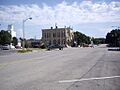
1886 Peabody City Hall at 300 N Walnut St (2010)
|
|

Location within Marion County and Kansas
|
|

|
|
| Country | United States |
| State | Kansas |
| County | Marion |
| Township | Peabody |
| Founded | 1870 (Coneburg) 1871 (Peabody) |
| Platted | 1871 (Coneburg) 1871, 1875 (Peabody) 1878 (North Peabody) |
| Incorporated | 1879 (Peabody) |
| Named for | John Cone (Coneburg) F.H. Peabody (Peabody) |
| Government | |
| • Type | Mayor–Council |
| Area | |
| • Total | 1.27 sq mi (3.28 km2) |
| • Land | 1.27 sq mi (3.28 km2) |
| • Water | 0.00 sq mi (0.00 km2) |
| Elevation | 1,375 ft (419 m) |
| Population
(2020)
|
|
| • Total | 937 |
| • Density | 738/sq mi (285.7/km2) |
| Time zone | UTC−6 (CST) |
| • Summer (DST) | UTC−5 (CDT) |
| ZIP Code |
66866
|
| Area code | 620, exchange 983 |
| FIPS code | 20-55100 |
| GNIS ID | 2396169 |
Peabody is a small city in Marion County, Kansas, United States. In 2020, about 937 people lived here. The city was named after F.H. Peabody from Boston, who was a vice-president of the Atchison, Topeka and Santa Fe Railway. Peabody is famous for its big July 4th celebration and its old downtown street from the 1880s. You can find Peabody between Newton and Florence along U.S. Route 50 highway.
History

Early Beginnings
For thousands of years, the Great Plains of North America were home to nomadic Native American tribes. In the 16th to 18th centuries, France claimed much of North America. Later, in 1762, France secretly gave New France to Spain.
In 1803, the United States bought most of the land that is now Kansas from France. This was part of the huge Louisiana Purchase. In 1861, Kansas became the 34th U.S. state. Marion County, where Peabody is located, was created in 1855.
Founding of Peabody
The first settler in the Peabody area arrived in 1864. In September 1870, a group of settlers from Wisconsin started a town called Coneburg. It was named after their company president, John Cone.
In 1871, another group started a new town nearby called Peabody. This new town had no land disputes, so businesses quickly moved there from Coneburg. The town of Peabody was officially planned out in June 1871. The railroad was built through Peabody on June 9, 1871.
A post office opened in Coneburg in January 1871, but it moved to Peabody in October 1871. In 1872, Coneburg became known as North Peabody. The two towns eventually joined together to form the city of Peabody in 1879.
The town of Peabody was named after F.H. Peabody, a former vice-president of the Atchison, Topeka and Santa Fe Railway. In 1874, Mr. Peabody visited the town and offered to donate money for a library building and books. The first library opened in June 1875. This library was used until 1914, when a new Peabody Township Carnegie Library was built in the same spot.
Railroads and Growth

In 1871, the Atchison, Topeka and Santa Fe Railway built a main line through Peabody. This railroad later became part of the BNSF Railway. Many locals still call it the "Santa Fe." Peabody was an important stop for trains. The first train station was destroyed in a wreck, and a second one was built. This second station was taken down in the 1970s. Now, the land is a park called Santa Fe Park. Today, Amtrak passenger trains still pass through Peabody, but they stop in nearby Newton.
In 1887, another railroad, the "Rock Island" line, was built through Peabody. This line connected Herington to Wichita. It is now part of the Union Pacific Railroad.
Peabody's Fair and Famous Horses
In 1875, Peabody held its first "county fair." In 1885, the Kansas State Fair was even held in Peabody! A special monument was built for General Grant at the fair. It was a tall tower made from forty bushels of corn. The fair had a large grandstand for 2000 people to watch horse races. The fairgrounds were later sold to the city in 1900 and became the Peabody City Park.
Peabody was also home to some very famous race horses around the year 1900.
- Joe Young was known as the "iron horse." He was the first horse west of the Mississippi River to sell for $10,000.
- Joe Young's son, Joe Patchen, earned $40,000 in races and later sold for $44,000.
- Joe Patchen's son, Dan Patch, sold for $60,000 in 1907.
Other famous local horses included McKinney and Silver Sign.
20th Century Changes


Peabody became an important place for feeding cattle in the early 1900s. Farmers grew more corn and other crops to feed the cattle.
From 1918 to 1920, Peabody had an oil boom. Many new houses were built, and the population grew by over 75%. However, the population later decreased as workers moved to other oil boom areas.
The New Santa Fe Trail road passed through Peabody in the late 1910s. This road later became U.S. Route 50 in the 1930s. In 1998, the highway was moved slightly north to go over a new railroad bridge.
During World War II, German and Italian prisoners of war were brought to Kansas to help with labor shortages. A small branch camp for up to 150 prisoners was set up in Peabody. These prisoners helped local farmers. The camp closed in December 1945.
Peabody has experienced many floods. In 1951, heavy rains caused major flooding in Kansas, including Peabody. This led to the building of many reservoirs and levees to prevent future floods.
Over time, Peabody became a "commuter town" for people working in the aircraft industry in Wichita. However, as the aircraft industry changed, and as farming became more automated, the town's population slowly decreased.
Peabody is proud of its history. In 1989, the Peabody Main Street Association was created to help preserve the town's past. In 1998, the downtown area of Peabody was added to the National Register of Historic Places (NRHP). This means it's a special place recognized for its history.
21st Century

In 2010, the Peabody Main Street Association won five state awards. Also in 2010, the Keystone-Cushing Pipeline was built east of Peabody. This pipeline caused some discussion about road damage and environmental concerns.
In 2012, the Peabody City Park was also added to the National Register of Historic Places.
Geography
Peabody is located in the beautiful Flint Hills and Great Plains regions of Kansas.
The city covers about 1.34 square miles (3.28 km2) of land. It is about 15 miles (24 km) north-east of Newton and 42 miles (68 km) north of Wichita.
Climate
In Peabody, January is usually the coldest month, with an average low of 19 °F (-7 °C). July is the warmest, with an average high of 92 °F (33 °C). May is the wettest month, with about 4.64 inches of rain. The hottest temperature ever recorded in Peabody was 115 °F (43 °C) in 1954. The coldest was -22 °F (-31 °C) in 1989.
| Climate data for Peabody, Kansas | |||||||||||||
|---|---|---|---|---|---|---|---|---|---|---|---|---|---|
| Month | Jan | Feb | Mar | Apr | May | Jun | Jul | Aug | Sep | Oct | Nov | Dec | Year |
| Record high °F (°C) | 76 (24) |
82 (28) |
91 (33) |
95 (35) |
101 (38) |
112 (44) |
115 (46) |
111 (44) |
109 (43) |
97 (36) |
88 (31) |
78 (26) |
115 (46) |
| Mean daily maximum °F (°C) | 41 (5) |
48 (9) |
59 (15) |
69 (21) |
77 (25) |
86 (30) |
92 (33) |
91 (33) |
82 (28) |
71 (22) |
55 (13) |
44 (7) |
68 (20) |
| Mean daily minimum °F (°C) | 19 (−7) |
24 (−4) |
34 (1) |
44 (7) |
53 (12) |
63 (17) |
68 (20) |
66 (19) |
58 (14) |
46 (8) |
33 (1) |
23 (−5) |
44 (7) |
| Record low °F (°C) | −17 (−27) |
−20 (−29) |
−6 (−21) |
12 (−11) |
27 (−3) |
40 (4) |
45 (7) |
45 (7) |
24 (−4) |
10 (−12) |
−9 (−23) |
−22 (−30) |
−22 (−30) |
| Average precipitation inches (mm) | 0.82 (21) |
0.96 (24) |
2.52 (64) |
2.82 (72) |
4.64 (118) |
4.49 (114) |
3.79 (96) |
3.33 (85) |
3.24 (82) |
2.53 (64) |
2.17 (55) |
1.07 (27) |
32.38 (822) |
| Source: The Weather Channel; National Weather Service | |||||||||||||
Demographics
| Historical population | |||
|---|---|---|---|
| Census | Pop. | %± | |
| 1880 | 1,087 | — | |
| 1890 | 1,474 | 35.6% | |
| 1900 | 1,369 | −7.1% | |
| 1910 | 1,416 | 3.4% | |
| 1920 | 2,455 | 73.4% | |
| 1930 | 1,491 | −39.3% | |
| 1940 | 1,367 | −8.3% | |
| 1950 | 1,194 | −12.7% | |
| 1960 | 1,309 | 9.6% | |
| 1970 | 1,368 | 4.5% | |
| 1980 | 1,474 | 7.7% | |
| 1990 | 1,349 | −8.5% | |
| 2000 | 1,384 | 2.6% | |
| 2010 | 1,210 | −12.6% | |
| 2020 | 937 | −22.6% | |
| U.S. Decennial Census | |||
Peabody's Population in 2020
The 2020 United States census counted 937 people living in Peabody. There were 397 households. Most residents (about 89.65%) were white. About 5.55% of the population was Hispanic or Latino.
About 24.7% of households had children under 18. The average household had 2.4 people. The average age in Peabody was 48.8 years old. About 20.1% of the population was under 18, and 24.2% was 65 or older.
Economy
The biggest employer in Peabody is the Peabody–Burns USD 398 school district. It runs two schools in the city.
Arts and culture
Fun Events in Peabody
- July 4 Celebration: This is a huge event with amazing fireworks in the historic Peabody City Park. The fireworks display is famous for its grand finale, called the "Battle of New Orleans." In the 1960s and 1970s, up to 30,000 people would come to watch!
- Doyle Valley Farmers Market: You can find fresh produce at the Santa Fe Park from Memorial Day to Labor Day, every Saturday morning.
Places to Visit

Peabody has six places listed on the National Register of Historic Places (NRHP). This means they are important historical sites.
- 1880s Peabody Downtown Historic District: This area has 42 historic buildings. Peabody is one of only two towns in Kansas to have its entire downtown district on the National Register of Historic Places!
- 1884 J.S. Schroeder Building: This building used to be a grocery store and now houses other businesses.
- 1914 Peabody Township Carnegie Library: This library was built with money from Andrew Carnegie. It was the first free, tax-supported library in Kansas!
- Peabody Museum Historical Complex: This complex includes several historic buildings.
- 1874 Peabody Historical Library Museum: This was Peabody's first library. After the new Carnegie library was built, this old building became a museum in 1961.
- 1881 W.H. Morgan House: A beautiful two-story house built by W.H. Morgan, who was the first editor of the Peabody Gazette newspaper.
- 1920 Peabody Printing Museum: This museum has old printing equipment from 1870 to 1920.
- Peabody City Park (NRHP):
- 1881 Fair Floral Exhibition Hall: This unique building has eight sides and is the only remaining building from the old county fair.
- 1974 Mennonite Centennial Memorial Monument: This monument in Santa Fe Park has parts of a threshing stone on its sides.
Education


Schools in Peabody
The community is served by the Peabody–Burns USD 398 public school district. This district includes Peabody, Burns, and nearby rural areas. There are two schools in Peabody:
- Peabody-Burns Junior/Senior High School: For students in 6th to 12th grade.
- Peabody-Burns Elementary School: For students from Pre-K to 5th grade.
Academics and Sports
The high school band is well-known for its performances. The high school is also part of T.E.E.N., a network that shares video teaching with other high schools.
The Peabody-Burns High School mascot is the Warrior. All school sports are managed by the Kansas State High School Activities Association.
- In 1977, the high school boys' football team placed 2nd in the state playoffs.
- In 1963, the high school boys' basketball team won 1st place in the state championship.
School History
The first school in Peabody started in 1871. The first high school classes were taught in 1879. In 1965, the Burns and Summit school districts joined with Peabody to form Unified School District 398. Now, all students in USD 398 attend schools in Peabody.
Library
Each school in the USD 398 district has a library for students.
The city also has the Peabody Township Carnegie Library at 214 North Walnut Street. This library was established in 1874 and became a Carnegie library in 1914. It was the first free, tax-supported library in Kansas! The library has fast internet and computers for public use. It also has a special painting called the "Peabody Roll of Honor," which lists all the men from Peabody Township who served in World War I.
Media
Local News
- Peabody Gazette-Bulletin: A local newspaper for Peabody and nearby towns.
- Hillsboro Free Press: A free newspaper for the greater Marion County area.
Radio and Television
Peabody gets its radio and TV signals from the Wichita-Hutchinson area. You can also get cable TV and satellite TV services.
Films
- Small Town, USA: A documentary film that looks at the challenges faced by small towns. Parts of this movie were filmed in Peabody.
Infrastructure
Transportation
Railroads
Two railroads pass through Peabody: BNSF Railway and Union Pacific Railroad. The BNSF Railway runs east-west, and the Union Pacific Railroad runs north-south. These two railroads cross each other in Peabody. Both railways used to have train stations in Peabody, but they were taken down in the 1960s and 1970s.
Highways
![]() U.S. Highway 50 runs along the northern edge of Peabody. In the past, this highway was known as the New Santa Fe Trail. In the 1930s, U.S. Route 50 was split into two routes, 50N and 50S, with Peabody on 50S. The highway was moved in 1998 to go over a new railroad bridge.
U.S. Highway 50 runs along the northern edge of Peabody. In the past, this highway was known as the New Santa Fe Trail. In the 1930s, U.S. Route 50 was split into two routes, 50N and 50S, with Peabody on 50S. The highway was moved in 1998 to go over a new railroad bridge.
Utilities
- Internet: Available through cable, wireless, and satellite providers.
- TV: Available through cable, satellite, and local digital TV stations.
- Telephone: Landline and cell phone services are available.
- Electricity: Provided by Westar Energy and other rural providers.
- Natural Gas: Provided by Atmos Energy.
- Water and Sewer: Provided by the City of Peabody.
- Trash: Provided by Waste Connections.
Notable people
- Warren Bechtel (1872–1933): He founded the Bechtel engineering and construction company, which is now one of the largest in the USA. He graduated from Peabody High School in 1891.
- Rebecca Ediger (born 1952): A United States Secret Service agent who received an award for her service to the President.
- Dennis Franchione (born 1951): A famous football coach who was the head coach of Peabody High School's football team from 1976 to 1977. His 1977 team placed 2nd in the state playoffs.
- Nick Hague (born 1975): A NASA astronaut and a Colonel in the United States Air Force. He attended grade school in Peabody.
- Frederic Remington (1861–1909): A famous American Old West artist. He spent time in the Peabody area.
- Oscar Stauffer (1886–1982): He founded Stauffer Communications and was the editor of the Peabody Gazette-Herald newspaper from 1915 to 1922.
Images for kids
-
Downtown Peabody (looking south in 2010)
-
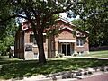
First Baptist Church (looking north in 2010)
-

Prairie Lawn Cemetery (looking east), north of U.S. 50 highway on Old Mill Rd (2010)


See also
 In Spanish: Peabody (Kansas) para niños
