
Burns, Kansas facts for kids
Quick facts for kids
Burns, Kansas
|
|
|---|---|

Burns United Methodist Church (2010)
|
|

Location within Marion County and Kansas
|
|

|
|
| Country | United States |
| State | Kansas |
| County | Marion |
| Township | Milton |
| Platted | 1880 |
| Incorporated | 1905 |
| Named for | Train station |
| Government | |
| • Type | Mayor–Council |
| Area | |
| • Total | 0.34 sq mi (0.89 km2) |
| • Land | 0.34 sq mi (0.89 km2) |
| • Water | 0.00 sq mi (0.00 km2) |
| Elevation | 1,496 ft (456 m) |
| Population
(2020)
|
|
| • Total | 234 |
| • Density | 688/sq mi (262.9/km2) |
| Time zone | UTC-6 (CST) |
| • Summer (DST) | UTC-5 (CDT) |
| ZIP code |
66840
|
| Area code | 620 |
| FIPS code | 20-09450 |
| GNIS ID | 2393471 |
Burns is a small city in Marion County, Kansas. In 2020, about 234 people lived there. The city got its name from a train station nearby. Burns is located between the cities of El Dorado and Florence. It sits next to U.S. Route 77 highway. The southern part of the city touches the border of Butler County.
A Look Back at Burns' History

Early Days of Kansas
For thousands of years, the Great Plains of North America were home to nomadic Native American tribes. In the 16th to 18th centuries, France claimed much of North America. In 1762, France gave its land, called New France, to Spain.
The 1800s: Land and Railroads
In 1803, the United States bought a huge area of land from France. This was called the Louisiana Purchase. It included most of what is now Kansas. In 1854, the Kansas Territory was created. Kansas became the 34th U.S. state in 1861. Marion County, where Burns is, was set up in 1855.
In 1877, a railroad company built a line from Florence to El Dorado. A train station named Burns was built north of where the city is today. The railroad line was later extended. The Atchison, Topeka and Santa Fe Railway operated this line. The section through Burns was closed in 1942.
A town called St. Francis was planned in August 1880 at the current city site. When the town officially became a city, they found out another city in Kansas was already named St. Francis. So, they changed the name to Burns, like the train station. The train station was then moved into the new city. A post office opened in Burns on November 30, 1880.
The 1900s and Beyond
Burns High School closed in 1965. This happened because school districts across Kansas were combining. Burns Elementary School and Junior High School closed in 1997 due to money problems. Today, students in Burns go to public schools in Peabody. These schools are part of the Peabody-Burns USD 398 district.
In 2010, the Keystone Pipeline was built about 6.5 miles west of Burns. This pipeline runs north to south through Marion County. Its construction caused some debate about road damage and environmental worries.
Where Burns Is Located
Burns is located at 38°5′26″N 96°53′14″W / 38.09056°N 96.88722°W. It is in the beautiful Flint Hills area. The city covers about 0.35 square miles (0.89 square kilometers) of land. The southern edge of Burns is the border between Marion County and Butler County.
Burns' Climate
The weather in Burns has hot, humid summers. Winters are usually mild to cool. Burns has a humid subtropical climate. This means it gets plenty of rain and has warm temperatures for much of the year.
People of Burns
| Historical population | |||
|---|---|---|---|
| Census | Pop. | %± | |
| 1910 | 489 | — | |
| 1920 | 622 | 27.2% | |
| 1930 | 455 | −26.8% | |
| 1940 | 409 | −10.1% | |
| 1950 | 294 | −28.1% | |
| 1960 | 314 | 6.8% | |
| 1970 | 268 | −14.6% | |
| 1980 | 224 | −16.4% | |
| 1990 | 226 | 0.9% | |
| 2000 | 268 | 18.6% | |
| 2010 | 228 | −14.9% | |
| 2020 | 234 | 2.6% | |
| U.S. Decennial Census | |||
2020 Census Information
In 2020, the 2020 United States census counted 234 people living in Burns. There were 83 households and 56 families. Most residents (about 96.58%) were white. About 3.42% of people were of two or more races. A small number (0.43%) were Hispanic or Latino.
About 32.5% of households had children under 18. Nearly half (49.4%) were married couples living together. The average household had 3.3 people. The average family had 3.6 people. About 29.9% of the population was under 18 years old. The median age in the city was 33.3 years.
2010 Census Information
The census in 2010 showed 228 people living in Burns. There were 93 households. The city's population density was about 651 people per square mile. Most residents (96.9%) were White. About 1.3% were African American.
About 29.0% of households had children under 18. Over half (51.6%) were married couples. The average household size was 2.45 people. The average family size was 3.14 people. The median age in Burns was 38 years old.
Education in Burns

Public Schools
Students in Burns attend schools in Peabody. These schools are part of the Peabody–Burns USD 398 school district.
- Peabody-Burns Junior/Senior High School
- Peabody-Burns Elementary School
- Sports Achievements
- In 1977, the Peabody-Burns High School boys football team won 2nd place in Class 2A.
- Historic Burns Schools
- Burns High School was located at Main and Cincinnati. It closed in 1965 and is now the Burns Community Museum. This was the first combined grade school and high school in Kansas. It was also the first to use a school "bus" (which were special wagons back in 1904). It is now on the National Register of Historic Places (NRHP).
- Burns Elementary & Junior High School was at Main and Church. It closed in 1997 and was later torn down.
- More Sports Achievements
- In 1953, the Burns High School boys basketball team won 1st place in Class B.
Private Schools
- Eden Christian School is a private Mennonite grade school. It is located about 3 miles south of Burns.
Public Library
The Burns Public Library serves the city. It is located at 104 North Washington Avenue. The library is part of the North Central Kansas Libraries System.
Media and Entertainment
Local News
- Peabody Gazette-Bulletin is a local newspaper for Burns, Florence, and Peabody.
- Hillsboro Free Press is a free newspaper for the wider Marion County area.
- The El Dorado Times is a regional newspaper from El Dorado.
Radio and TV
Burns can receive many radio stations from the Wichita-Hutchinson area. It also has access to satellite radio. For television, Burns gets over-the-air digital TV from the Wichita-Hutchinson area. Cable TV and satellite TV services are also available.
Filming Location
- The 1996 comedy science fiction movie Mars Attacks! filmed some scenes around Burns. These included the bus stop, cemetery, donut shop, and trailer park scenes. The movie studio, Warner Brothers, even gave a city sign from the film to Burns.
Getting Around Burns
U.S. 77 highway runs north-south along the east side of Burns. This highway generally follows the path of the old railway line.
Images for kids
-
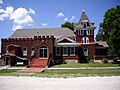
Burns United Methodist Church (2010)
-
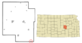
Location within Marion County and Kansas
-
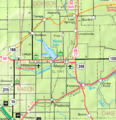
KDOT map of Marion County (legend)
See also
 In Spanish: Burns (Kansas) para niños
