Howard, Kansas facts for kids
Quick facts for kids
Howard, Kansas
|
|
|---|---|
|
City and County seat
|
|

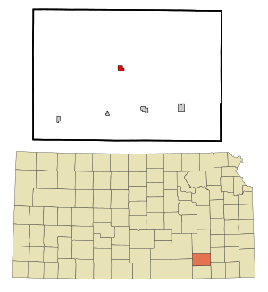
Location within Elk County and Kansas
|
|

|
|
| Country | United States |
| State | Kansas |
| County | Elk |
| Founded | 1870 |
| Incorporated | 1877 |
| Named for | Oliver O. Howard |
| Government | |
| • Type | Mayor–Council |
| Area | |
| • Total | 0.69 sq mi (1.80 km2) |
| • Land | 0.69 sq mi (1.80 km2) |
| • Water | 0.00 sq mi (0.00 km2) |
| Elevation | 1,040 ft (320 m) |
| Population
(2020)
|
|
| • Total | 570 |
| • Density | 826/sq mi (317/km2) |
| Time zone | UTC-6 (CST) |
| • Summer (DST) | UTC-5 (CDT) |
| ZIP code |
67349
|
| Area code | 620 |
| FIPS code | 20-33250 |
| GNIS ID | 2394429 |
Howard is a small city in Kansas, United States. It is the county seat of Elk County. This means it's the main town where the county government offices are located. In 2020, about 570 people lived in Howard.
Contents
History of Howard
Howard was started in 1870. It became an official city in 1877. The city was named after Oliver O. Howard. He was a general in the Civil War and also helped start Howard University. The first post office in Howard opened in February 1870. Around 1901, Howard had rules that meant only white people could live there.
Howard's Geography and Climate
Where is Howard?
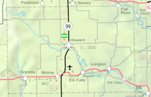
Howard is located in Elk County, Kansas. The city covers a total area of about 0.70 square miles (1.80 square kilometers). All of this area is land.
Howard's Climate
The weather in Howard has hot, humid summers. Winters are usually mild to cool. Howard has a humid subtropical climate. This type of climate is often called "Cfa" on climate maps.
| Climate data for Howard, Kansas, 1991–2020 normals, extremes 1907–present | |||||||||||||
|---|---|---|---|---|---|---|---|---|---|---|---|---|---|
| Month | Jan | Feb | Mar | Apr | May | Jun | Jul | Aug | Sep | Oct | Nov | Dec | Year |
| Record high °F (°C) | 79 (26) |
88 (31) |
94 (34) |
97 (36) |
99 (37) |
108 (42) |
115 (46) |
111 (44) |
109 (43) |
98 (37) |
90 (32) |
80 (27) |
115 (46) |
| Mean maximum °F (°C) | 67.1 (19.5) |
71.9 (22.2) |
79.7 (26.5) |
85.8 (29.9) |
89.3 (31.8) |
93.7 (34.3) |
99.8 (37.7) |
100.3 (37.9) |
95.9 (35.5) |
87.1 (30.6) |
76.2 (24.6) |
67.4 (19.7) |
101.9 (38.8) |
| Mean daily maximum °F (°C) | 43.5 (6.4) |
48.5 (9.2) |
58.6 (14.8) |
68.2 (20.1) |
76.2 (24.6) |
85.0 (29.4) |
90.4 (32.4) |
90.0 (32.2) |
82.4 (28.0) |
70.7 (21.5) |
57.3 (14.1) |
46.0 (7.8) |
68.1 (20.0) |
| Daily mean °F (°C) | 31.7 (−0.2) |
35.9 (2.2) |
45.4 (7.4) |
55.4 (13.0) |
64.9 (18.3) |
74.1 (23.4) |
78.9 (26.1) |
77.7 (25.4) |
69.4 (20.8) |
57.4 (14.1) |
44.7 (7.1) |
34.6 (1.4) |
55.8 (13.3) |
| Mean daily minimum °F (°C) | 19.9 (−6.7) |
23.3 (−4.8) |
32.3 (0.2) |
42.5 (5.8) |
53.5 (11.9) |
63.1 (17.3) |
67.5 (19.7) |
65.4 (18.6) |
56.5 (13.6) |
44.1 (6.7) |
32.1 (0.1) |
23.3 (−4.8) |
43.6 (6.5) |
| Mean minimum °F (°C) | 2.4 (−16.4) |
8.0 (−13.3) |
14.9 (−9.5) |
27.8 (−2.3) |
38.9 (3.8) |
52.1 (11.2) |
58.7 (14.8) |
55.6 (13.1) |
41.6 (5.3) |
27.8 (−2.3) |
16.1 (−8.8) |
6.7 (−14.1) |
−1.1 (−18.4) |
| Record low °F (°C) | −17 (−27) |
−18 (−28) |
−2 (−19) |
15 (−9) |
27 (−3) |
42 (6) |
47 (8) |
43 (6) |
27 (−3) |
12 (−11) |
−3 (−19) |
−17 (−27) |
−18 (−28) |
| Average precipitation inches (mm) | 1.03 (26) |
1.73 (44) |
2.75 (70) |
3.63 (92) |
5.09 (129) |
5.69 (145) |
4.01 (102) |
3.59 (91) |
3.54 (90) |
3.52 (89) |
2.23 (57) |
1.77 (45) |
38.58 (980) |
| Average snowfall inches (cm) | 2.2 (5.6) |
0.8 (2.0) |
0.9 (2.3) |
0.1 (0.25) |
0.0 (0.0) |
0.0 (0.0) |
0.0 (0.0) |
0.0 (0.0) |
0.0 (0.0) |
0.0 (0.0) |
0.9 (2.3) |
1.5 (3.8) |
6.4 (16.25) |
| Average precipitation days (≥ 0.01 in) | 4.1 | 4.8 | 6.8 | 7.9 | 9.6 | 8.6 | 7.6 | 6.4 | 6.7 | 6.3 | 5.1 | 4.9 | 78.8 |
| Average snowy days (≥ 0.1 in) | 1.6 | 1.2 | 0.6 | 0.1 | 0.0 | 0.0 | 0.0 | 0.0 | 0.0 | 0.0 | 0.3 | 1.4 | 5.2 |
| Source 1: NOAA | |||||||||||||
| Source 2: National Weather Service | |||||||||||||
People in Howard
| Historical population | |||
|---|---|---|---|
| Census | Pop. | %± | |
| 1880 | 683 | — | |
| 1890 | 1,015 | 48.6% | |
| 1900 | 1,207 | 18.9% | |
| 1910 | 1,163 | −3.6% | |
| 1920 | 1,060 | −8.9% | |
| 1930 | 1,069 | 0.8% | |
| 1940 | 1,170 | 9.4% | |
| 1950 | 1,149 | −1.8% | |
| 1960 | 1,017 | −11.5% | |
| 1970 | 918 | −9.7% | |
| 1980 | 965 | 5.1% | |
| 1990 | 815 | −15.5% | |
| 2000 | 808 | −0.9% | |
| 2010 | 687 | −15.0% | |
| 2020 | 570 | −17.0% | |
| U.S. Decennial Census | |||
2020 Population Details
In 2020, the 2020 United States census counted 570 people living in Howard. There were 268 households and 148 families. A household is a group of people living together, and a family is a group of related people living together.
Most people in Howard (about 90.88%) were white. A small number were black, Native American, or Asian. About 4.56% of the population was Hispanic or Latino.
About 20.1% of households had children under 18. Many households (39.9%) had just one person living there. About 28.0% of households had someone aged 65 or older living alone.
The average age in Howard was 51.5 years. About 23.7% of the people were under 18 years old. About 29.6% were 65 years or older.
The average income for a household was about $39,750 per year. About 23.7% of all people in Howard lived below the poverty line. This means their income was below a certain level.
Education in Howard
The schools in Howard are part of the West Elk USD 282 public school district. This district was formed when schools from Moline, Howard, and Severy joined together.
West Elk High School is located in Howard. The school's sports teams and groups are called the Patriots. Before the schools joined, the Howard High School mascot was the Pirates.
See also
 In Spanish: Howard (Kansas) para niños

