Wann, Oklahoma facts for kids
Quick facts for kids
Wann, Oklahoma
|
|
|---|---|

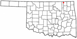
Location of Wann, Oklahoma
|
|
| Country | United States |
| State | Oklahoma |
| County | Nowata |
| Area | |
| • Total | 0.17 sq mi (0.44 km2) |
| • Land | 0.17 sq mi (0.44 km2) |
| • Water | 0.00 sq mi (0.00 km2) |
| Elevation | 853 ft (260 m) |
| Population
(2020)
|
|
| • Total | 95 |
| • Density | 555.56/sq mi (214.05/km2) |
| Time zone | UTC-6 (Central (CST)) |
| • Summer (DST) | UTC-5 (CDT) |
| ZIP code |
74083
|
| Area code(s) | 539/918 |
| FIPS code | 40-78250 |
| GNIS feature ID | 2413447 |
Wann is a small town in Nowata County, Oklahoma, in the United States. In 2020, about 95 people lived there. Wann is known for its "Six Flag Poles Over Wann America."
Contents
History of Wann
The town of Wann has a rich history connected to the Cherokee and Eastern Delaware Native American tribes. The area was first called Coon, named after a Delaware family. This was when the first post office opened on July 26, 1895.
Later, on October 13, 1899, the town was renamed Wann. This was done to honor Robert F. Wann, a local Cherokee person. Wann was an important stop on the stagecoach route. This route connected Coffeyville, Kansas and Bartlesville, Indian Territory.
In 1902, the Katy Railroad built its tracks a bit northwest of the town. So, the people of Wann moved their homes and businesses closer to the new Wann railroad station.
Growth and Change in Wann
When Oklahoma had its first official count of people in 1907, Wann had 201 residents. Around this time, oil was found nearby in what was called the Wann Oil Pool. This discovery caused the town to grow a lot! The population jumped to 286 people in 1910 and then to 404 in 1920.
However, the oil boom did not last forever. When the oil production slowed down, the town's population also started to shrink. In the 1980s, the Katy Railroad stopped using its tracks, and the railway was abandoned. Today, Wann's economy mainly relies on local farming and ranching.
Geography of Wann
Wann is a small town in terms of its size. According to the United States Census Bureau, the town covers a total area of about 0.2 square miles (0.44 square kilometers). All of this area is land, with no water within the town limits.
People of Wann
| Historical population | |||
|---|---|---|---|
| Census | Pop. | %± | |
| 1910 | 286 | — | |
| 1920 | 404 | 41.3% | |
| 1930 | 168 | −58.4% | |
| 1940 | 147 | −12.5% | |
| 1950 | 99 | −32.7% | |
| 1960 | 157 | 58.6% | |
| 1970 | 135 | −14.0% | |
| 1980 | 156 | 15.6% | |
| 1990 | 126 | −19.2% | |
| 2000 | 132 | 4.8% | |
| 2010 | 125 | −5.3% | |
| 2020 | 95 | −24.0% | |
| U.S. Decennial Census | |||
The census helps us understand who lives in Wann. In 2000, there were 132 people living in the town. These people lived in 50 different homes, and 35 of these were families.
Most of the people in Wann were White (about 68%). About 21% were Native American. Around 10% of the people were from two or more racial backgrounds. Some people (about 7.5%) identified as Hispanic or Latino.
Households and Families
Out of the 50 homes in Wann in 2000, about 36% had children under 18 living there. Most homes (60%) were married couples living together. About 8% of homes had a female head of household without a husband. Around 30% of all homes were single individuals.
The average number of people in each home was about 2.64. For families, the average size was about 3.09 people.
Age in Wann
The population of Wann in 2000 was spread out by age. About 34% of the people were under 18 years old. Around 25% were between 25 and 44 years old. About 24% were between 45 and 64 years old. And about 11% were 65 years old or older. The average age in Wann was 35 years.
For every 100 females, there were about 94 males in Wann. For every 100 females aged 18 and over, there were about 107 males.
See also
 In Spanish: Wann (Oklahoma) para niños
 | Delilah Pierce |
 | Gordon Parks |
 | Augusta Savage |
 | Charles Ethan Porter |

