
Cherokee County, Kansas facts for kids
Quick facts for kids
Cherokee County
|
|
|---|---|

Tri-State Marker (2006)
|
|

Location within the U.S. state of Kansas
|
|
 Kansas's location within the U.S. |
|
| Country | |
| State | |
| Founded | February 18, 1860 |
| Named for | Cherokee Native Americans |
| Seat | Columbus |
| Largest city | Baxter Springs |
| Area | |
| • Total | 591 sq mi (1,530 km2) |
| • Land | 588 sq mi (1,520 km2) |
| • Water | 3.5 sq mi (9 km2) 0.6%% |
| Population
(2020)
|
|
| • Total | 19,362 |
| • Density | 32.9/sq mi (12.7/km2) |
| Time zone | UTC−6 (Central) |
| • Summer (DST) | UTC−5 (CDT) |
| Area code | 620 |
| Congressional district | 2nd |
Cherokee County is a place in Kansas, a state in the United States. It's located in the southeastern part of Kansas. The main city where the county government is located is Columbus. The biggest city in the county is Baxter Springs. In 2020, about 19,362 people lived here. The county got its name from the Cherokee Native American tribe.
History
How the Land Became Part of the U.S.
In 1803, the United States bought a huge amount of land from France. This was called the Louisiana Purchase. It was 828,000 square miles and cost about 2.83 cents per acre. Most of what is now Kansas was part of this big purchase.
Native American Lands
In the 1830s, the U.S. government moved many Native American tribes. These tribes, including the Five Civilized Tribes, were moved from the southeastern U.S. to lands west of the Mississippi River. This was called Indian Removal. Most of these lands are now in Oklahoma.
At that time, part of Kansas was known as the Cherokee Neutral Lands. This area was set aside for the Cherokee tribe. That's why Cherokee County was named after them.
Kansas Becomes a State
In 1854, the U.S. created the Kansas Territory. People began to move into this new territory. There was a lot of fighting between people who wanted slavery and those who wanted to end it.
In 1861, Kansas officially became the 34th state in the U.S. Its constitution said that slavery was not allowed. Cherokee County was officially created in 1860, just before Kansas became a state.
Geography
Cherokee County covers about 591 square miles. Most of this area, about 588 square miles, is land. The rest, about 3.5 square miles, is water.
Neighboring Counties
Cherokee County shares borders with several other counties:
- Crawford County (to the north)
- Jasper County, Missouri (to the east)
- Newton County, Missouri (to the southeast)
- Ottawa County, Oklahoma (to the south)
- Craig County, Oklahoma (to the southwest)
- Labette County (to the west)
Main Roads and Highways
Many important roads run through Cherokee County. These include:
- U.S. Route 69
- U.S. Route 160
- U.S. Route 166
- Kansas Highway 7
- Kansas Highway 26
- Kansas Highway 57
- Kansas Highway 66 (this road replaced the old U.S. Route 66)
- Kansas Highway 96
- Kansas Highway 102
Population Information
| Historical population | |||
|---|---|---|---|
| Census | Pop. | %± | |
| 1860 | 1,501 | — | |
| 1870 | 11,038 | 635.4% | |
| 1880 | 21,905 | 98.5% | |
| 1890 | 27,770 | 26.8% | |
| 1900 | 42,694 | 53.7% | |
| 1910 | 38,162 | −10.6% | |
| 1920 | 33,609 | −11.9% | |
| 1930 | 31,457 | −6.4% | |
| 1940 | 29,817 | −5.2% | |
| 1950 | 25,144 | −15.7% | |
| 1960 | 22,279 | −11.4% | |
| 1970 | 21,549 | −3.3% | |
| 1980 | 22,304 | 3.5% | |
| 1990 | 21,374 | −4.2% | |
| 2000 | 22,605 | 5.8% | |
| 2010 | 21,603 | −4.4% | |
| 2020 | 19,362 | −10.4% | |
| 2023 (est.) | 19,054 | −11.8% | |
| U.S. Decennial Census 1790-1960 1900-1990 1990-2000 2010-2020 |
|||
In 2020, the population of Cherokee County was 19,362 people. This number changes over time. The table above shows how the population has changed since 1860.
Education
There are several school districts in Cherokee County. These districts help make sure students get a good education.
School Districts in the County
- Southeast USD 247 (also known as Cherokee USD 247)
- Riverton USD 404
- Columbus USD 493
- Galena USD 499
- Baxter Springs USD 508
Other School Districts Nearby
Some parts of Cherokee County might also be served by these districts:
- Chetopa-St. Paul USD 505
- Oswego USD 504
- Pittsburg USD 250
Communities

Cherokee County has several cities and smaller communities.
Cities
- Baxter Springs
- Columbus (this is the county seat)
- Galena
- Roseland
- Scammon
- Weir
- West Mineral
Unincorporated Communities
These are smaller towns or areas that are not officially cities.
- Carona
- Cokedale
- Crestline†
- Empire City
- Faulkner
- Hallowell†
- Keelville
- Kniveton‡
- Lawton
- Lowell†
- Melrose
- Neutral
- Riverton†
- Sherman
- Sherwin
- Skidmore
- Stippville
- Turck
‡ means part of the community is in another county. † means the U.S. Census Bureau counts this as a special place.
Ghost Towns
- Treece was once a town, but it was officially closed down in 2012.
Images for kids
-
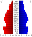
This chart shows the age groups of people in Cherokee County based on the 2000 census.

See also
 In Spanish: Condado de Cherokee (Kansas) para niños
