Treece, Kansas facts for kids
Quick facts for kids
Treece, Kansas
|
|
|---|---|

Treece (2016)
|
|

Location within Cherokee County and Kansas
|
|

|
|
| Country | United States |
| State | Kansas |
| County | Cherokee |
| Founded | 1910s |
| Disincorporated | 2012 |
| Area | |
| • Total | 0.1 sq mi (0.2 km2) |
| • Land | 0.1 sq mi (0.2 km2) |
| • Water | 0 sq mi (0.0 km2) |
| Elevation | 840 ft (260 m) |
| Population
(2010)
|
|
| • Total | 138 |
| • Estimate
(2016)
|
1 |
| • Density | 1,400/sq mi (690/km2) |
| Time zone | UTC-6 (CST) |
| • Summer (DST) | UTC-5 (CDT) |
| ZIP code |
66778
|
| Area code | 620 |
| FIPS code | 20-71350 |
| GNIS ID | 469375 |
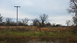
Treece is a ghost town located in Cherokee County, Kansas, United States. It was once a busy mining town. However, it is now mostly empty because of serious lead pollution from old mining activities.
By 2012, almost all buildings in Treece were torn down. Most people had moved away. Only a few residents chose to stay at first.
Contents
History of Treece
Treece and nearby towns like Picher were created because of mining in the early 1900s. The town got its name from a realtor named J. O. Treece. The first post office opened in Treece in 1917.
Mining in Treece
Treece was very important for mining lead, zinc, and iron ore. During its busiest times, Treece and Picher together had over 20,000 people. They produced a huge amount of ore, especially during World War I and World War II.
After the 1970s, mining slowed down a lot. The number of people living in Treece also dropped quickly.
Environmental Concerns and Cleanup Efforts
In 1981, the Environmental Protection Agency (EPA) said that the Tri-State Mining District was polluted. They promised to clean up the area.
The EPA divided the cleanup into different areas called "Superfund Sites." Treece was part of the Cherokee County Superfund Site. It was called "OU4." Even though Treece was close to Picher, Oklahoma, which also closed due to lead pollution, they were handled as separate cleanup projects.
At first, the EPA wanted to clean the soil in Treece. They did not plan to move the people. But in October 2009, the U.S. Congress passed a law. This law allowed the EPA to buy out the homes in Treece.
Residents had until August 31, 2010, to ask for a federal buyout. Offers were made to 80 residents in December. By May 2012, only one couple had refused the offer and stayed in Treece. All other buildings were sold or torn down.
Despite the money spent, not much cleanup of the mine waste has happened. In 2012, the State of Kansas officially closed the city of Treece.
Contamination in Treece
The EPA decided that Treece was not safe to live in. This was because of large piles of mining waste called "chat piles" and leftover "mine tailings." These piles still exist in the abandoned town.
Dangers of Lead Pollution
A writer visited Treece in 2010. Some residents told him that before the EPA declared the town unsafe, children who swam in Tar Creek would get chemical burns. These burns looked like bad sunburns.
The chat piles and mine tailings are dangerous because they contain a lot of lead. Even small amounts of lead can be harmful over time. If people are exposed to lead for a long time, it can cause serious health problems. These include high blood pressure, heart disease, kidney disease, and problems with fertility. No studies have checked the long-term health effects on former Treece residents.
Some chat piles in Treece are as tall as 200 ft (61 m). The dust from these piles still has enough metal to make lead levels in children's blood three times higher than the national average. This shows that people in Treece lived with dangerous amounts of toxic waste for 50–60 years before action was taken.
Water Pollution
When mining stopped, the companies turned off the water pumps in the mines. This caused the mines to flood. As the floodwater moved through the tunnels, it picked up leftover minerals. This polluted water then flowed into Tar Creek and other streams. This harmed the water and the local wildlife. Tar Creek runs through Treece and other towns that faced similar problems.
Geography
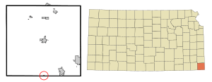
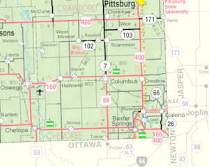
Treece is located in southeast Kansas. It is right next to the Kansas-Oklahoma border. It is just west of U.S. Route 69. The town of Picher, Oklahoma is about one mile south of Treece.
The city covers a total area of 0.1 square miles (0.26 km2). All of this area is land.
Population Changes
| Historical population | |||
|---|---|---|---|
| Census | Pop. | %± | |
| 1930 | 749 | — | |
| 1940 | 568 | −24.2% | |
| 1950 | 378 | −33.5% | |
| 1960 | 280 | −25.9% | |
| 1970 | 225 | −19.6% | |
| 1980 | 194 | −13.8% | |
| 1990 | 172 | −11.3% | |
| 2000 | 149 | −13.4% | |
| 2010 | 138 | −7.4% | |
| 2016 (est.) | 1 | −99.3% | |
| U.S. Decennial Census, Census 2000 | |||
In May 2012, only one couple who had refused the EPA buyout offer still lived in Treece.
On August 30, 2016, Timothy Busby, one of the last two residents, passed away at age 54. His wife, Della Busby, lived with him in Treece until his death.
See also
 In Spanish: Treece (Kansas) para niños
 | John T. Biggers |
 | Thomas Blackshear |
 | Mark Bradford |
 | Beverly Buchanan |

