Jasper County, Missouri facts for kids
Quick facts for kids
Jasper County
|
|
|---|---|
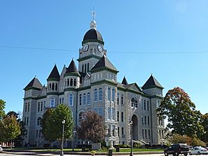
Jasper County Courthouse in Carthage (August 2008)
|
|
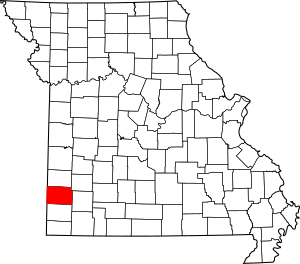
Location within the U.S. state of Missouri
|
|
 Missouri's location within the U.S. |
|
| Country | |
| State | |
| Founded | January 2, 1841 |
| Named for | William Jasper |
| Seat | Carthage |
| Largest city | Joplin |
| Area | |
| • Total | 641 sq mi (1,660 km2) |
| • Land | 638 sq mi (1,650 km2) |
| • Water | 2.8 sq mi (7 km2) 0.4% |
| Population
(2020)
|
|
| • Total | 122,761 |
| • Density | 192.3/sq mi (74.2/km2) |
| Time zone | UTC−6 (Central) |
| • Summer (DST) | UTC−5 (CDT) |
| Congressional district | 7th |
Jasper County is a county in the southwest part of Missouri, a state in the United States. In 2020, about 122,761 people lived here. The main city and county seat is Carthage. The largest city in the county is Joplin.
Jasper County was created in 1841. It was named after William Jasper, a brave hero from the American Revolutionary War. The county is part of the Joplin area, which is a larger group of cities and towns. The Jasper County Sheriff's Office helps keep everyone safe throughout the county.
Contents
History of Jasper County
The Osage Nation
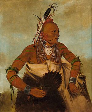
Long before Europeans arrived, the land that is now Jasper County was home to the Osage Native Americans. They called themselves the "Children of the Middle Waters." This tribe spoke a Siouan language. They had moved west and south many centuries ago from the Ohio Valley.
The Osage were a strong tribe. They controlled a large area of land. This land stretched between the Missouri River and Osage River to the north. It also reached the Mississippi River to the east and the Arkansas River to the south. To the west, they hunted buffalo on the Great Plains.
The first time Europeans wrote about meeting the Osage was in 1673. A French explorer and priest named Jacques Marquette made a map. He wrote down the name of the people he met as Ouchage. This was his way of writing their name using French sounds. Later, French explorers found a smaller Osage village. They called it Ouazhigi. Over time, the French started spelling the tribe's name as Osage. English speakers later used this spelling too.
In 1682, Robert de La Salle traveled down the Mississippi River. He claimed the entire area for France. He named it "La Louisiane" after King Louis XIV. This area became part of New France. The French divided Louisiana into two parts. The Arkansas River was the dividing line.
After a big war called the Seven Years' War in 1763, France lost Louisiana to Spain. Great Britain took over most of the other French lands east of the Mississippi River. For a while, present-day Jasper County was in a Spanish area called New Madrid.
Later, France secretly got Louisiana back from Spain in 1800. But in 1803, the French leader Napoleon decided to sell this land to the United States. This sale is known as the Louisiana Purchase.
The Osage tribe made treaties with the United States. In 1808, they gave up some of their lands in Missouri. This was called the Osage Treaty. The Osage moved from their homes on the Osage River to the Jasper County area. In 1825, they gave up more of their traditional lands. These lands were in Missouri, Arkansas, and Oklahoma. They were first moved to a reservation in Kansas. Then, in 1872, they had to move again to Indian Territory (which is now Oklahoma).
Missouri Territory is Formed
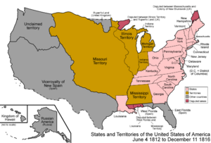
The area that included Jasper County was renamed the Missouri Territory in 1812. This was to avoid confusion with the new state of Louisiana. The old New Madrid District became New Madrid County.
Over the years, the borders of counties in Missouri changed many times. In 1815, Lawrence County was created. It covered most of what is now southwest Missouri and part of Arkansas. In 1818, Lawrence County was renamed Wayne County.
In 1820, all of Missouri Territory became the state of Missouri. As more people moved into the area, new counties were formed. In 1831, Crawford County was created from Wayne County. It covered the southern part of Missouri, including the future Jasper County.
Then, in 1833, Greene County was organized from Crawford County. It stretched west to the Kansas state line. On January 5, 1835, a large part of Greene County became Barry County. Finally, in 1838, Barry County was divided into four parts: Barry, Dade, Newton, and Jasper counties. At first, Jasper County was not fully independent. It was connected to Newton County until 1841.
Jasper County is Organized
On January 29, 1841, the Missouri Legislature passed a law to officially create Jasper County. It was named after Sergeant William Jasper, a hero from the American Revolutionary War. The county court first divided the area into three townships: North Fork, Center Creek, and Marion. Later, it was organized into 15 townships, which are still used today.
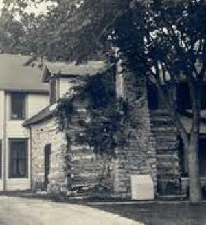
The first county court meeting was held on February 25, 1841. It took place in the log cabin home of George Hornback. This cabin was about one and a half miles northwest of Carthage, near the Spring River. The court officers were Charles S. Yancey, the judge, and Elwood B. James, the clerk. John P. Osborn was the first sheriff. He announced that the court would meet at Hornback's home until a permanent county seat was chosen. The first court session lasted two days.
A permanent county seat was chosen in March 1842. It was named Carthage. The first courthouse was a small, one-room wooden building. It was finished on June 29, 1842. It stood on the north side of the public square in Carthage. This building was later replaced by a larger, two-story brick and stone courthouse in 1854. This new building also had a county jail.
At a court meeting in October 1842, two lawyers, Robert W. Crawford and John R. Chenault, were fined ten dollars. They were fined for "fighting in the presence and view of said court."
The Civil War Years
When the American Civil War began in 1861, Jasper County had several small towns. There were also some mining camps. Carthage, the county seat, had about 400 to 500 people. The newer brick courthouse was used as a hospital during the war. It was destroyed by fire during fighting in October 1863.
By the end of the war, Carthage was empty and completely ruined. Much of Jasper County was also destroyed. No courts were held in Jasper County between May 1861 and October 1865, except for military courts.
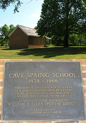
In 1865, the governor ordered the courthouse to be moved. It was temporarily set up in the pioneer schoolhouse at Cave Springs. This is near present-day La Russell, Missouri. The county court used other temporary places until the current Jasper County Courthouse was built. This beautiful courthouse was constructed in Carthage in the mid-1890s.
In 2001, Jasper County adopted an official flag. It was shown for the first time during the county's 160th birthday party. The flag shows the county courthouse. It has 15 stars around it, representing the 15 townships in Jasper County. The blue and red stars in the middle remember the difficult times during the Civil War. This includes the Battle of Carthage in 1861 and another battle in 1863.
Towns Before the Civil War
Many towns were started in Jasper County before the Civil War. Some of them were destroyed during the war and no longer exist.
| Current Town Name | Date Founded | Notes |
|---|---|---|
| Sarcoxie | 1833 | This was the first settlement in Jasper County. It was first called Centerville. |
| (Old) Jasper | 1840 | This town was northeast of Carthage and is gone now. The current town of Jasper, Missouri is a different community. |
| Carthage | 1841 | Carthage was planned to be the county seat. It was quickly rebuilt after being destroyed in the Civil War. |
| (Old) Sherwood | 1846 | First called Rural, it was near present-day Webb City. It was destroyed in the Civil War and no longer exists. |
| Oronogo | 1848 | This town grew from early mining camps. It was also known as Minersville and Leadville Hollow. |
| (Old) Medoc | 1848 | This started as an old trading post near the Kansas state line. It was destroyed in the Civil War and later abandoned. |
| Avilla | 1856 | Business owners started Avilla. Its citizens formed a local army to protect it during the Civil War. It survived the war undamaged. |
| Fidelity | 1856 | William Cloe is thought to have founded Fidelity around the same time as Avilla. |
| Waco | 1857 | This started as an old trading post first called Loshick. |
| (Old) Preston | 1859 | This village was northwest of Carthage. It no longer exists. |
Geography
Jasper County covers a total area of about 641 square miles. Most of this (638 square miles) is land. About 2.8 square miles (0.4%) is water.
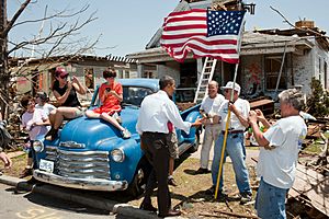
On May 22, 2011, a very strong tornado hit Joplin, a city in Jasper County. This 2011 Joplin tornado was an EF5 tornado. It was one of the deadliest tornadoes in American history.
Neighboring Counties
Jasper County shares borders with these other counties:
- Barton County (north)
- Dade County (northeast)
- Lawrence County (east)
- Newton County (south)
- Cherokee County, Kansas (west)
- Crawford County, Kansas (northwest)
Main Roads
 Interstate 44
 Interstate 49
 U.S. Route 66 (1926–1985)
 U.S. Route 71
 Route 37
 Route 43
 Route 66
 Route 96
 Route 171
 Route 249
People and Population
| Historical population | |||
|---|---|---|---|
| Census | Pop. | %± | |
| 1850 | 4,223 | — | |
| 1860 | 6,883 | 63.0% | |
| 1870 | 14,928 | 116.9% | |
| 1880 | 32,019 | 114.5% | |
| 1890 | 50,500 | 57.7% | |
| 1900 | 84,018 | 66.4% | |
| 1910 | 89,673 | 6.7% | |
| 1920 | 75,941 | −15.3% | |
| 1930 | 73,810 | −2.8% | |
| 1940 | 78,705 | 6.6% | |
| 1950 | 79,106 | 0.5% | |
| 1960 | 78,863 | −0.3% | |
| 1970 | 79,852 | 1.3% | |
| 1980 | 86,958 | 8.9% | |
| 1990 | 90,465 | 4.0% | |
| 2000 | 104,686 | 15.7% | |
| 2010 | 117,404 | 12.1% | |
| 2020 | 122,761 | 4.6% | |
| 2022 (est.) | 124,075 | 5.7% | |
| U.S. Decennial Census 1790-1960 1900-1990 1990-2000 2010-2019 |
|||
In 2010, there were 117,404 people living in Jasper County. There were 45,639 homes and 30,202 families. The county had about 164 people per square mile.
Most people in the county (88.24%) were White. About 1.93% were Black or African American. About 1.51% were Native American. About 6.84% of the population were Hispanic or Latino.
About 30.8% of homes had children under 18 living there. About 48.7% were married couples. The average home had 2.52 people. The average family had 3.05 people.
The median age in the county was 35.1 years old. This means half the people were younger than 35.1 and half were older. About 27.17% of the population was under 19. About 12.14% were 65 or older.
The median income for a household was $31,323. This means half of the households earned more than this, and half earned less. About 14.50% of the people lived below the poverty line. This included 19.20% of those under 18.
2020 Census Information
| Race | Number | Percent |
|---|---|---|
| White (Not Hispanic) | 96,388 | 78.51% |
| Black or African American (Not Hispanic) | 2,260 | 1.84% |
| Native American (Not Hispanic) | 1,894 | 1.54% |
| Asian (Not Hispanic) | 1,491 | 1.21% |
| Pacific Islander (Not Hispanic) | 440 | 0.36% |
| Other/Mixed (Not Hispanic) | 8,911 | 7.26% |
| Hispanic or Latino | 11,377 | 9.3% |
Education
Jasper County has many schools for students from kindergarten through 12th grade. These schools are part of different school districts. Some districts also have schools in other counties.
- Carl Junction R-I School District
- Carthage R-IX School District
- Diamond R-IV School District
- Golden City R-III School District
- Jasper County R-V School District
- Joplin School District
- Sarcoxie R-II School District
- Webb City R-VII School District
There is also one elementary school district, the Avilla R-XIII School District.
Public Schools
- Avilla R-XIII School District – Avilla
- Avilla Elementary/Middle School (Grades K-8)
- Carl Junction R-I School District – Carl Junction
- Carl Junction Primary School (Grades K-1)
- Carl Junction Primary School (Grades 2-3)
- Carl Junction Intermediate School (Grades 4-6)
- Carl Junction Junior High School (Grades 7-8)
- Carl Junction High School (Grades 9-12)
- Carthage R-IX School District – Carthage
- Columbian Elementary School (Grades PK-4)
- Fairview Elementary School (Grades PK-4)
- Mark Twain Elementary School (Grades PK-4)
- Pleasant Valley Elementary School (Grades PK-4)
- Steadley Elementary School (Grades PK-4)
- Carthage Middle School (Grades 5-6)
- Carthage Junior High School (Grades 7-8)
- Carthage High School (Grades 9-12)
- Jasper R-V School District – Jasper
- Jasper County Elementary School (Grades K-6)
- Jasper High School (Grades 7-12)
- Joplin R-VIII School District – Joplin
- Memorial Education Center (Preschool)
- Cecil Floyd Elementary School (Grades K-5)
- Columbia Elementary School (Grades K-5)
- Soaring Heights Elementary School (Grades K-5)
- Eastmorland Elementary School (Grades PK-5)
- Irving Elementary School (Grades K-5)
- Jefferson Elementary School (Grades K-5)
- Kelsey Norman Elementary School (Grades K-5)
- McKinley Elementary School (Grades K-5)
- Royal Heights Elementary School (Grades K-5)
- Stapleton Elementary School (Grades K-5)
- West Central Elementary School (Grades K-5)
- East Middle School (Grades 6-8)
- North Middle School (Grades 6-8)
- South Middle School (Grades 6-8)
- Joplin High School (Grades 9-12)
- Sarcoxie R-II School District – Sarcoxie
- Wildwood Elementary School (Grades PK-5)
- Sarcoxie High School (Grades 6-12)
- Webb City R-VII School District – Webb City
- Franklin Early Childhood Center (Preschool)
- Madge T. James Kindergarten Center (Preschool-Kindergarten)
- Bess Truman Primary Center (Grades K-1)
- Webster Primary Center (Grades 1-2)
- Carterville Elementary School (Grades PK-4)
- Eugene Field Elementary School (Grades 3-4)
- Harry S. Truman Elementary School (Grades 2-4)
- Mark Twain Elementary School (Grades 3-4)
- Webb City Middle School (Grades 5-6)
- Webb City Junior High School (Grades 7-8)
- Webb City High School (Grades 9-12)
Private Schools
- Thomas Jefferson Independent Day School – Joplin (Grades K-12) – This school is not connected to any religion.
- Joplin Area Catholic Schools – Joplin (Grades PK-12) – These schools are part of the Roman Catholic faith.
- St. Mary's Elementary School (Grades PK-5)
- St. Peter's Middle School (Grades 6-8)
- McAuley Catholic High School (Grades 9-12)
- Martin Luther School – Joplin (Grades PK-8) – This school is part of the Lutheran faith.
- College Heights Christian School – Joplin (Grades PK-12) – This school is a Nondenominational Christian school.
- St. Ann’s Catholic School – Carthage (Grades PK-6) – This school is part of the Roman Catholic faith.
Colleges and Universities
- Missouri Southern State University - Joplin. This is a public university where you can study for four years.
- Ozark Christian College - Joplin. This is a private college where you can study for four years. It is connected to independent Christian churches and churches of Christ.
Public Libraries
- Carthage Public Library
- Joplin Public Library
- Sarcoxie Public Library
- Webb City Public Library
Communities in Jasper County
Cities
- Alba
- Asbury
- Carl Junction
- Carterville
- Carthage (county seat)
- Duenweg
- Jasper
- Joplin (largest city, small part in Newton County)
- La Russell
- Neck City
- Oronogo
- Purcell
- Reeds
- Sarcoxie
- Waco
- Webb City
Villages
Unincorporated Communities
These are places that are not officially cities or villages.
Former Community
- Oakland Park
Townships
Jasper County is divided into 15 townships.
- Duval
- Galena
- Jackson
- Jasper
- Joplin
- Lincoln
- Madison
- Marion
- McDonald
- Mineral
- Preston
- Sarcoxie
- Sheridan
- Twin Groves
- Union
See also
 In Spanish: Condado de Jasper (Misuri) para niños
 | Valerie Thomas |
 | Frederick McKinley Jones |
 | George Edward Alcorn Jr. |
 | Thomas Mensah |


