
Carterville, Missouri facts for kids
Quick facts for kids
Carterville, Missouri
|
|
|---|---|
| City of Carterville | |

Location of Carterville, Missouri
|
|
| Country | United States |
| State | Missouri |
| County | Jasper |
| Area | |
| • Total | 2.61 sq mi (6.75 km2) |
| • Land | 2.61 sq mi (6.75 km2) |
| • Water | 0.00 sq mi (0.00 km2) |
| Elevation | 1,001 ft (305 m) |
| Population
(2020)
|
|
| • Total | 1,855 |
| • Density | 711.55/sq mi (274.76/km2) |
| Time zone | UTC-6 (Central (CST)) |
| • Summer (DST) | UTC-5 (CDT) |
| ZIP code |
64835
|
| Area code(s) | 417 |
| FIPS code | 29-11638 |
| GNIS feature ID | 2393758 |
Carterville is a city located in Jasper County, Missouri, in the United States. In 2020, about 1,855 people lived there. It is part of the larger Joplin Metropolitan Area.
Contents
History of Carterville
The land where Carterville stands was first farmed by James Gilbert Leroy Carter in the 1860s. His father, James Carter, had settled in the county earlier, in 1841. The town officially began in 1875 when a post office opened there. However, it wasn't until 1882 that Carterville became an official city.
Mining Boom and Growth
In its early days, Carterville was mainly a camp for lead mining. It was one of many mining towns in the tri-state mining area. This area covered parts of southwestern Missouri, southeastern Kansas, and northwestern Oklahoma. Carterville grew quickly because of the mining. At one point, over 12,000 people lived there. This made it even bigger than nearby Webb City.
Transportation Development
In 1889, new ways to travel came to the mining district. A horsecar line, which used horses to pull cars, connected Webb City and Carterville. This line later became part of the Southwest Missouri Electric Railway Company in 1892. By 1894, an electric streetcar line linked Carterville to Joplin and Webb City. It also connected to Prosperity. Two other train lines, the Missouri Pacific Railway and the Kansas City, Fort Scott and Memphis Railway, also ran near Carterville.
Decline of the Mining Industry
After World War I, the mining industry in the area started to slow down. Because of this, Carterville's population began to shrink.
Geography of Carterville
Carterville's main road used to be part of the famous U.S. Route 66. This historic highway is well-known across the United States.
The city covers a total area of about 2.60 square miles (6.73 square kilometers). All of this area is land, with no large bodies of water.
Population and People
| Historical population | |||
|---|---|---|---|
| Census | Pop. | %± | |
| 1880 | 483 | — | |
| 1890 | 2,884 | 497.1% | |
| 1900 | 4,445 | 54.1% | |
| 1910 | 4,539 | 2.1% | |
| 1920 | 2,434 | −46.4% | |
| 1930 | 1,600 | −34.3% | |
| 1940 | 1,582 | −1.1% | |
| 1950 | 1,552 | −1.9% | |
| 1960 | 1,445 | −6.9% | |
| 1970 | 1,716 | 18.8% | |
| 1980 | 1,973 | 15.0% | |
| 1990 | 2,013 | 2.0% | |
| 2000 | 1,850 | −8.1% | |
| 2010 | 1,891 | 2.2% | |
| 2020 | 1,855 | −1.9% | |
| U.S. Decennial Census | |||
2010 Census Information
In 2010, there were 1,891 people living in Carterville. These people lived in 712 homes, and 511 of these were families. The city had about 727 people per square mile.
Most of the people in Carterville were White (94.2%). A small number were African American (0.4%), Native American (0.8%), or Asian (0.4%). About 2.1% were from other backgrounds, and 2.0% were from two or more backgrounds. About 3.9% of the population identified as Hispanic or Latino.
Many homes (38.1%) had children under 18 living there. More than half (50.4%) were married couples. Some homes (15.9%) had a female head of household without a husband. About 5.5% had a male head of household without a wife.
The average age of people in Carterville was 34.5 years. About 27.7% of residents were under 18. About 11.4% were 65 years old or older. The population was almost evenly split between males (48.9%) and females (51.1%).
Education in Carterville
Carterville is part of the Webb City R-VII School District. Students in the area attend schools within this district. The main high school for the district is Webb City High School.
Images for kids
-
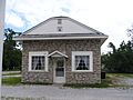
Historic Old Rock filling station on Route 66 in Carterville, MO
-
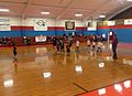
Inside view of Carterville Gymnasium


See also
 In Spanish: Carterville (Misuri) para niños
