Airport Drive, Missouri facts for kids
Quick facts for kids
Airport Drive, Missouri
|
|
|---|---|
|
Village
|
|
| Village of Airport Drive | |

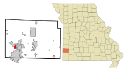
Location of Airport_Drive, Missouri
|
|
| Country | United States |
| State | Missouri |
| County | Jasper |
| Incorporated | 1947 |
| Area | |
| • Total | 2.00 sq mi (5.19 km2) |
| • Land | 2.00 sq mi (5.19 km2) |
| • Water | 0.00 sq mi (0.00 km2) |
| Elevation | 958 ft (292 m) |
| Population
(2020)
|
|
| • Total | 766 |
| • Density | 382.24/sq mi (147.62/km2) |
| Time zone | UTC-6 (Central (CST)) |
| • Summer (DST) | UTC-5 (CDT) |
| FIPS code | 29-00424 |
| GNIS feature ID | 2397919 |
Airport Drive is a small village in Jasper County, Missouri, in the United States. It's a quiet place with a population of 766 people, based on the 2020 census. Even though its official name is Airport Drive, many people still call it "Stone's Corner." This name comes from where two main roads, Route 43 and Route 171, meet. Airport Drive is also part of the larger Joplin, Missouri area.
Contents
About the Area
Airport Drive is a village that covers about 2 square miles (5.19 square kilometers) of land. It doesn't have any large lakes or rivers within its borders.
Weather in Airport Drive
The weather in Airport Drive changes throughout the year, just like in many places.
| Climate data for Airport Drive | |||||||||||||
|---|---|---|---|---|---|---|---|---|---|---|---|---|---|
| Month | Jan | Feb | Mar | Apr | May | Jun | Jul | Aug | Sep | Oct | Nov | Dec | Year |
| Mean daily maximum °F (°C) | 41 (5) |
48 (9) |
57 (14) |
68 (20) |
75 (24) |
84 (29) |
89 (32) |
87 (31) |
80 (27) |
69 (21) |
55 (13) |
46 (8) |
66 (19) |
| Mean daily minimum °F (°C) | 24 (−4) |
28 (−2) |
35 (2) |
46 (8) |
55 (13) |
64 (18) |
68 (20) |
66 (19) |
59 (15) |
48 (9) |
35 (2) |
28 (−2) |
46 (8) |
| Average precipitation inches (mm) | 1.8 (46) |
2.3 (58) |
3.3 (84) |
4 (100) |
4.7 (120) |
5.4 (140) |
3.1 (79) |
3.9 (99) |
5 (130) |
3.7 (94) |
3.2 (81) |
2.6 (66) |
42.9 (1,090) |
| Source: Weatherbase | |||||||||||||
People Living in Airport Drive
The number of people living in Airport Drive has changed over the years.
| Historical population | |||
|---|---|---|---|
| Census | Pop. | %± | |
| 1950 | 225 | — | |
| 1960 | 292 | 29.8% | |
| 1970 | 300 | 2.7% | |
| 1980 | 702 | 134.0% | |
| 1990 | 818 | 16.5% | |
| 2000 | 622 | −24.0% | |
| 2010 | 698 | 12.2% | |
| 2020 | 766 | 9.7% | |
| U.S. Decennial Census | |||
What the 2010 Census Showed
In 2010, there were 698 people living in the village. These people lived in 300 homes, and 203 of those homes were families. On average, about 2 to 3 people lived in each home.
Most of the people in Airport Drive were White (95.7%). A smaller number were Native American, Asian, or from two or more different backgrounds. About 3.4% of the population identified as Hispanic or Latino.
The average age of people in the village was about 43.6 years old. About 20% of the residents were under 18 years old. Around 19% were 65 years or older. The rest were adults between 18 and 64. There were slightly more females (51.4%) than males (48.6%) living in the village.
Schools in the Area
Most students living in Airport Drive go to schools in the Carl Junction R-I School District. A smaller part of the village, on the eastern side, is in the Webb City R-VII School District. Students in the Webb City district usually attend Webb City High School.
See also
 In Spanish: Airport Drive (Misuri) para niños
 | Valerie Thomas |
 | Frederick McKinley Jones |
 | George Edward Alcorn Jr. |
 | Thomas Mensah |

