Crawford County, Kansas facts for kids
Quick facts for kids
Crawford County
|
|
|---|---|

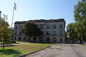
Crawford County Courthouse in Girard (2012)
|
|

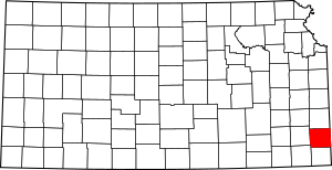
Location within the U.S. state of Kansas
|
|
 Kansas's location within the U.S. |
|
| Country | |
| State | |
| Founded | February 13, 1867 |
| Named for | Samuel J. Crawford |
| Seat | Girard |
| Largest city | Pittsburg |
| Area | |
| • Total | 595 sq mi (1,540 km2) |
| • Land | 590 sq mi (1,500 km2) |
| • Water | 5.3 sq mi (14 km2) 0.9%% |
| Population
(2020)
|
|
| • Total | 38,972 |
| • Estimate
(2021)
|
39,110 |
| • Density | 66.1/sq mi (25.5/km2) |
| Time zone | UTC−6 (Central) |
| • Summer (DST) | UTC−5 (CDT) |
| Area code | 620 |
| Congressional district | 2nd |
Crawford County is a county located in Southeast Kansas. It's like a special area within the state. The main office, called the county seat, is in Girard. The biggest city in the county is Pittsburg.
In 2020, about 38,972 people lived in Crawford County. The county was named after Samuel J. Crawford, who was the third governor of Kansas. You can also find Pittsburg State University here.
History of Crawford County
How Crawford County Began
For thousands of years, the Great Plains of North America were home to nomadic (traveling) Native American tribes. In the 16th to 18th centuries, France claimed a lot of land in North America. But after losing a war to the British in 1762, France secretly gave its land, called New France, to Spain.
In 1802, Spain gave most of this land back to France. Then, in 1803, the United States bought a huge area, including most of what is now Kansas, from France. This was part of the Louisiana Purchase, and it was a really big deal!
In 1854, the Kansas Territory was set up. Six years later, in 1861, Kansas officially became the 34th U.S. state. Before this, there was a lot of fighting about whether Kansas would allow slavery or not. Most people voted for Kansas to be a free state.
Crawford County was created in 1867. It was formed from parts of Bourbon and Cherokee counties. It was named after Samuel J. Crawford, who was the governor at that time.
The 1900s in Crawford County
In the early 1900s, many immigrants came to Crawford County from a part of Europe called the "Little Balkans." They came to work in the mines, which was hard work. Many of these new residents also started small, illegal businesses to earn extra money. The governor of Kansas at the time, Walter R. Stubbs, tried very hard to stop these activities. Even with his efforts, it was tough to completely stop them.
Recent Times: The 2000s
On May 4, 2003, a very strong tornado hit western Crawford County. It started near Frontenac and traveled for about 35 miles (56 km) into Missouri. Towns like Ringo, Franklin, and Mulberry in Crawford County were badly damaged. The tornado was about a quarter-mile wide! Many strong tornadoes hit Kansas and other states that day. The governor at the time, Kathleen Sebelius, said that many areas, including Crawford County, were disaster areas.
Geography
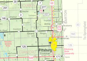
Crawford County covers about 595 square miles (1,541 square kilometers). Most of this is land, with a small part (less than 1%) being water.
Neighboring Counties
Crawford County shares borders with these other counties:
- Bourbon County (north)
- Vernon County, Missouri (northeast)
- Barton County, Missouri (east)
- Jasper County, Missouri (southeast)
- Cherokee County (south)
- Labette County (southwest)
- Neosho County (west)
Population Information
| Historical population | |||
|---|---|---|---|
| Census | Pop. | %± | |
| 1870 | 8,160 | — | |
| 1880 | 16,851 | 106.5% | |
| 1890 | 30,286 | 79.7% | |
| 1900 | 38,809 | 28.1% | |
| 1910 | 51,178 | 31.9% | |
| 1920 | 61,800 | 20.8% | |
| 1930 | 49,329 | −20.2% | |
| 1940 | 44,191 | −10.4% | |
| 1950 | 40,231 | −9.0% | |
| 1960 | 37,032 | −8.0% | |
| 1970 | 37,850 | 2.2% | |
| 1980 | 37,916 | 0.2% | |
| 1990 | 35,568 | −6.2% | |
| 2000 | 38,242 | 7.5% | |
| 2010 | 39,134 | 2.3% | |
| 2020 | 38,972 | −0.4% | |
| 2023 (est.) | 38,764 | −0.9% | |
| U.S. Decennial Census 1790-1960 1900-1990 1990-2000 2010-2020 |
|||
The Pittsburg area, which includes all of Crawford County, is considered a "Micropolitan Statistical Area." This means it's a smaller city area with strong ties to nearby communities.
In 2000, there were 38,242 people living in the county. About 28.5% of households had children under 18. The average age of people in the county was 34 years old.
Education
Colleges and Universities
- Pittsburg State University is a major university located in Pittsburg.
Public School Districts
Here are some of the school districts in Crawford County:
- Northeast USD 246: This district serves the northeast part of the county, including towns like Arcadia and Arma. Their mascot is the Viking!
- Southeast USD 247: This district covers parts of Crawford and Cherokee counties. Southeast High School's mascot is the Lancer.
- Girard USD 248: This district serves Girard and nearby areas. Their mascot is the Trojan.
- Frontenac USD 249: This district serves Frontenac and surrounding communities. Their mascot is the Raider.
- Pittsburg USD 250: This district serves Pittsburg and nearby towns. Their mascot is the Purple Dragon!
Other school districts that have small parts in the county include:
- Chetopa-St. Paul USD 505
- Erie USD 101
- Uniontown USD 235
Private Schools
- Saint Mary's - Colgan is a private Catholic school in Pittsburg for students from kindergarten to 12th grade. Their mascot is the Panther.
Libraries
- Pittsburg Public Library
- Girard Public Library
Communities
Crawford County has several cities and smaller communities.
Cities
- Arcadia
- Arma
- Cherokee
- Frontenac
- Girard (This is the county seat!)
- Hepler
- McCune
- Mulberry
- Pittsburg
- Walnut
Unincorporated Places
These are smaller communities that are not officially cities. Some of them (marked with †) are called "Census-Designated Places" by the U.S. government.
- Beulah
- Brazilton
- Capaldo
- Cato
- Chicopee†
- Coalvale
- Croweburg†
- Curranville
- Dry Wood
- Dunkirk
- Englevale
- Farlington†
- Fleming
- Franklin†
- Fuller
- Greenbush
- Gross
- Kirkwood
- Klondike
- Kniveton‡
- Litchfield
- Lone Oak
- Midway
- Monmouth
- Opolis†
- Polk
- Radley†
- Red Onion
- Ringo†
- South Radley
- Yale†
Townships
Crawford County is divided into nine areas called townships. Some cities are separate from these townships for government purposes. The table below shows information about each township.
| Township | FIPS | Population center |
Population | Population density /km2 (/sq mi) |
Land area km2 (sq mi) |
Water area km2 (sq mi) |
Water % | Geographic coordinates |
|---|---|---|---|---|---|---|---|---|
| Baker | 03750 | Pittsburg | 3,640 | 25 (64) | 147 (57) | 0 (0) | 0.05% | 37°22′57″N 94°42′35″W / 37.38250°N 94.70972°W |
| Crawford | 16250 | Girard | 883 | 6 (14) | 159 (62) | 0 (0) | 0.09% | 37°30′3″N 94°51′13″W / 37.50083°N 94.85361°W |
| Grant | 27575 | 247 | 2 (4) | 145 (56) | 1 (0) | 0.45% | 37°30′10″N 95°1′8″W / 37.50278°N 95.01889°W | |
| Lincoln | 40575 | Arcadia | 942 | 5 (13) | 181 (70) | 0 (0) | 0.23% | 37°37′21″N 94°39′31″W / 37.62250°N 94.65861°W |
| Osage | 53125 | McCune | 756 | 5 (14) | 141 (54) | 1 (0) | 0.44% | 37°22′46″N 95°1′21″W / 37.37944°N 95.02250°W |
| Sheridan | 64675 | Cherokee | 1,501 | 7 (19) | 206 (80) | 1 (0) | 0.31% | 37°22′32″N 94°51′33″W / 37.37556°N 94.85917°W |
| Sherman | 64875 | Farlington | 520 | 3 (7) | 187 (72) | 1 (0) | 0.45% | 37°37′24″N 94°51′35″W / 37.62333°N 94.85972°W |
| Walnut | 74975 | Walnut | 624 | 4 (10) | 166 (64) | 0 (0) | 0.27% | 37°36′15″N 95°1′38″W / 37.60417°N 95.02722°W |
| Washington | 75575 | Frontenac | 3,540 | 23 (59) | 154 (60) | 1 (1) | 0.96% | 37°31′7″N 94°41′44″W / 37.51861°N 94.69556°W |
| Sources: | ||||||||
See also
 In Spanish: Condado de Crawford (Kansas) para niños
 | Victor J. Glover |
 | Yvonne Cagle |
 | Jeanette Epps |
 | Bernard A. Harris Jr. |


