Walnut, Kansas facts for kids
Quick facts for kids
Walnut, Kansas
|
|
|---|---|

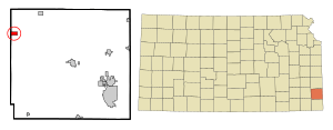
Location within Crawford County and Kansas
|
|

|
|
| Country | United States |
| State | Kansas |
| County | Crawford |
| Founded | 1871 |
| Incorporated | 1874 |
| Named for | Little Walnut Creek |
| Area | |
| • Total | 1.49 sq mi (3.86 km2) |
| • Land | 1.47 sq mi (3.82 km2) |
| • Water | 0.02 sq mi (0.04 km2) |
| Elevation | 929 ft (283 m) |
| Population
(2020)
|
|
| • Total | 187 |
| • Density | 125.5/sq mi (48.45/km2) |
| Time zone | UTC-6 (CST) |
| • Summer (DST) | UTC-5 (CDT) |
| ZIP code |
66780
|
| Area code | 620 |
| FIPS code | 20-74950 |
| GNIS ID | 2397181 |
Walnut is a small city in Crawford County, Kansas, United States. In 2020, about 187 people lived there. It's a quiet place with a rich history.
Contents
History of Walnut
Walnut was first started in 1871. Back then, it had a different name: Glenwood.
In 1874, the town was renamed Walnut. It got its new name from the nearby Little Walnut Creek.
The first post office opened in Walnut in April 1873. For a few years, until April 1877, it was officially called Walnut Station. The town was also served by two important train lines: the Missouri-Kansas-Texas Railroad and the Atchison, Topeka & Santa Fe Railroad.
Where is Walnut?
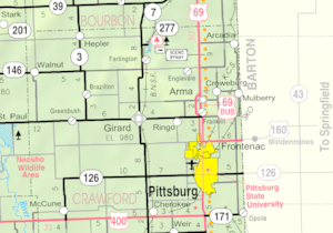
Walnut is located in Kansas. The city covers a total area of about 1.00 square mile (2.59 square kilometers). Most of this area is land, with only a tiny bit being water.
Walnut's Climate
The weather in Walnut has hot and humid summers. Winters are usually mild to cool. This type of weather is known as a humid subtropical climate. On climate maps, you might see it called "Cfa."
People Living in Walnut
| Historical population | |||
|---|---|---|---|
| Census | Pop. | %± | |
| 1880 | 196 | — | |
| 1890 | 539 | 175.0% | |
| 1900 | 603 | 11.9% | |
| 1910 | 639 | 6.0% | |
| 1920 | 650 | 1.7% | |
| 1930 | 553 | −14.9% | |
| 1940 | 544 | −1.6% | |
| 1950 | 534 | −1.8% | |
| 1960 | 381 | −28.7% | |
| 1970 | 330 | −13.4% | |
| 1980 | 308 | −6.7% | |
| 1990 | 214 | −30.5% | |
| 2000 | 221 | 3.3% | |
| 2010 | 220 | −0.5% | |
| 2020 | 187 | −15.0% | |
| U.S. Decennial Census | |||
Walnut's Population in 2010
In 2010, there were 220 people living in Walnut. These people lived in 84 households, and 57 of these were families. The city had about 222 people per square mile. There were also 108 housing units, which are places where people can live.
Most of the people in Walnut were White (96.8%). A small number were Native American (1.8%) or from other backgrounds. About 3.6% of the population was Hispanic or Latino.
Out of the 84 households:
- 40.5% had children under 18 living with them.
- 53.6% were married couples living together.
- About 9.5% had a female head of the household without a husband.
- About 4.8% had a male head of the household without a wife.
- 32.1% were not families, meaning individuals or unrelated people living together.
The average household had 2.62 people, and the average family had 3.26 people.
The average age of people in Walnut was 30.8 years old.
- 34.1% of residents were under 18.
- 5.5% were between 18 and 24.
- 30% were between 25 and 44.
- 21.4% were between 45 and 64.
- 9.1% were 65 or older.
The city's population was almost evenly split between males (49.1%) and females (50.9%).
Walnut's Economy
The main way people make a living in Walnut is through farming. The city's economy is mostly based on agriculture.
See also
 In Spanish: Walnut (Kansas) para niños
 | John T. Biggers |
 | Thomas Blackshear |
 | Mark Bradford |
 | Beverly Buchanan |

