Franklin, Kansas facts for kids
Quick facts for kids
Franklin, Kansas
|
|
|---|---|

|
|
| Country | United States |
| State | Kansas |
| County | Crawford |
| Area | |
| • Total | 1.72 sq mi (4.46 km2) |
| • Land | 1.71 sq mi (4.43 km2) |
| • Water | 0.01 sq mi (0.03 km2) |
| Elevation | 984 ft (300 m) |
| Population
(2020)
|
|
| • Total | 473 |
| • Density | 274.7/sq mi (106.05/km2) |
| Time zone | UTC-6 (CST) |
| • Summer (DST) | UTC-5 (CDT) |
| ZIP code |
66735
|
| Area code | 620 |
| FIPS code | 20-24325 |
| GNIS ID | 2629157 |
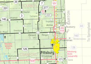
Franklin is a small community in Crawford County, Kansas, in the United States. It is called a census-designated place (CDP) because it's a special area defined for counting people. In 2020, about 473 people lived here. Franklin is located near U.S. Route 69, which is a main road. It's about 1 mile (1.6 km) south of Arma and 5.9 miles (9.5 km) north of Frontenac.
Contents
History of Franklin
Franklin started as a place where people worked in mines in the early 1900s. It was an important spot for shipping goods on the Joplin & Pittsburg electric railroad. This railroad helped move things around the area. The first post office in Franklin opened in 1908, which helped the community grow.
The 2003 Tornado
On May 4, 2003, a very strong F4 tornado hit Franklin. The tornado was over 0.5 miles (0.8 km) wide in some places. Many parts of Franklin were destroyed, including the U.S. Post Office and the community center. About one-third of the homes were also ruined. Four people sadly died, and about 20 people were hurt. The community worked hard to rebuild after this event.
Community Life
Franklin has its own post office with the ZIP code 66735. This helps people send and receive mail.
Places to Visit
Franklin has some interesting places that tell about its history and the surrounding area.
Miners Hall Museum
The Miner's Hall Museum opened on May 1, 2012. Its main goal is to save and show items that tell the story of coal mining in Southeast Kansas. It also shows how mining affected the people who lived there. One special exhibit is about the "Amazon Army." This was a protest in 1921 where thousands of women, including wives, daughters, and mothers of coal miners, stopped work in the mines for three days. They were protesting to support the striking miners.
Franklin Sidewalk
The Franklin Sidewalk was built in 1936 with help from the government. This sidewalk connects two old mining towns in Crawford County: Arma and Franklin. It is 3 feet (0.9 meters) wide and stretches about 1.7 miles (2.7 km) from the south edge of Arma to the south edge of Franklin. It is famous for being the "longest sidewalk connecting two communities." The sidewalk runs next to Business 69 Highway, which is also known as "Jefferson Highway" and the "Frontier Military Scenic Byway." The Franklin Sidewalk was even in the Guinness Book of World Records in the 1950s or 1960s! It was added to the National Register of Historic Places in 2007.
Famous People from Franklin
- Frank Wayenberg, a baseball player
See also
 In Spanish: Franklin (Kansas) para niños
 | Isaac Myers |
 | D. Hamilton Jackson |
 | A. Philip Randolph |


