Bourbon County, Kansas facts for kids
Quick facts for kids
Bourbon County
|
|
|---|---|

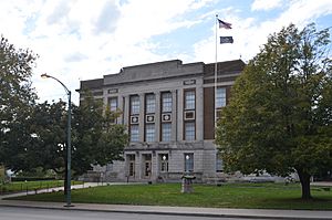
Bourbon County Courthouse in Fort Scott (2016)
|
|

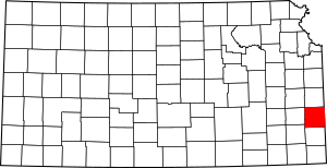
Location within the U.S. state of Kansas
|
|
 Kansas's location within the U.S. |
|
| Country | |
| State | |
| Founded | August 25, 1855 |
| Named for | Bourbon County, Kentucky |
| Seat | Fort Scott |
| Largest city | Fort Scott |
| Area | |
| • Total | 639 sq mi (1,660 km2) |
| • Land | 635 sq mi (1,640 km2) |
| • Water | 3.6 sq mi (9 km2) 0.6%% |
| Population
(2020)
|
|
| • Total | 14,360 |
| • Density | 22.6/sq mi (8.7/km2) |
| Time zone | UTC−6 (Central) |
| • Summer (DST) | UTC−5 (CDT) |
| Area code | 620 |
| Congressional district | 2nd |
Bourbon County is a county located in Southeast Kansas. Its main city and county seat is Fort Scott. This is also its largest city.
In 2020, about 14,360 people lived here. The county was named after Bourbon County, Kentucky. Many early settlers came from that area.
Contents
History of Bourbon County
Early Times
For thousands of years, the Great Plains of North America were home to nomadic Native Americans. They moved around to hunt and gather food.
From the 1500s to the 1700s, the Kingdom of France claimed large parts of North America. This included the area that is now Kansas. In 1762, after a big war, France secretly gave this land to Spain.
The 1800s
In 1802, Spain gave most of the land back to France. But Spain kept about 7,500 square miles.
In 1803, the United States bought most of the land for modern-day Kansas from France. This was part of the huge Louisiana Purchase. The US paid a very small amount per acre for this vast area.
In 1854, the Kansas Territory was set up. Then, in 1861, Kansas became the 34th U.S. state. Just a few years before, in 1855, Bourbon County was officially created.
Recent Discoveries
A new virus, called the Bourbon virus, was first found in Bourbon County. It was named after the county where it was discovered.
Geography of the County
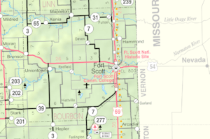
Bourbon County covers about 639 square miles. Most of this area, about 635 square miles, is land. The rest, about 3.6 square miles, is water.
Neighboring Counties
Bourbon County shares borders with these other counties:
- Linn County (to the north)
- Vernon County, Missouri (to the east)
- Crawford County (to the south)
- Neosho County (to the southwest)
- Allen County (to the west)
- Anderson County (to the northwest)
Special Areas
- Fort Scott National Historic Site is a protected area in the county.
Main Roads
Here are some of the major highways that go through Bourbon County:
- U.S. Route 54
- U.S. Route 69
- Kansas Highway 3
- Kansas Highway 7
- Kansas Highway 31
- Kansas Highway 39
- Kansas Highway 65
People in Bourbon County

The population of Bourbon County has changed over the years.
| Historical population | |||
|---|---|---|---|
| Census | Pop. | %± | |
| 1860 | 6,101 | — | |
| 1870 | 15,076 | 147.1% | |
| 1880 | 19,591 | 29.9% | |
| 1890 | 28,575 | 45.9% | |
| 1900 | 24,712 | −13.5% | |
| 1910 | 24,007 | −2.9% | |
| 1920 | 23,198 | −3.4% | |
| 1930 | 22,386 | −3.5% | |
| 1940 | 20,944 | −6.4% | |
| 1950 | 19,153 | −8.6% | |
| 1960 | 16,090 | −16.0% | |
| 1970 | 15,215 | −5.4% | |
| 1980 | 15,969 | 5.0% | |
| 1990 | 14,966 | −6.3% | |
| 2000 | 15,379 | 2.8% | |
| 2010 | 15,173 | −1.3% | |
| 2020 | 14,360 | −5.4% | |
| 2023 (est.) | 14,408 | −5.0% | |
| U.S. Decennial Census 1790–1960 1900–1990 1990–2000 2010–2020 |
|||
In 2000, there were 15,379 people living in the county. There were 6,161 households. Most people were White (94.06%). About 3.08% were Black or African American. Other groups made up smaller parts of the population.
The average household had about 2.44 people. About 30.50% of households had children under 18 living with them. The median age in the county was 38 years old.
Education
Colleges
- Fort Scott Community College is located here.
School Districts
Students in Bourbon County attend schools in these districts:
- Fort Scott USD 234
- Uniontown USD 235
Communities in Bourbon County
Bourbon County has several cities, small towns, and townships.
Cities
Unincorporated Communities
These are smaller communities that are not officially cities. Some are called Census-Designated Places (CDP) by the US Census Bureau.
- Barnesville
- Berlin
- Devon†
- Garland†
- Godfrey
- Hammond
- Harding
- Hiattville
- Marmaton
- Pawnee Station
- Porterville
- Xenia
Townships
Bourbon County is divided into eleven townships. The city of Fort Scott is separate and not included in the township numbers. This table shows information about each township:
| Township | FIPS | Main City | Population | Population density /km2 (/sq mi) |
Land area km2 (sq mi) |
Water area km2 (sq mi) |
Water % | Geographic coordinates |
|---|---|---|---|---|---|---|---|---|
| Drywood | 18750 | 394 | 3 (8) | 120 (47) | 0 (0) | 0.19% | 37°43′19″N 94°40′36″W / 37.72194°N 94.67667°W | |
| Franklin | 24300 | 312 | 2 (4) | 185 (71) | 0 (0) | 0.13% | 37°59′41″N 94°59′14″W / 37.99472°N 94.98722°W | |
| Freedom | 24600 | Fulton | 505 | 4 (12) | 113 (44) | 0 (0) | 0.17% | 38°0′4″N 94°44′45″W / 38.00111°N 94.74583°W |
| Marion | 44650 | Bronson, Uniontown |
1,165 | 4 (12) | 259 (100) | 0 (0) | 0.19% | 37°51′14″N 95°1′12″W / 37.85389°N 95.02000°W |
| Marmaton | 44900 | 815 | 6 (15) | 145 (56) | 0 (0) | 0.13% | 37°48′57″N 94°50′16″W / 37.81583°N 94.83778°W | |
| Mill Creek | 46675 | 472 | 3 (9) | 136 (52) | 1 (0) | 0.42% | 37°54′45″N 94°50′14″W / 37.91250°N 94.83722°W | |
| Osage | 53100 | 394 | 3 (8) | 125 (48) | 0 (0) | 0.16% | 37°58′40″N 94°39′33″W / 37.97778°N 94.65917°W | |
| Pawnee | 54775 | 308 | 2 (6) | 126 (49) | 0 (0) | 0.31% | 37°43′31″N 94°50′30″W / 37.72528°N 94.84167°W | |
| Scott | 63500 | 2,326 | 13 (34) | 179 (69) | 2 (1) | 0.94% | 37°48′35″N 94°41′30″W / 37.80972°N 94.69167°W | |
| Timberhill | 70600 | Mapleton | 256 | 3 (7) | 93 (36) | 0 (0) | 0.05% | 38°0′31″N 94°52′57″W / 38.00861°N 94.88250°W |
| Walnut | 74850 | 135 | 1 (2) | 154 (59) | 0 (0) | 0.13% | 37°43′10″N 94°59′0″W / 37.71944°N 94.98333°W | |
| Sources: | ||||||||
Famous People from Bourbon County
- Richard Christy (born 1974), a drummer and radio personality. He was born and grew up in Bourbon County.
- Jonathan Davis (1871–1943), who became the 22nd Governor of Kansas. He was born in Bourbon County.
- Sarah Hall (1832–1926), who led the Bourbon County Equal Suffrage Association. She lived in Fort Scott for many years.
- Gordon Parks (1912–2006), a famous photographer, composer, author, and film director. He was born in Bourbon County.
See also
 In Spanish: Condado de Bourbon (Kansas) para niños
 | Kyle Baker |
 | Joseph Yoakum |
 | Laura Wheeler Waring |
 | Henry Ossawa Tanner |


