McCune, Kansas facts for kids
Quick facts for kids
McCune, Kansas
|
|
|---|---|

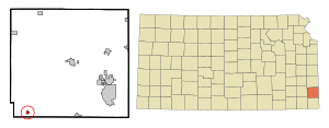
Location within Crawford County and Kansas
|
|

|
|
| Country | United States |
| State | Kansas |
| County | Crawford |
| Founded | 1878 |
| Incorporated | 1881 |
| Named for | Isaac McCune |
| Area | |
| • Total | 0.32 sq mi (0.82 km2) |
| • Land | 0.32 sq mi (0.82 km2) |
| • Water | 0.00 sq mi (0.00 km2) |
| Elevation | 919 ft (280 m) |
| Population
(2020)
|
|
| • Total | 370 |
| • Density | 1,160/sq mi (451/km2) |
| Time zone | UTC-6 (CST) |
| • Summer (DST) | UTC-5 (CDT) |
| ZIP code |
66753
|
| Area code | 620 |
| FIPS code | 20-43725 |
| GNIS ID | 2395063 |
McCune is a small city in Crawford County, Kansas, United States. It's a friendly place with a history tied to the early days of Kansas. As of the 2020 census, about 370 people called McCune home.
Contents
A Look Back: McCune's History
McCune started as a small community in August 1878 when its first post office opened. The town was officially planned out in 1879. It was named after its founder, Isaac McCune. Just two years later, in 1881, McCune became an official city.
McCune was once an important stop on the St. Louis–San Francisco Railway's line to Parsons. The large grain elevator in McCune still stands today. It was the biggest one on this railway line.
Exploring McCune's Geography
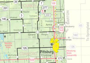
McCune is a compact city. According to the United States Census Bureau, the city covers about 0.31 square miles (0.82 square kilometers). All of this area is land.
McCune's Climate: Hot Summers, Mild Winters
The weather in McCune is known for its hot and humid summers. Winters are usually mild to cool. This type of weather is called a humid subtropical climate. On climate maps, you might see it labeled as "Cfa."
McCune's Population Over Time
| Historical population | |||
|---|---|---|---|
| Census | Pop. | %± | |
| 1880 | 170 | — | |
| 1890 | 700 | 311.8% | |
| 1900 | 657 | −6.1% | |
| 1910 | 736 | 12.0% | |
| 1920 | 591 | −19.7% | |
| 1930 | 584 | −1.2% | |
| 1940 | 556 | −4.8% | |
| 1950 | 532 | −4.3% | |
| 1960 | 433 | −18.6% | |
| 1970 | 487 | 12.5% | |
| 1980 | 528 | 8.4% | |
| 1990 | 462 | −12.5% | |
| 2000 | 426 | −7.8% | |
| 2010 | 405 | −4.9% | |
| 2020 | 370 | −8.6% | |
| U.S. Decennial Census | |||
McCune in 2020: A Snapshot
The 2020 United States census counted 370 people living in McCune. There were 155 households and 104 families. The city had about 1,163 people per square mile.
Most residents, about 88%, were white. About 2.4% were Native American. Around 8.6% of the population identified as being of two or more races. About 1.6% of the people were Hispanic or Latino.
About 34% of households had children under 18. Nearly half, 47.7%, were married couples living together. About 29% of households were single individuals. The average household had 2.2 people. The average family had 3.0 people.
The median age in McCune was 39.6 years. About 23.8% of the population was under 18. About 16.5% of residents were 65 years or older.
McCune in 2010: Looking Back
The census from 2010 showed 405 people living in McCune. There were 169 households and 110 families. The population density was about 1,306 people per square mile.
Most people, 93.6%, were White. About 2.5% were Native American. About 2.7% were from two or more races.
About 35.5% of households had children under 18. Over half, 50.9%, were married couples. About 28.4% of households were individuals living alone. The average household size was 2.40 people.
The median age in 2010 was 39.4 years. About 24.9% of residents were under 18. About 13.6% were 65 years or older.
Education in McCune
McCune is part of USD 247. Students in this area attend Southeast High School. The school's mascot is the Lancers.
McCune used to have its own high school. It was called McCune High School. Its mascot was the McCune Eagles. This school closed when the school districts combined.
See also
 In Spanish: McCune para niños
 | Ernest Everett Just |
 | Mary Jackson |
 | Emmett Chappelle |
 | Marie Maynard Daly |

