
Parsons, Kansas facts for kids
Quick facts for kids
Parsons, Kansas
|
||
|---|---|---|

Former Parsons Carnegie Library, now Parsons Carnegie Arts Center (2013)
|
||
|
||

Location within Labette County and Kansas
|
||

|
||
| Country | United States | |
| State | Kansas | |
| County | Labette | |
| Founded | 1870 | |
| Incorporated | 1871 | |
| Named for | Levi Parsons | |
| Area | ||
| • Total | 10.72 sq mi (27.76 km2) | |
| • Land | 10.63 sq mi (27.54 km2) | |
| • Water | 0.09 sq mi (0.22 km2) | |
| Elevation | 902 ft (275 m) | |
| Population
(2020)
|
||
| • Total | 9,600 | |
| • Density | 896/sq mi (345.8/km2) | |
| Time zone | UTC-6 (CST) | |
| • Summer (DST) | UTC-5 (CDT) | |
| ZIP code |
67357
|
|
| Area code | 620 | |
| FIPS code | 20-54675 | |
| GNIS ID | 469782 | |

Parsons is a city located in Labette County, Kansas, in the United States. In 2020, about 9,600 people lived there. It is the biggest city in Labette County. It is also the second-largest city in the southeastern part of Kansas. Parsons is home to Labette Community College and the Parsons State Hospital & Training Center.
Contents
History of Parsons, Kansas
Parsons was named after Levi Parsons. He was the president of the Missouri–Kansas–Texas Railroad, also known as the Katy Railroad. The city was started in 1870 and became an official city in 1871.
The railroad chose this spot because it was a flat area. It was perfect for two railroad branches to meet. These branches came from Junction City, Kansas and Sedalia, Missouri. Soon, dams were built on nearby creeks for water.
Railroad and Early Growth
The railroad built a huge rail yard, a metal factory, and a train repair shop in Parsons. For many years, this was the third-largest railroad facility west of the Mississippi River. Only Kansas City and Los Angeles had bigger ones.
People from nearby towns moved to Parsons. New settlers arrived on every train. Parsons quickly became a major center for several railroads. These included the Katy Railroad and others.
In the early 1900s, Parsons had its own street car system. It also had an electric train connecting it to nearby cities. These cities included Cherryvale, Independence, Coffeyville, and Nowata.
Parsons During World War II
During World War II, Parsons was home to the Kansas Ordnance Plant. This plant later became the Kansas Army Ammunition Plant. In 2005, the plant was set to close. However, the community worked hard to keep the company, Day & Zimmerman, in the area. This helped save many jobs.
Hospitals and Healthcare
Parsons is home to the Parsons State Hospital & Training Center. It opened in 1903 as the Kansas State Hospital for Epileptics. In 1957, its name changed. It began helping people with developmental disabilities.
The hospital has many buildings on a large piece of land. It offers living services and includes research centers. These centers are for the University of Kansas and Kansas State University.
Parsons also has Labette County Medical Center. This hospital serves the local community.
Public Library History
The first library in Parsons started in 1904. It was a subscription library in the city hall. The Parsons Public Library, a Carnegie library, opened on May 18, 1909.
A new, modern library opened on April 18, 1977. The old Carnegie building was then updated. It is now a center for visual and performing arts.
Changes in Industry
In 1988, the Katy Railroad company was sold. This led to many railroad jobs being lost in Parsons. This was a big change for the city. The city received money to help it recover. This money is used for projects that help the city's economy.
Today, you can still see the railroad tracks. Trains still speed through Parsons. The local history museum and the annual Katy Days Festival remember the railroad's past.
Recent Events (2000-2020)
On April 19, 2000, a strong F3 tornado hit Parsons. It caused a lot of damage in the city center. About 700 homes were damaged, and 100 were destroyed. Many businesses were also affected.
In 2006, Parsons received a special award. The National Trust for Historic Preservation named it a "Great American Main Street Award" winner. This was for its success in making its downtown area better. They did this by preserving old buildings.
Parsons is also home to Dwayne's Photo. This company was the last in the world to develop a special type of film called Kodachrome. Parsons was featured in the 2017 Netflix movie Kodachrome. The movie is about a road trip to develop the last roll of this film.
Filming Location
The movie ZombieGeddon (2003) was filmed in Parsons in July 2002.
Geography and Location
Parsons is located where U.S. Route 59 and U.S. Route 400 meet. The city of Erie is about 17 miles (27 km) north on US-59. Oswego is about 20 miles (32 km) south and east.
There are also several lakes nearby. Big Hill Lake is west of the city. Lake Parsons is northwest.
Kansas Army Ammunition Plant
The Kansas Army Ammunition Plant (KSAAP) is southeast of Parsons. It was finished in 1942 to help with World War II. The plant is very large, covering over 13,727 acres (55.55 km2). It is still used today for loading, assembling, and packing ammunition.
City Area
The city of Parsons covers about 10.70 square miles (27.71 km2) in total. Most of this area, about 10.61 square miles (27.48 km2), is land. The rest, about 0.09 square miles (0.23 km2), is water.
Climate in Parsons
Parsons has a climate with warm summers and mild winters.
| Climate data for Parsons, Kansas | |||||||||||||
|---|---|---|---|---|---|---|---|---|---|---|---|---|---|
| Month | Jan | Feb | Mar | Apr | May | Jun | Jul | Aug | Sep | Oct | Nov | Dec | Year |
| Record high °F (°C) | 77 (25) |
85 (29) |
92 (33) |
98 (37) |
95 (35) |
104 (40) |
115 (46) |
110 (43) |
107 (42) |
97 (36) |
83 (28) |
77 (25) |
115 (46) |
| Mean daily maximum °F (°C) | 42 (6) |
48 (9) |
57 (14) |
67 (19) |
76 (24) |
84 (29) |
90 (32) |
90 (32) |
81 (27) |
70 (21) |
57 (14) |
44 (7) |
67 (20) |
| Mean daily minimum °F (°C) | 22 (−6) |
26 (−3) |
35 (2) |
45 (7) |
55 (13) |
64 (18) |
69 (21) |
67 (19) |
58 (14) |
46 (8) |
35 (2) |
25 (−4) |
46 (8) |
| Record low °F (°C) | −17 (−27) |
−16 (−27) |
−2 (−19) |
18 (−8) |
31 (−1) |
44 (7) |
49 (9) |
47 (8) |
28 (−2) |
17 (−8) |
6 (−14) |
−17 (−27) |
−17 (−27) |
| Average precipitation inches (mm) | 1.41 (36) |
1.85 (47) |
3.19 (81) |
4.38 (111) |
5.93 (151) |
5.53 (140) |
3.92 (100) |
3.29 (84) |
4.69 (119) |
3.86 (98) |
2.94 (75) |
2.06 (52) |
43.05 (1,094) |
| Source: weather.com | |||||||||||||
People of Parsons
| Historical population | |||
|---|---|---|---|
| Census | Pop. | %± | |
| 1880 | 4,199 | — | |
| 1890 | 6,736 | 60.4% | |
| 1900 | 7,682 | 14.0% | |
| 1910 | 12,463 | 62.2% | |
| 1920 | 16,028 | 28.6% | |
| 1930 | 14,903 | −7.0% | |
| 1940 | 14,294 | −4.1% | |
| 1950 | 14,750 | 3.2% | |
| 1960 | 13,929 | −5.6% | |
| 1970 | 13,015 | −6.6% | |
| 1980 | 12,898 | −0.9% | |
| 1990 | 11,924 | −7.6% | |
| 2000 | 11,514 | −3.4% | |
| 2010 | 10,500 | −8.8% | |
| 2020 | 9,600 | −8.6% | |
| U.S. Decennial Census 2010-2020 |
|||
What the 2020 Census Shows
The 2020 census counted 9,600 people in Parsons. There were 4,015 households. About 75% of the people were white. About 8% were Black or African American. Other groups included Native American, Asian, and people of two or more races. About 7% of the population was Hispanic or Latino.
About 29% of households had children under 18. The average household had 2.2 people. The average family had 3.0 people. About 15.6% of people had a college degree or higher.
About 24.9% of the population was under 18 years old. The median age was 37.9 years. This means half the people were younger and half were older than 37.9.
The average income for households was about $41,091. For families, it was about $54,735. About 20.1% of the population lived below the poverty line. This included 24.3% of children under 18.
What the 2010 Census Showed
In 2010, there were 10,500 people living in Parsons. The population density was about 990 people per square mile. About 81.3% of people were White. About 18.6% were African American. About 16.7% of the population was Hispanic or Latino.
About 30.7% of households had children under 18. The average household size was 2.33 people. The average family size was 2.95 people.
The median age in 2010 was 37.8 years. About 24.7% of residents were under 18. About 15.4% were 65 or older.
Arts and Fun Things to Do
Annual Katy Days Festival
The Katy Days is a yearly festival. It happens on Memorial Day weekend. It celebrates the history of the Missouri–Kansas–Texas Railroad, or "the Katy" railroad.
The festival takes place in Forest Park, which is the biggest park in Parsons. You can enjoy live music, food trucks, and a parade.
Schools and Learning
College in Parsons
- Labette Community College
Public Schools
Most of Parsons is served by the Parsons USD 503 public school district:
- Parsons Senior High School (grades 9-12)
- Parsons Middle School (grades 6-8)
- Guthridge Elementary (grades 4-5)
- Garfield Elementary (grades 2-3)
- Lincoln Elementary (Pre-Kindergarten-grade 1)
The southern and western parts of Parsons are served by the Labette County USD 506 public school district:
- Meadow View Elementary (Kindergarten-grade 8)
Erie-Galesburg USD 101 public school district serves areas north of Parsons.
Private Schools
- St. Patrick Catholic School (Pre-Kindergarten-grade 8)
Places to Visit
- Parsons Arboretum
- Tri-City Airport
- Big Hill Lake
- Lake Parsons
- Neosho State Fishing Lake
- Oakwood Cemetery
- Parsons Historical Society Museum
- Forest Park
Famous People from Parsons
- Gilbert Baker, who created the pride flag
- Fred Bradley, a baseball pitcher
- Gil Britton, a baseball player
- Jamie Anne (Brown) Allman, an actress
- Buck Clayton, a jazz musician
- William Coffin Coleman, who started the Coleman Company
- William W. Cranston, a Civil War soldier
- Walter Davidson, Sr., who helped start Harley-Davidson Motor Company
- Pintip Dunn, a young adult fiction author
- Alfred B. Fairfax, a Kansas politician
- Myron V. George, a U.S. congressman
- Derrel Gofourth, an NFL football player
- Bill Guthridge, a college basketball coach
- George Harvey, a professional football player
- Clancy Hayes, a jazz musician
- Shaun Hill, an NFL quarterback
- Ward Kimball, a Disney animator
- Jeff Kready, a Broadway and television actor
- Roland Lakes, an NFL football player
- David J. Leland, a politician and judge
- Deb Miller, a former Kansas Secretary of Transportation
- Ajit Pai, a former FCC Chairman
- George Pepperdine, who started Western Auto and Pepperdine University
- ZaSu Pitts, a film and television actress
- Payne Harry Ratner, a Kansas Governor
- Clyde M. Reed, a Kansas Governor and U.S. Senator
- Nell Donnelly Reed, a businesswoman
- T. Claude Ryan, an aviator and engineer
- Dan Smith, a major league baseball player
- Joe Tinker, a baseball player in the Hall of Fame
- Clark Tippet, a ballet dancer
- Levi Watkins, a heart surgeon
- Ella B. Ensor Wilson, a social reformer
Images for kids
-
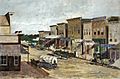
Forest Avenue in 1873, now Broadway Avenue
-
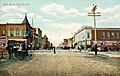
Main Street in 1908
-
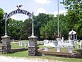
Civil War veterans bought a portion of Oakwood Cemetery in 1886 and named it Antietam Circle


See also
 In Spanish: Parsons (Kansas) para niños
