
Joplin, Missouri facts for kids
Quick facts for kids
Joplin, Missouri
|
||
|---|---|---|

Aerial view of downtown Joplin, 2009. The bridge is 2nd Street and the intersection is 2nd St. and Virginia Ave.
|
||
|
||
| Nickname(s):
"JoMo", "The J", "J-Town", and “Go Town USA”
|
||
| Motto(s):
"The City that Jack Built"
|
||

Joplin, Missouri
Location in Missouri

Joplin, Missouri
Location in the United States
|
||
| Country | United States | |
| State | Missouri | |
| Counties | Jasper, Newton | |
| Incorporated | 1873 | |
| Area | ||
| • City | 38.21 sq mi (98.96 km2) | |
| • Land | 38.08 sq mi (98.63 km2) | |
| • Water | 0.13 sq mi (0.33 km2) | |
| Elevation | 1,004 ft (306 m) | |
| Population
(2020)
|
||
| • City | 51,762 | |
| • Rank | MO: 12th | |
| • Density | 1,359.26/sq mi (524.82/km2) | |
| • Metro | 214,424 (US: 135th) | |
| Demonym(s) | Joplinite | |
| Time zone | UTC−6 (CST) | |
| • Summer (DST) | UTC−5 (CDT) | |
| ZIP codes |
64801-64804
|
|
| Area code | 417 | |
| FIPS code | 29-37592 | |
| GNIS feature ID | 2395482 | |

Joplin is a city located in the southwestern part of the U.S. state of Missouri. Most of the city is in Jasper County, with a smaller part in Newton County. Joplin is the biggest city in both counties. However, it is not the main county town for either. Carthage is the main town for Jasper County, and Neosho is for Newton County.
In 2020, Joplin had a population of 51,762 people. This makes it the 12th largest city in Missouri. The city covers about 35.69 square miles (92.41 km2) and is on the edge of the Ozark Mountains. Joplin is the main center for the three-county Joplin-Miami, Missouri-Oklahoma Metro area, which has over 210,000 people. This makes it the fifth largest metro area in Missouri. In May 2011, a very powerful tornado hit Joplin. It caused a lot of damage and sadly, more than 150 people died.
Contents
Joplin's History: From Mining Town to Modern City
Joplin has a rich history, starting as a mining town and growing into a busy city.
Early Days: How Joplin Began

People found lead in the Joplin Creek Valley before the Civil War. But the area really started to grow after the war. By 1871, many mining camps appeared in the valley. A resident named John C. Cox planned a city on the east side of the valley. He called it Joplin City. This name came from a nearby spring and creek, which were named after Reverend Harris G. Joplin. He settled there around 1840.
Another person, Patrick Murphy from Carthage, planned a city on the other side of the valley. He named it Murphysburg. At first, there was a lot of lawlessness in Joplin because the nearest sheriff was far away. The two cities tried to merge into Union City, but it was found to be against the law. So, they split up. Murphy then suggested they merge again and call the combined city Joplin. They officially merged on March 23, 1873, and have been the City of Joplin ever since.
Mining Boom and Growth
Joplin first became known for lead mining. However, zinc (often called "jack") became the most important mineral. As railroads were built, Joplin connected to bigger markets and grew very quickly. By the early 1900s, Joplin was a major city in the region. Main Street was the center of activity with many shops, hotels, and nice homes. Trolley and train lines made Joplin a central hub for southwest Missouri. It became known as the world's capital for lead and zinc mining.
Mining left its mark on Joplin. There are many open-pit mines and mineshafts. Mining also created piles of ground rock called "tailings piles." These are small hills that some people find unattractive. About 75% of the main part of Joplin has mines underneath it, some more than 100 feet (30 meters) deep. Sometimes, these old mine shafts can collapse, creating sinkholes.
Joplin in the 20th Century

Joplin started to add more cultural places. In 1902, people voted for a tax to build a public library. They also received matching funds to build the Carnegie Library. This library became a symbol of the city's success. In 1930, the large Electric Theater was built, which was a grand movie palace. It was later bought by Fox Theatres and renamed the Fox. After World War II, fewer people went to big movie theaters.
After World War II, most of the mines closed. The city's population growth slowed down. The main road through Joplin, running east and west, became part of U.S. Route 66. This highway became very famous as more Americans traveled by car.
In the 1960s and 1970s, about 40 acres (16 hectares) of downtown Joplin were torn down. This was part of a plan to make the city new again, as people and businesses had moved to areas along the new highways. Some important historic buildings were lost. However, the Christman's Department Store (now apartments) and the Joplin Union Depot still stand. Other notable historic buildings include the Carnegie Library, Fred and Red's Diner, the Frisco Depot, and the Scottish Rite Cathedral. The Newman Mercantile Store is now City Hall. The Fox Theatre is now the Central Christian Center.
On May 5, 1971, a strong tornado hit Joplin. One person died, and 50 were hurt. Many homes and businesses were damaged. On November 11, 1978, the historic Connor Hotel collapsed early during demolition. Two workers died, and one was trapped for four days but survived.
Joplin in the 21st Century
Joplin now has two main hospitals that serve the region: Freeman-Oak Hill Hospital Health System and Mercy Hospital Joplin. Mercy Hospital Joplin replaced St. John's Regional Medical Center, which was destroyed in the 2011 tornado. The city's park system has almost 1,000 acres (400 hectares). It includes a golf course, swimming pools, and 15 miles (24 km) of walking and biking trails. Wildcat Park has unique Chert Glades and the Shoal Creek Nature Center. Grand Falls, the tallest continuously flowing waterfall in Missouri, is on Shoal Creek at the city's southern end.
Many buildings in Joplin are listed on the National Register of Historic Places. The city has worked to improve its downtown area, which is on historic Route 66. They have fixed up building fronts, sidewalks, and added old-style lamp posts and benches. A trolley system also helps people get around downtown.
Many trucking companies, like CFI, have their main offices in Joplin. This is because the city is located near the center of the country. Other important employers include Eagle-Picher Industries, Tamko Building Products, AT&T Communications, and Schaeffler Group. Leggett & Platt, a large company, is in nearby Carthage. The city is served by the Joplin Regional Airport, north of town.
Since the 2011 tornado, Joplin has grown eastward towards I-44. A lot of new buildings have appeared along Range Line Road, especially near Northpark Mall. Many smaller cities are also close to Joplin, such as Carl Junction and Webb City.
Joplin is a popular place for travelers and events because of its location near major highways and its event facilities. It has nearly 500 hotel rooms. The John Q. Hammons Convention and Trade Center is a large facility for conventions and events.
Every June, Joplin hosts the Boomtown Run. This event includes a half marathon, a 5K race, and a children's run. Runners from all over the country come to participate. In 2011, after the tornado, the event became the Boomtown Run Day of Service. Runners and volunteers helped clean up and sort donations, giving over 1,200 hours of service.
The 2011 Joplin Tornado


On May 22, 2011, a very powerful tornado hit Joplin. It formed around 5:21 p.m. CDT and moved across the city. The tornado's path of damage was up to 1 mile (1.6 km) wide and 22.1 miles (35.6 km) long. The six miles through Joplin had the worst damage. About 2,400 houses, 1,000 cars, and many businesses were destroyed. The tornado just missed the downtown area.
St. John's Regional Medical Center was badly damaged and later torn down. A temporary hospital was set up until a new permanent one could be built. Joplin High School was also completely destroyed. By the end of July 2011, 161 people had died from tornado-related injuries. Power and communication were lost in many areas. The National Weather Service said the tornado was an EF5, the strongest type of tornado.
On May 29, President Barack Obama, Missouri Governor Jay Nixon, and Federal Emergency Management Agency Director Craig Fugate visited Joplin. They toured the damaged areas and attended a memorial service. Later that day, the city held a moment of silence at 5:41 p.m., the exact time the tornado struck. The area was declared a federal disaster area.
After the tornado, the city worked on rebuilding. They hired a company to help with reconstruction efforts. Important projects included rebuilding homes and facilities for seniors. About 7,500 homes were damaged or destroyed. The city also received government funds for new projects like a new public library and a senior center. These projects aimed to help the city grow and improve. The Economic Development Administration gave $20 million to build the new Joplin Library. They also provided funds for a disaster recovery coordinator.
In 2012 and 2013, the United States Housing and Urban Development Department gave large grants for rebuilding. In 2013, the Missouri Department of Natural Resources gave $500,000 to help restore the city's trees. About 1,500 large trees were planted in the tornado zone.
In May 2016, a "Joplin Disaster Recovery Summit" was held to make sure recovery plans continued. By March 2018, the new hospital, schools, and public library were finished. Mercy Park was created where the old hospital used to be.
Tourism and Art in Joplin
After the 2011 tornado, many unofficial murals and monuments appeared in Joplin. These showed the community's strong spirit to rebuild. This also marked the beginning of an art movement in Joplin that continues today. One example was the Rainbow Tree on 20th Street. This tree was damaged in the tornado, and the community decorated it with birdhouses, paint, and a sign. It has since been removed.
Butterflies became a big part of the art in the city. This was because of stories from children who said they saw butterfly-like figures helping people after the tornado. One of the first artworks with butterflies was the "Butterfly Effect: Dreams Take Flight" Mural. It is on the northwest corner of 15th and Main Street. Dave Loewenstein painted it with help from community members and over 300 volunteers.

In March 2018, Joplin studied its tourism to find ways to improve. They wanted to make visitors' experiences better, attract more people, and increase spending. One idea was to build a conference center with a hotel. Another was to improve downtown by adding more hotels, supporting local markets, and promoting arts and entertainment.
In September 2019, Joplin opened the Rotary Sculpture Garden in Mercy Park. It has 9 new sculptures, with more planned. The Joplin Rotary Club and Joplin Daybreak Rotary Club worked together on this project. The sculptures were donated by community members.
Joplin's history, especially its mining past, is celebrated at the Joplin History and Mineral Museum. It is in Schifferdecker Park. The museum has sections on local history and minerals from around the world. Outside, you can see old mining equipment used in the Joplin area.
The Spooklight, a mysterious orb that locals and tourists report seeing, is also located in the region around Joplin.
Joplin's Geography and Climate
Joplin is located in what is known as the Four State Area. This area includes parts of Oklahoma, Arkansas, Missouri, and Kansas. Joplin is north of I-44, which goes west into Oklahoma. In recent years, Joplin has grown north towards Webb City. The historic U.S. Route 66 (now decommissioned) passes through Joplin as 7th Street.
The city has several creeks, including Joplin, Turkey, Silver, and Shoal creeks.
The United States Census Bureau says Joplin covers about 35.68 square miles (92.41 km2). Most of this is land, with a small amount of water.
Joplin's Neighborhoods
Joplin has many neighborhoods, including Roanoke, Arbor Hills, Blendville, Gateway Drive, Iron Gates, Eastmorland, Midway, Murphysburg, North Heights, Oak Pointe, Royal Heights, Silver Creek, Sunnyvale, Sunset Ridge, Westberry Square, and Cedar Ridge.
Joplin's Weather and Climate
Joplin has a humid subtropical climate. This means it has cool, dry winters and hot, humid summers. The severe weather season, from April to June, is the wettest time of year. The average daily temperature in January is 34.9°F (1.6°C) and in July is 79.9°F (26.6°C). On average, Joplin has about 52 days a year where the temperature reaches 90°F (32°C) or higher. It also has about 12 days where the high temperature stays below freezing. The city gets about 45.58 inches (115.8 cm) of rain each year, and about 12.5 inches (31.8 cm) of snow.
Joplin is located in Tornado Alley. This means it is an area where tornadoes are common. Besides the 2011 EF5 tornado, an F3 tornado also hit the city in 1971.
| Climate data for Joplin Regional Airport, Missouri (1991–2020 normals, extremes 1902–present) | |||||||||||||
|---|---|---|---|---|---|---|---|---|---|---|---|---|---|
| Month | Jan | Feb | Mar | Apr | May | Jun | Jul | Aug | Sep | Oct | Nov | Dec | Year |
| Record high °F (°C) | 79 (26) |
87 (31) |
94 (34) |
96 (36) |
96 (36) |
104 (40) |
115 (46) |
110 (43) |
105 (41) |
94 (34) |
87 (31) |
76 (24) |
115 (46) |
| Mean daily maximum °F (°C) | 44.8 (7.1) |
50.0 (10.0) |
59.8 (15.4) |
69.2 (20.7) |
77.0 (25.0) |
85.9 (29.9) |
90.3 (32.4) |
90.0 (32.2) |
82.0 (27.8) |
70.7 (21.5) |
58.4 (14.7) |
47.8 (8.8) |
68.8 (20.4) |
| Daily mean °F (°C) | 34.9 (1.6) |
39.4 (4.1) |
48.6 (9.2) |
57.9 (14.4) |
66.5 (19.2) |
75.6 (24.2) |
79.9 (26.6) |
79.0 (26.1) |
70.7 (21.5) |
59.3 (15.2) |
47.8 (8.8) |
38.1 (3.4) |
58.1 (14.5) |
| Mean daily minimum °F (°C) | 25.0 (−3.9) |
28.7 (−1.8) |
37.4 (3.0) |
46.6 (8.1) |
56.0 (13.3) |
65.3 (18.5) |
69.5 (20.8) |
67.9 (19.9) |
59.4 (15.2) |
47.9 (8.8) |
37.1 (2.8) |
28.5 (−1.9) |
47.4 (8.6) |
| Record low °F (°C) | −12 (−24) |
−21 (−29) |
−5 (−21) |
19 (−7) |
30 (−1) |
44 (7) |
50 (10) |
46 (8) |
30 (−1) |
18 (−8) |
6 (−14) |
−15 (−26) |
−21 (−29) |
| Average precipitation inches (mm) | 1.92 (49) |
1.98 (50) |
3.29 (84) |
4.99 (127) |
6.56 (167) |
5.60 (142) |
3.97 (101) |
3.36 (85) |
4.18 (106) |
3.80 (97) |
3.33 (85) |
2.60 (66) |
45.58 (1,158) |
| Average snowfall inches (cm) | 4.7 (12) |
3.5 (8.9) |
1.1 (2.8) |
0.0 (0.0) |
0.0 (0.0) |
0.0 (0.0) |
0.0 (0.0) |
0.0 (0.0) |
0.0 (0.0) |
0.0 (0.0) |
0.4 (1.0) |
2.8 (7.1) |
12.5 (32) |
| Average precipitation days (≥ 0.01 in) | 7.7 | 6.7 | 10.1 | 11.0 | 12.5 | 10.2 | 8.5 | 7.5 | 7.6 | 8.8 | 7.8 | 7.7 | 106.1 |
| Average snowy days (≥ 0.1 in) | 2.6 | 2.0 | 0.9 | 0.1 | 0.0 | 0.0 | 0.0 | 0.0 | 0.0 | 0.1 | 0.3 | 2.3 | 8.3 |
| Source: NOAA (snow 1981–2010) | |||||||||||||
Joplin's Population and People
| Historical population | |||
|---|---|---|---|
| Census | Pop. | %± | |
| 1880 | 7,038 | — | |
| 1890 | 9,943 | 41.3% | |
| 1900 | 26,023 | 161.7% | |
| 1910 | 32,073 | 23.2% | |
| 1920 | 29,902 | −6.8% | |
| 1930 | 33,454 | 11.9% | |
| 1940 | 37,144 | 11.0% | |
| 1950 | 38,711 | 4.2% | |
| 1960 | 38,958 | 0.6% | |
| 1970 | 39,256 | 0.8% | |
| 1980 | 39,126 | −0.3% | |
| 1990 | 40,961 | 4.7% | |
| 2000 | 45,504 | 11.1% | |
| 2010 | 50,150 | 10.2% | |
| 2020 | 51,762 | 3.2% | |
| 2023 (est.) | 53,095 | 5.9% | |
| U.S. Decennial Census 2018 Estimate |
|||
Population in 2020
The 2020 United States census counted 51,762 people living in Joplin. There were 21,012 households and 11,973 families. The population density was about 1,359 people per square mile (525 per km2). There were 23,851 housing units.
Most of the people in Joplin were white (79.76%). Other groups included black or African-American (3.21%), Native American (2.13%), and Asian (1.91%). About 6.4% of the population was Hispanic or Latino.
About 24.9% of households had children under 18. About 40.7% were married couples. The average household had 2.3 people, and the average family had 3.0 people.
About 21.7% of the population was under 18 years old. About 17.5% were 65 years or older. The average age in Joplin was 36.6 years.
Population in 2010
In the 2010 census, Joplin had 50,150 people. There were 20,860 households and 12,212 families. The population density was about 1,448 people per square mile (559 per km2).
The racial makeup was 87.6% White, 3.3% African American, 1.8% Native American, and 1.6% Asian. About 4.5% of the population was Hispanic or Latino.
About 24.6% of households had children under 18. The average household size was 2.28 people, and the average family size was 2.89 people.
About 24.21% of the population was under 19 years old. The median age was 35 years.
Joplin's Economy and Jobs
Joplin has a strong economy with many different types of businesses.
Major Employers in Joplin
Here are some of the top employers in Joplin, based on a 2019 report:
| # | Employer | # of employees |
|---|---|---|
| 1 | Freeman Health System | 4,500 |
| 2 | Walmart | 2,400 |
| 3 | Mercy Hospital Joplin | 1,538 |
| 4 | Joplin School District | 1,480 |
| 5 | Tri-State Motor Transit | 1,135 |
| 6 | Tamko Building Products | 1,000 |
| 7 | Empire District Electric Company | 896 |
| 8 | Eagle-Picher | 778 |
| 9 | Alorica | 595 |
| 10 | City of Joplin | 585 |
| 11 | CFI | 567 |
| 12 | Ozark Center | 567 |
| 13 | Missouri Southern State University | 560 |
| 14 | General Mills | 490 |
| 15 | AT&T Mobility | 448 |
| 16 | Jasper Products | 399 |
| 17 | Teleperformance (Aegis Communications) | 350 |
| 18 | Schaeffler Group | 310 |
| 19 | Bemis Company | 275 |
| 20 | Hampshire Pet Products | 245 |
Education in Joplin: Schools and Colleges
Joplin offers many choices for education, from elementary schools to universities.
Schools for Younger Students
Most of Joplin is part of the Joplin R-VIII School District. This district has 10 public elementary schools: Cecil Floyd, Dover Hill, Eastmorland, Irving, Jefferson, Kelsey Norman, McKinley, Royal Heights, Soaring Heights, and Stapleton. There are also three public middle schools (East, North, and South) and one high school, Joplin High School. The first high school was built in 1885. In the 2008–2009 school year, Joplin High School had almost 2,200 students. In 2007, voters approved money to build two new middle schools and make North Middle School much larger.
Some parts of Joplin are in other school districts, like Webb City R-VII School District and Carl Junction R-I School District.
Joplin also has many private schools. These include New Heights Christian Academy, Martin Luther School, Thomas Jefferson Independent Day School, and Christ's Community Discovery School. There are also Catholic schools: St. Mary's Catholic Elementary School, St. Peter's Middle School, and McAuley Catholic High School, which were started in 1885.
Missouri Schools for the Severely Disabled (MSSD) helps students with severe disabilities in the Joplin area at College View State School.

Colleges and Universities
Joplin is home to Missouri Southern State University, which started in 1937 as a junior college and grew over time. There is also Ozark Christian College, a Bible college.
In 2015, Kansas City University of Medicine and Biosciences announced they would open a campus in Joplin. This campus has a large program for osteopathic medicine. It is located near where the old St. John's Regional Medical Center used to be. In 2017, KCU welcomed its first class. The campus has a large lecture hall and labs. KCU-Joplin also works with Freeman Health Systems and Mercy Hospital Joplin.
Joplin also has technical schools like Franklin Technology Center and WTI.
Joplin Public Library
The city has the Joplin Public Library. In 2013, the Economic Development Administration gave the city $20 million to move the old library to a new building. This new library is on 20th Street, in the area hit by the tornado. In June 2017, the new, modern 48,000 square foot (4,459 m2) library opened. It cost almost $20 million. The new library has meeting rooms, an outdoor plaza, and areas for children, teens, and adults. It also has spaces and equipment for creative arts and business ideas.
Transportation in Joplin
Joplin is a hub for transportation, with trains, highways, and an airport.
Joplin is served by the main line of the Kansas City Southern (KCS) railroad. It also has lines from the BNSF Railway and Missouri and Northern Arkansas Railroad (MNA). Joplin used to be very busy with trains, but many lines closed after mining ended. Passenger trains stopped serving the city in the 1960s. The Joplin Union Depot is still standing, and people are working to restore it.
Interstate 44 connects Joplin to Springfield and St. Louis to the east. To the west, it connects to Tulsa and Oklahoma City. U.S. Route 71 runs east of the city, connecting Joplin to Kansas City in the north and Fort Smith, Arkansas, in the south. The part of U.S. Route 71 from Kansas City to Joplin became Interstate 49 in 2012.
Range Line Road is the main north-south commercial area. It sees about 25,000 vehicles every day. In 2022, the Range Line Road bridge over the Kansas City Southern Railroad line was replaced to be taller and wider for future growth.
Joplin once had a large trolley system. Today, part of the city is served by the Sunshine Lamp Trolley, which started in 2007.
The Joplin Regional Airport offers daily flights to Denver international airport and Chicago-O'Hare International Airport. These flights are operated by United Express as United Airlines.
Bus service to the city is provided by Greyhound Lines and Jefferson Lines.
Notable People from Joplin


Many well-known people have connections to Joplin, Missouri.
- John Beal, actor
- Emily Newell Blair, writer, suffragist, and a founder of the League of Women Voters
- Betty Brewer, actress
- Norma Lee Clark, author
- Robert Cummings, actor, known for films and TV shows like The Bob Cummings Show
- Pauline Donnan, opera singer
- Christofer Drew, musician
- Scott Elbert, Major League Baseball pitcher
- Glen Glenn, singer
- Jane Grant, co-founder of The New Yorker magazine
- Langston Hughes, famous poet and writer
- Hale Irwin, golfer, who won the U.S. Open three times
- Jack Jewsbury, former player and captain for the Portland Timbers soccer team
- Tito Landrum, baseball player
- Charles McCord, retired broadcaster and writer
- Jamie McMurray, NASCAR driver
- Charles McPherson, jazz musician
- Elva Miller, singer
- Victor J. Miller, 33rd Mayor of St. Louis
- Lisa Myers, broadcast journalist
- J. Eddie Peck, actor, who grew up in Joplin
- Charles Plumb, cartoonist who created Ella Cinders
- Carl Pomerance, mathematician
- Darrell Porter, baseball player, World Series champion
- Vance Powell, Grammy winning record producer
- Mel Purcell, tennis player
- Ron Richard, former Mayor of Joplin and Missouri State Senator
- Lane Roberts, Missouri State Representative and former Joplin Police Chief
- Pattiann Rogers, poet
- Wayne Shanklin, music producer and songwriter
- Frank Shellenback, baseball pitcher
- Pauline Starke, silent-film actress
- Gabby Street, manager of the St. Louis Cardinals
- William Tobin, journalist
- Dennis Weaver, actor, known for Gunsmoke and McCloud
- Travis Webb, racing driver
- Percy Wenrich, composer
- Bill White, Missouri State Senator
- Grant Wistrom, former NFL defensive end, Super Bowl champion
- Grace Steele Woodward, writer and historian
Images for kids
-
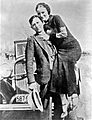
Bonnie and Clyde, photo developed by the Joplin Globe after the shootout
-
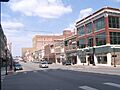
Historic district at 6th and Main, looking north, 2010


See also
 In Spanish: Joplin (Misuri) para niños
