Thayer, Kansas facts for kids
Quick facts for kids
Thayer, Kansas
|
|
|---|---|

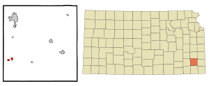
Location within Neosho County and Kansas
|
|

|
|
| Country | United States |
| State | Kansas |
| County | Neosho |
| Founded | 1870 |
| Platted | 1870 |
| Incorporated | 1871 |
| Named for | Nathaniel Thayer |
| Area | |
| • Total | 0.80 sq mi (2.07 km2) |
| • Land | 0.75 sq mi (1.95 km2) |
| • Water | 0.05 sq mi (0.12 km2) |
| Elevation | 1,024 ft (312 m) |
| Population
(2020)
|
|
| • Total | 432 |
| • Density | 540/sq mi (208.7/km2) |
| Time zone | UTC-6 (CST) |
| • Summer (DST) | UTC-5 (CDT) |
| ZIP code |
66776
|
| Area code | 620 |
| FIPS code | 20-70300 |
| GNIS ID | 2396047 |
Thayer is a small city located in Neosho County, Kansas, in the United States. In 2020, about 432 people lived there. It's a quiet place with a rich history.
Contents
History of Thayer
Thayer was first planned out in the fall of 1870. This happened when the railroad lines were built to reach that spot. The city was named after Nathaniel Thayer, who worked for the railroad company. The town grew very quickly. It officially became a city in 1871.
Geography and Climate
Where is Thayer?
According to the United States Census Bureau, Thayer covers a total area of about 0.80 square miles (2.07 square kilometers). Most of this area, about 0.75 square miles (1.95 square kilometers), is land. A small part, about 0.05 square miles (0.12 square kilometers), is water.
Thayer's Weather
The weather in Thayer has hot and humid summers. Winters are usually mild to cool. This type of weather is known as a humid subtropical climate. On climate maps, you might see it called "Cfa."
People of Thayer
| Historical population | |||
|---|---|---|---|
| Census | Pop. | %± | |
| 1880 | 311 | — | |
| 1890 | 544 | 74.9% | |
| 1900 | 542 | −0.4% | |
| 1910 | 542 | 0.0% | |
| 1920 | 528 | −2.6% | |
| 1930 | 495 | −6.2% | |
| 1940 | 461 | −6.9% | |
| 1950 | 423 | −8.2% | |
| 1960 | 396 | −6.4% | |
| 1970 | 430 | 8.6% | |
| 1980 | 517 | 20.2% | |
| 1990 | 435 | −15.9% | |
| 2000 | 500 | 14.9% | |
| 2010 | 497 | −0.6% | |
| 2020 | 432 | −13.1% | |
| U.S. Decennial Census | |||
Who Lives Here?
In 2010, a census showed that 497 people lived in Thayer. There were 197 households and 136 families. The city had about 662.7 people per square mile. There were 221 homes available.
Most people in Thayer (95.6%) were White. A small number were Native American (0.8%) or Asian (0.2%). About 3.4% of residents were from two or more racial backgrounds. About 1.8% of the population was Hispanic or Latino.
About 34.5% of homes had children under 18 living there. Most households (57.9%) were married couples. Some homes had a female head (6.1%) or a male head (5.1%) without a spouse. About 31.0% of households were not families. Also, 27.4% of homes had only one person living there. About 11.2% of these single-person homes had someone 65 or older.
The average household had 2.52 people. The average family had 3.05 people. The average age in the city was 37.1 years old. About 25.8% of residents were under 18. Another 14.5% were 65 or older. The city had slightly more males (53.7%) than females (46.3%).
Education
Students in Thayer attend schools in USD 447 Cherryvale. Thayer High School used to be open. However, it closed due to school unification, which means schools in the area joined together. The mascot for Thayer schools was the Flyer.
Famous People from Thayer
- Nellie Shepherd, a well-known painter.
See also
 In Spanish: Thayer (Kansas) para niños
 | Janet Taylor Pickett |
 | Synthia Saint James |
 | Howardena Pindell |
 | Faith Ringgold |

