Petrolia, Kansas facts for kids
Quick facts for kids
Petrolia, Kansas
|
|
|---|---|

|
|
| Country | United States |
| State | Kansas |
| County | Allen |
| Elevation | 955 ft (291 m) |
| Time zone | UTC-6 (CST) |
| • Summer (DST) | UTC-5 (CDT) |
| ZIP code |
66720
|
| Area code | 620 |
| FIPS code | 20-55625 |
| GNIS ID | 474962 |
Petrolia is a small, unincorporated community located in Allen County, Kansas, United States. It is found right next to the Neosho River.
History of Petrolia
In 1910, Petrolia was a busy place. It had a post office where people could send money orders. There was also an express office for sending packages. The community was a main trading spot for people living nearby. About 200 people lived in Petrolia that year.
Petrolia had its own post office for many years. It opened in July 1905 and closed in September 1953.
Where is Petrolia?
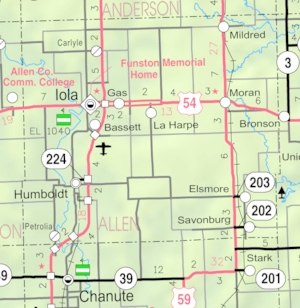
Petrolia is located in the southern part of Allen County, Kansas. It sits west of the Neosho River and south of a smaller stream called Scatter Creek. The community is entirely within Logan Township.
Petrolia is about 5 miles south-southwest of Humboldt. It is also about 13 miles from Iola, which is the main town and county seat of Allen County. U.S. Route 169, a major road, crosses the Neosho River about a mile south of Petrolia.
Schools in Petrolia
The public schools for children in Petrolia are part of the Chanute USD 413 school district.
 | James Van Der Zee |
 | Alma Thomas |
 | Ellis Wilson |
 | Margaret Taylor-Burroughs |


