La Harpe, Kansas facts for kids
Quick facts for kids
La Harpe, Kansas
|
|
|---|---|

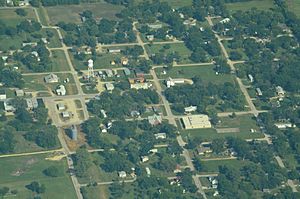
Aerial View of La Harpe (2013)
|
|

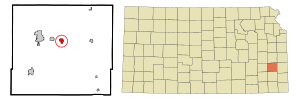
Location within Allen County and Kansas
|
|

|
|
| Country | United States |
| State | Kansas |
| County | Allen |
| Founded | 1881 |
| Platted | 1881 |
| Incorporated | 1905 |
| Named for | La Harpe, Illinois |
| Area | |
| • Total | 0.80 sq mi (2.08 km2) |
| • Land | 0.80 sq mi (2.08 km2) |
| • Water | 0.00 sq mi (0.00 km2) |
| Elevation | 1,030 ft (310 m) |
| Population
(2020)
|
|
| • Total | 480 |
| • Density | 600/sq mi (230.8/km2) |
| Time zone | UTC-6 (CST) |
| • Summer (DST) | UTC-5 (CDT) |
| ZIP code |
66751
|
| Area code | 620 |
| FIPS code | 20-37725 |
| GNIS ID | 485604 |
La Harpe is a small city in Allen County, Kansas, in the United States. In 2020, about 480 people lived there.
Contents
History of La Harpe
La Harpe was started by a railroad company in 1881. It was carefully planned out, which is called "platted." The city got its name from La Harpe, Illinois. Both places are named after Bernard de la Harpe, a famous French explorer. He explored the southern Great Plains of North America a long time ago.
Growth of the City
In 1899, people found natural gas nearby. This discovery helped La Harpe grow very quickly. It became an important city. By 1910, La Harpe was home to some of the biggest zinc smelters in the world. Zinc smelters are factories that melt zinc ore to get pure zinc.
The city also had two banks and an opera house. There were many good shops and a newspaper. La Harpe had all the services a city needed back then. In 1910, the population reached 2,080 people. The local post office could even send money orders to other countries. Mail was also delivered to the countryside nearby.
Geography of La Harpe
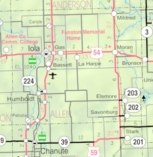
La Harpe is located in the middle of Allen County. It is found along U.S. Route 54, a major highway. The city is about 5.5 miles (8.8 km) east of Iola. Iola is the main city of Allen County.
La Harpe is also about 2.5 miles (4 km) east of Gas. It is about seven miles (11 km) west of Moran. According to the United States Census Bureau, La Harpe covers an area of 0.82 square miles (2.12 square kilometers). All of this area is land.
Population Changes in La Harpe
The number of people living in La Harpe has changed over the years. Here is a look at the population from different census counts:
| Historical population | |||
|---|---|---|---|
| Census | Pop. | %± | |
| 1900 | 610 | — | |
| 1910 | 2,080 | 241.0% | |
| 1920 | 1,001 | −51.9% | |
| 1930 | 756 | −24.5% | |
| 1940 | 624 | −17.5% | |
| 1950 | 511 | −18.1% | |
| 1960 | 529 | 3.5% | |
| 1970 | 509 | −3.8% | |
| 1980 | 687 | 35.0% | |
| 1990 | 650 | −5.4% | |
| 2000 | 706 | 8.6% | |
| 2010 | 578 | −18.1% | |
| 2020 | 480 | −17.0% | |
| U.S. Decennial Census | |||
2020 Census Information
The 2020 United States census counted 480 people living in La Harpe. There were 207 households and 133 families. Most people were white or European American. About 19.8% of the people were under 18 years old. The median age in the city was 44.7 years. This means half the people were younger than 44.7 and half were older.
2010 Census Information
In 2010, the census showed that 578 people lived in La Harpe. There were 234 households. The average number of people in a household was 2.47. The average family size was 2.91 people. The median age in the city was 42.2 years. About 22.3% of the people were under 18 years old.
Education in La Harpe
La Harpe is part of the USD 257 Iola school district. The high school for this district is Iola High School. Their sports teams are called the Mustangs.
La Harpe used to have its own schools. However, these schools were closed when the school districts combined. The old La Harpe High School mascot was the Panthers.
Notable People from La Harpe
- Ad Brennan, a baseball player
See also
 In Spanish: La Harpe (Kansas) para niños
 | James Van Der Zee |
 | Alma Thomas |
 | Ellis Wilson |
 | Margaret Taylor-Burroughs |

