
Sac River facts for kids
Quick facts for kids Sac River |
|
|---|---|

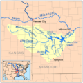
Map of the Osage River watershed showing the Sac River
|
|
| Country | United States |
| State | Missouri |
| Physical characteristics | |
| Main source | Greene County, Missouri 1,240 ft (380 m) 37°12′39″N 93°26′04″W / 37.21083°N 93.43444°W |
| River mouth | Truman Reservoir Osceola, Missouri 709 ft (216 m) 38°01′00″N 93°43′08″W / 38.01667°N 93.71889°W |
| Length | 118 mi (190 km) |
| Basin features | |
| Basin size | 1,981 sq mi (5,130 km2) |
| Tributaries |
|
| Watersheds | Sac-Osage-Missouri-Mississippi |
The Sac River is a river located in the Ozarks region of Southwest Missouri, United States. It flows for about 118 mi (190 km), which is roughly the distance from New York City to Philadelphia!
The river starts in western Greene County. It then winds its way through several other counties. These include Lawrence County, Dade County, Cedar County, and St. Clair County. Finally, it joins the Osage River in the Truman Reservoir near Osceola.
Contents
What is the Sac River?
The Sac River is an important waterway in Missouri. It's known for its winding path and the beautiful areas it flows through. The river is a key part of the local environment.
Where Does the Sac River Flow?
The Sac River begins in Greene County, Missouri. Its journey takes it through different parts of the Ozarks. It passes through the northeast corner of Lawrence County. Then, it goes back into Greene County.
Next, the river enters Dade County near Ash Grove. A big part of the river flows into Stockton Lake. This lake is located between Dadeville and Greenfield.
Sac River's Path Through Lakes and Counties
After Stockton Lake, the Sac River continues north. It leaves the lake in Cedar County. The river then flows into St. Clair County. It goes under U.S. Route 54. Finally, it reaches the Truman Reservoir. Here, it joins the Osage River.
How Big is the Sac River?
The Sac River is about 118 mi (190 km) long. This makes it a medium-sized river in the region. Its waters come from a large area called a watershed. The Sac River's watershed covers about 1,981 sq mi (5,130 km2). That's a huge area, almost the size of the state of Delaware!
A smaller river, the Little Sac River, also flows into the Sac River. Both the Sac River and the Little Sac River feed into Stockton Lake. This means large sections of both rivers are now part of the lake.
What's the History Behind the Sac River's Name?
The Sac River gets its name from the Sac Indians. They were a Native American tribe. They lived in this area long before European settlers arrived. Naming the river after them honors their history and connection to the land.
Discovering Ancient History at Big Eddy Site
Along the Sac River in Cedar County, there's a special place called the Big Eddy Site. This is an archaeological dig site. Archaeologists study this site to learn about the past.
What Did Archaeologists Find at Big Eddy?
At Big Eddy, archaeologists found many layers of river sediment. These layers are like pages in a history book. They show more than 10,000 years of people living there! This means Native Americans lived along the Sac River almost continuously for a very long time.
The findings at Big Eddy help us understand early American Indian cultures. These include the Clovis culture, Dalton, and San Patrice cultures. It's like finding clues to how people lived thousands of years ago!
Images for kids
-
Map of the Osage River watershed showing the Sac River
