Johnson County, Missouri facts for kids
Quick facts for kids
Johnson County
|
|
|---|---|

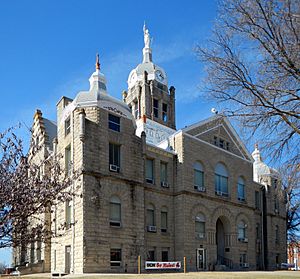
Johnson County Courthouse in Warrensburg
|
|

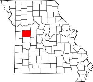
Location within the U.S. state of Missouri
|
|
 Missouri's location within the U.S. |
|
| Country | |
| State | |
| Founded | December 13, 1833 |
| Named for | Richard Mentor Johnson |
| Seat | Warrensburg |
| Largest city | Warrensburg |
| Area | |
| • Total | 833 sq mi (2,160 km2) |
| • Land | 829 sq mi (2,150 km2) |
| • Water | 3.9 sq mi (10 km2) 0.5% |
| Population
(2020)
|
|
| • Total | 54,013 |
| • Density | 65/sq mi (25/km2) |
| Time zone | UTC−6 (Central) |
| • Summer (DST) | UTC−5 (CDT) |
| Congressional district | 4th |
Johnson County is a county located in the western part of Missouri, a state in the United States. A county is like a smaller area within a state, often with its own local government.
In 2020, about 54,013 people lived in Johnson County. The main town, or county seat, is Warrensburg. The county was officially created on December 13, 1834. It was named after Richard Mentor Johnson, who was a Vice President of the United States.
Johnson County is part of a larger area around Warrensburg. It is also connected to the bigger Kansas City region, which includes cities in both Missouri and Kansas.
Contents
Geography of Johnson County
Johnson County covers a total area of about 833 square miles. Most of this area, about 829 square miles, is land. The rest, about 3.9 square miles, is water.
Neighboring Counties
Johnson County shares its borders with several other counties:
- Lafayette County to the north
- Pettis County to the east
- Henry County to the south
- Cass County to the west
- Jackson County to the northwest
Main Roads and Highways
Several important roads run through Johnson County, making it easy to travel around:
Population and People
The number of people living in Johnson County has changed over time. Here's how the population has grown:
| Historical population | |||
|---|---|---|---|
| Census | Pop. | %± | |
| 1840 | 4,471 | — | |
| 1850 | 7,464 | 66.9% | |
| 1860 | 14,614 | 95.8% | |
| 1870 | 24,648 | 68.7% | |
| 1880 | 28,172 | 14.3% | |
| 1890 | 28,132 | −0.1% | |
| 1900 | 27,843 | −1.0% | |
| 1910 | 26,297 | −5.6% | |
| 1920 | 24,899 | −5.3% | |
| 1930 | 22,413 | −10.0% | |
| 1940 | 21,617 | −3.6% | |
| 1950 | 20,716 | −4.2% | |
| 1960 | 28,981 | 39.9% | |
| 1970 | 34,172 | 17.9% | |
| 1980 | 39,059 | 14.3% | |
| 1990 | 42,514 | 8.8% | |
| 2000 | 48,258 | 13.5% | |
| 2010 | 52,595 | 9.0% | |
| 2020 | 54,013 | 2.7% | |
| U.S. Decennial Census 1790-1960 1900-1990 1990-2000 2010 |
|||
In 2000, there were about 48,258 people living in the county. There were also 17,410 households, which are groups of people living together. About 11,821 of these were families.
The population was spread out in terms of age. About 25% of the people were under 18 years old. About 20% were between 18 and 24, and 27% were between 25 and 44. The median age was 28 years old.
2020 Census Information
The 2020 census showed the following breakdown of people in Johnson County:
| Race | Number | Percentage |
|---|---|---|
| White (not Hispanic) | 44,415 | 82.23% |
| Black or African American (not Hispanic) | 2,309 | 4.27% |
| Native American (not Hispanic) | 259 | 0.48% |
| Asian (not Hispanic) | 821 | 1.52% |
| Pacific Islander (not Hispanic) | 210 | 0.39% |
| Other/Mixed (not Hispanic) | 3,404 | 6.3% |
| Hispanic or Latino | 2,595 | 4.8% |
Education in Johnson County
Johnson County has many schools and learning centers for students of all ages.
Public Schools
There are several public school districts in the county, each serving different towns:
- Chilhowee R-IV School District in Chilhowee
- Chilhowee Elementary School (Grades P–6)
- Chilhowee High School (Grades 7–12)
- Holden R-III School District in Holden
- Holden Elementary School (Grades P–5)
- Holden Intermediate School (Grades 3–5)
- Holden Middle School (Grades 6–8)
- Holden High School (Grades 9–12)
- Johnson County R-VII School District in Centerview
- Crest Ridge Elementary School (Grades P–5)
- Crest Ridge Middle School (Grades 6–8)
- Crest Ridge High School (Grades 9–12)
- Kingsville R-I School District in Kingsville
- Kingsville Elementary School (Grades K–6)
- Kingsville High School (Grades 7–12)
- Knob Noster R-VIII School District in Knob Noster
- Knob Noster Elementary School (Grades P–5)
- Whiteman Air Force Base Elementary School (Grades P–5) – located at Whiteman
- Knob Noster Middle School (Grades 6–8)
- Knob Noster High School (Grades 9–12)
- Leeton R-X School District in Leeton
- Leeton Elementary School (Grades P–5)
- Leeton Middle School (Grades 6–8)
- Leeton High School (Grades 9–12)
- Warrensburg R-VI School District in Warrensburg
- Reese Early Childhood Education Center
- Maple Grove Elementary School (Grades P–2)
- Ridge View Elementary School (Grades P–2)
- Martin Warren Elementary School (Grades 3–5)
- Sterling Elementary School (Grades 3–5)
- Warrensburg Middle School (Grades 6–8)
- Warrensburg High School (Grades 9–12)
- Warrensburg Area Career Center
Private Schools
- Johnson County Christian Academy in Centerview (Grades K–9) – a Nondenominational Christian school.
Colleges and Universities
- University of Central Missouri in Warrensburg – This is a public university where students can earn four-year degrees.
Public Libraries
- Holden Public Library
- Trails Regional Library
Communities in Johnson County
Johnson County is made up of several cities, villages, and other smaller communities.
Cities
- Holden
- Knob Noster
- Warrensburg (This is the county seat, where the main county government offices are located.)
Villages
Census-Designated Places
These are areas that are like towns but are not officially incorporated as cities or villages:
- La Tour
- Whiteman AFB
Other Unincorporated Places
These are smaller communities that are not officially part of a city or village:
See also
 In Spanish: Condado de Johnson (Misuri) para niños
 | Aaron Henry |
 | T. R. M. Howard |
 | Jesse Jackson |

