Knob Noster, Missouri facts for kids
Quick facts for kids
Knob Noster, Missouri
|
|
|---|---|
| City of Knob Noster | |

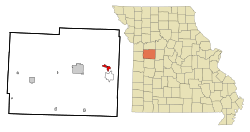
Location of Knob Noster, Missouri
|
|
| Country | United States |
| State | Missouri |
| County | Johnson |
| Area | |
| • Total | 2.91 sq mi (7.53 km2) |
| • Land | 2.88 sq mi (7.46 km2) |
| • Water | 0.03 sq mi (0.06 km2) |
| Elevation | 801 ft (244 m) |
| Population
(2020)
|
|
| • Total | 2,782 |
| • Density | 965.64/sq mi (372.81/km2) |
| Time zone | UTC-6 (Central (CST)) |
| • Summer (DST) | UTC-5 (CDT) |
| ZIP codes |
65336
|
| Area code(s) | 660 |
| FIPS code | 29-39188 |
| GNIS feature ID | 0729757 |
Knob Noster is a city located in Johnson County, Missouri, in the United States. In 2020, about 2,782 people lived there. The city is very close to Whiteman Air Force Base, which is an important military base. Also, Knob Noster State Park is nearby, offering outdoor activities.
Contents
History of Knob Noster
Knob Noster was officially planned out in 1856. It was set up by William A. Wortham. The community became an official town on December 14, 1859.
The name "Knob Noster" comes from the unique hills, or "knobs," that stand out on the flat land near the town. The second part of the name, "Noster," might have been suggested by a school teacher. Some people think it comes from a Latin phrase meaning "Our Knobs." The town moved to its current spot when the Pacific Railroad was built. Knob Noster has had a post office since 1846.
Geography and Location
Knob Noster is found along U.S. Route 50. It is about nine miles east of Warrensburg. To the southwest, you'll find Knob Noster State Park along Missouri Route 23. Whiteman Air Force Base is located directly south of the city, about one mile away.
The United States Census Bureau says that Knob Noster covers a total area of about 2.91 square miles (7.53 square kilometers). Most of this area, about 2.88 square miles (7.46 square kilometers), is land. A small part, about 0.03 square miles (0.06 square kilometers), is water.
Population Information
| Historical population | |||
|---|---|---|---|
| Census | Pop. | %± | |
| 1870 | 914 | — | |
| 1880 | 689 | −24.6% | |
| 1890 | 851 | 23.5% | |
| 1900 | 673 | −20.9% | |
| 1910 | 670 | −0.4% | |
| 1920 | 617 | −7.9% | |
| 1930 | 683 | 10.7% | |
| 1940 | 640 | −6.3% | |
| 1950 | 585 | −8.6% | |
| 1960 | 2,292 | 291.8% | |
| 1970 | 2,264 | −1.2% | |
| 1980 | 2,040 | −9.9% | |
| 1990 | 2,261 | 10.8% | |
| 2000 | 2,462 | 8.9% | |
| 2010 | 2,709 | 10.0% | |
| 2020 | 2,782 | 2.7% | |
| U.S. Decennial Census | |||
Population in 2010
In 2010, there were 2,709 people living in Knob Noster. The city had 1,147 households. The population density was about 940.6 people per square mile.
The average age of people in the city was 27.1 years old. About 25.4% of the residents were under 18 years old. About 18.4% were between 18 and 24 years old. People aged 65 or older made up about 7.9% of the population. There were slightly more males (51.6%) than females (48.4%) living in the city.
Education in Knob Noster
The Knob Noster R-VIII School District is in charge of the schools in the area. This district runs two elementary schools and one middle school. Students attend Knob Noster High School for their high school education. Knob Noster also has a public library, which is part of the Trails Regional Library system.
See also
 In Spanish: Knob Noster (Misuri) para niños
 | Georgia Louise Harris Brown |
 | Julian Abele |
 | Norma Merrick Sklarek |
 | William Sidney Pittman |

