Otterville, Missouri facts for kids
Quick facts for kids
Otterville, Missouri
|
|
|---|---|
|
City
|
|

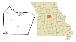
Location of Otterville, Missouri
|
|
| Country | United States |
| State | Missouri |
| County | Cooper |
| Township | Otterville |
| Founded | 1837 (as Elkton) 1848 (as Otterville) |
| Incorporated | 1848 |
| Named for | Otter Creek |
| Area | |
| • Total | 0.49 sq mi (1.27 km2) |
| • Land | 0.49 sq mi (1.27 km2) |
| • Water | 0.00 sq mi (0.00 km2) |
| Elevation | 810 ft (250 m) |
| Population
(2020)
|
|
| • Total | 440 |
| • Density | 899.80/sq mi (347.23/km2) |
| Time zone | UTC-6 (Central (CST)) |
| • Summer (DST) | UTC-5 (CDT) |
| ZIP code |
65348
|
| Area code(s) | 660 |
| FIPS code | 29-55478 |
| GNIS feature ID = | 2396108 |
Otterville is a small city located in the southwestern part of Cooper County, Missouri, in the United States. In 2010, about 454 people lived there. By 2020, the population was 440.
Contents
History of Otterville
Otterville has an interesting past! It was first known as Elkton. The town was officially planned out in 1837 under this first name.
Later, the name changed to Otterville. This new name came from a nearby stream called Otter Creek. A post office opened in Otterville in 1848. It has been helping people send mail ever since.
Geography of Otterville
Otterville is found along routes A and BB. These routes are just north of the county line and U.S. Route 50. The city is also near the Long Branch, which is a small stream flowing into the Lamine River.
The Lamine River Conservation Area is located about one mile east of Otterville. Other nearby towns include Clifton City to the north and Syracuse to the east-southeast. Smithton is southwest, and Sedalia is about twelve miles to the west.
Land Area
According to the United States Census Bureau, Otterville covers a total area of about 0.49 square miles (1.27 square kilometers). All of this area is land, with no significant water bodies within the city limits.
Population and People
| Historical population | |||
|---|---|---|---|
| Census | Pop. | %± | |
| 1880 | 505 | — | |
| 1890 | 439 | −13.1% | |
| 1900 | 384 | −12.5% | |
| 1910 | 453 | 18.0% | |
| 1920 | 482 | 6.4% | |
| 1930 | 421 | −12.7% | |
| 1940 | 430 | 2.1% | |
| 1950 | 414 | −3.7% | |
| 1960 | 416 | 0.5% | |
| 1970 | 440 | 5.8% | |
| 1980 | 472 | 7.3% | |
| 1990 | 507 | 7.4% | |
| 2000 | 476 | −6.1% | |
| 2010 | 454 | −4.6% | |
| 2020 | 440 | −3.1% | |
| U.S. Decennial Census | |||
Otterville in 2010
In 2010, there were 454 people living in Otterville. These people made up 190 households. About 125 of these households were families.
The city had a population density of about 926 people per square mile. Most of the people living in Otterville were White (96.3%). A smaller number were African American (1.3%) or Native American (0.7%). Some people (1.8%) were from two or more racial backgrounds. About 1.1% of the population identified as Hispanic or Latino.
Households and Age
Out of the 190 households, about 33.7% had children under 18 years old living with them. Many households (48.9%) were married couples living together.
The average household had about 2.39 people. The average family had about 2.90 people.
The average age of people in Otterville was 36 years old. About 26.9% of residents were under 18. About 15.9% were 65 years old or older. The city had slightly more females (52.9%) than males (47.1%).
Media and Radio
Otterville is home to a radio station called KCVK (107.7 FM). This station is part of Spirit FM. Spirit FM is a network of Christian music and talk radio stations. These stations are owned by the Lake Area Educational Broadcasting Foundation. KCVK's programs actually come from KCVO, another station located in Camdenton.
See also
 In Spanish: Otterville (Misuri) para niños
 | Precious Adams |
 | Lauren Anderson |
 | Janet Collins |


