Syracuse, Missouri facts for kids
Quick facts for kids
Syracuse, Missouri
|
|
|---|---|

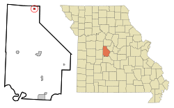
Location in Morgan County and the state of Missouri
|
|
| Country | United States |
| State | Missouri |
| County | Morgan |
| Area | |
| • Total | 0.38 sq mi (0.97 km2) |
| • Land | 0.38 sq mi (0.97 km2) |
| • Water | 0.00 sq mi (0.00 km2) |
| Elevation | 909 ft (277 m) |
| Population
(2020)
|
|
| • Total | 151 |
| • Density | 402.67/sq mi (155.46/km2) |
| Time zone | UTC-6 (Central (CST)) |
| • Summer (DST) | UTC-5 (CDT) |
| ZIP code |
65354
|
| Area code(s) | 660 |
| FIPS code | 29-72106 |
| GNIS feature ID | 2396022 |
Syracuse is a small city in Morgan County, Missouri, in the United States. In 2020, 151 people lived there.
In the mid-1800s, Syracuse was an important stop. It was the end of the Pacific Railway line, which stretched 108 miles from St. Louis. The current mayor of Syracuse is Duane A. Doyle.
Contents
History of Syracuse
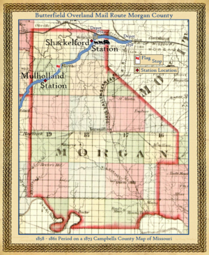
In 1859, the railroad reached Syracuse. This made it the final stop for the Butterfield Overland Mail Route. This route was a famous way to deliver mail and people across the country.
In 2023, the Butterfield Overland Mail Route was named a national historic trail. This means it's a special place that helps tell the story of American history. Syracuse was first called "Pacific City." It was planned out in 1858. The city later changed its name to Syracuse, like the city in Syracuse, New York.
Geography of Syracuse
Syracuse is located in the northern part of Morgan County. It sits along U.S. Route 50. This road goes east 5 miles to Tipton. It goes west 19 miles to Sedalia.
Versailles is the main town of Morgan County. It is 19 miles south of Syracuse. You can get there using smaller roads.
Land and Water
Syracuse covers about 0.38 square miles (0.97 square kilometers) of land. There is no water area within the city limits. The city is on a high area of land. Water from this area flows in two directions. Some water goes southeast into Messer Creek. Other water goes northwest into Otter Creek. Both of these creeks flow into the Lamine River. The Lamine River then flows north into the large Missouri River.
Population Changes
Syracuse has seen its population change over the years. Here's how many people lived there during different census counts:
| Historical population | |||
|---|---|---|---|
| Census | Pop. | %± | |
| 1880 | 202 | — | |
| 1890 | 187 | −7.4% | |
| 1900 | 175 | −6.4% | |
| 1910 | 193 | 10.3% | |
| 1920 | 288 | 49.2% | |
| 1930 | 288 | 0.0% | |
| 1940 | 262 | −9.0% | |
| 1950 | 221 | −15.6% | |
| 1960 | 180 | −18.6% | |
| 1970 | 214 | 18.9% | |
| 1980 | 222 | 3.7% | |
| 1990 | 185 | −16.7% | |
| 2000 | 172 | −7.0% | |
| 2010 | 172 | 0.0% | |
| 2020 | 151 | −12.2% | |
| U.S. Decennial Census | |||
Syracuse in 2010
In 2010, there were 172 people living in Syracuse. These people lived in 68 different homes. About 45 of these homes were families. The city had about 453 people per square mile.
Most people in Syracuse were White (98.8%). A small number (1.2%) were from two or more races. About 3.5% of the people were Hispanic or Latino.
About 29% of homes had children under 18. Many homes (45.6%) were married couples. Some homes had a single parent. About 22% of homes had only one person living there.
The average age in Syracuse was 37.7 years old. About 25% of residents were under 18. About 15.7% were 65 or older. The city had slightly more females (51.7%) than males (48.3%).
KMOS-TV Tower
Syracuse is home to the KMOS TV Tower. This tall structure was built in 2003. It is operated by the University of Central Missouri. The tower is 2,000 feet (610 meters) tall. This makes it the tallest structure in the entire state of Missouri!
See also
 In Spanish: Syracuse (Misuri) para niños
 | Sharif Bey |
 | Hale Woodruff |
 | Richmond Barthé |
 | Purvis Young |


