Blackburn, Missouri facts for kids
Quick facts for kids
Blackburn, Missouri
|
|
|---|---|

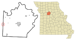
Location of Blackburn, Missouri
|
|
| Country | United States |
| State | Missouri |
| Counties | Saline, Lafayette |
| Area | |
| • Total | 0.32 sq mi (0.83 km2) |
| • Land | 0.31 sq mi (0.80 km2) |
| • Water | 0.01 sq mi (0.03 km2) |
| Elevation | 787 ft (240 m) |
| Population
(2020)
|
|
| • Total | 224 |
| • Density | 724.92/sq mi (279.99/km2) |
| Time zone | UTC-6 (Central (CST)) |
| • Summer (DST) | UTC-5 (CDT) |
| ZIP code |
65321
|
| Area code(s) | 660 |
| FIPS code | 29-05950 |
| GNIS feature ID | 2394180 |
Blackburn is a small city located in the state of Missouri, United States. It is found in both Lafayette and Saline counties. Blackburn is also considered part of the larger Kansas City metropolitan area. In 2020, about 224 people lived in Blackburn.
Contents
History of Blackburn
Blackburn was officially planned and laid out in 1880. This happened when a railroad line was built through the area. Before that, a post office had already been operating in Blackburn since 1878. The town gets its name from an English town called Lancashire, and also from Francis Blackburn, who was one of the first people to settle there.
Geography of Blackburn
Blackburn is a small city in terms of its size. According to the United States Census Bureau, the city covers a total area of about 0.32 square miles (0.83 square kilometers). Most of this area, about 0.31 square miles (0.80 square kilometers), is land. A very small part, about 0.01 square miles (0.03 square kilometers), is water.
Population and People
| Historical population | |||
|---|---|---|---|
| Census | Pop. | %± | |
| 1880 | 214 | — | |
| 1890 | 372 | 73.8% | |
| 1900 | 458 | 23.1% | |
| 1910 | 389 | −15.1% | |
| 1920 | 333 | −14.4% | |
| 1930 | 292 | −12.3% | |
| 1940 | 314 | 7.5% | |
| 1950 | 306 | −2.5% | |
| 1960 | 310 | 1.3% | |
| 1970 | 294 | −5.2% | |
| 1980 | 314 | 6.8% | |
| 1990 | 308 | −1.9% | |
| 2000 | 284 | −7.8% | |
| 2010 | 249 | −12.3% | |
| 2020 | 224 | −10.0% | |
| U.S. Decennial Census | |||
Blackburn's Population in 2010
The census taken in 2010 showed that 249 people lived in Blackburn. These people lived in 107 different homes. Out of these homes, 72 were families.
The city had about 803 people per square mile (310 people per square kilometer). There were 124 housing units, which are places where people can live.
Most of the people in Blackburn were White, making up 92.0% of the population. About 3.2% were African American, and 1.2% were from other racial backgrounds. About 3.6% of the people identified with two or more races. People of Hispanic or Latino background made up 2.8% of the population.
In 2010, about 29.9% of homes had children under 18 living there. Many homes, 57.0%, were married couples living together. The average number of people in each home was 2.33. For families, the average size was 2.82 people.
The average age of people in Blackburn was 44.8 years old. About 22.9% of residents were under 18. People aged 65 or older made up 19.7% of the population. The city had slightly more females (51.8%) than males (48.2%).
See also
 In Spanish: Blackburn (Misuri) para niños
 | Jessica Watkins |
 | Robert Henry Lawrence Jr. |
 | Mae Jemison |
 | Sian Proctor |
 | Guion Bluford |

