Emma, Missouri facts for kids
Quick facts for kids
Emma, Missouri
|
|
|---|---|

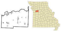
Location of Emma, Missouri
|
|
| Country | United States |
| State | Missouri |
| Counties | Saline, Lafayette |
| Area | |
| • Total | 0.59 sq mi (1.52 km2) |
| • Land | 0.59 sq mi (1.52 km2) |
| • Water | 0.00 sq mi (0.00 km2) |
| Elevation | 745 ft (227 m) |
| Population
(2020)
|
|
| • Total | 201 |
| • Density | 343.00/sq mi (132.42/km2) |
| Time zone | UTC-6 (Central (CST)) |
| • Summer (DST) | UTC-5 (CDT) |
| ZIP code |
65327
|
| Area code(s) | 660 |
| FIPS code | 29-22312 |
| GNIS feature ID | 2394688 |
Emma is a small city in the state of Missouri, United States. It is located in both Lafayette and Saline counties. Emma is also part of the larger Kansas City metropolitan area. In 2020, the city had a population of 201 people.
Contents
History of Emma
The city of Emma was named after Emma Demetrio. She was the daughter of a local minister.
During the American Civil War (1861-1865), the area around Emma saw a lot of conflict. Many German settlers in Missouri were against slavery. They had come to America seeking freedom and better opportunities.
In 1861, some German men from the Lafayette-Saline area joined the Union's Home Guards. These were local groups who helped protect their communities. While they were away, Southern groups raided their homes, taking horses and other goods.
Later, in 1862, more German men joined the militia. Again, Southern groups, called guerrillas or bushwhackers, attacked the community. On October 5, 1862, they took eleven men prisoner from a home gathering. Three of these men were killed.
Another attack happened on July 13, 1863. Four more German militia members were captured and killed. Famous bushwhacker leaders like "Bloody Bill" Anderson were known to be against the German farmers.
In October 1864, a large group of bushwhackers attacked the German settlement near present-day Emma. About 50 German men tried to defend their community. They fought bravely, but 24 of them were killed in a very violent attack. After this, the bushwhackers continued to attack and burn homes in the German community. This was one of their last major attacks.
Geography
Emma is a small city with a total area of about 0.59 square miles (1.52 square kilometers). All of this area is land.
The city is located just south of Interstate 70, a major highway.
Population Information
| Historical population | |||
|---|---|---|---|
| Census | Pop. | %± | |
| 1960 | 202 | — | |
| 1970 | 224 | 10.9% | |
| 1980 | 267 | 19.2% | |
| 1990 | 194 | −27.3% | |
| 2000 | 243 | 25.3% | |
| 2010 | 233 | −4.1% | |
| 2020 | 201 | −13.7% | |
| U.S. Decennial Census | |||
2010 Population Details
In 2010, Emma had 233 residents living in 94 households. About 66 of these were family households. The city had a population density of about 542 people per square mile (210 people per square kilometer).
Most of the people living in Emma were White (98.3%). About 1.7% of the population identified as Hispanic or Latino.
In terms of households, 26.6% had children under 18 living with them. Most households (61.7%) were married couples living together. The average household had 2.48 people, and the average family had 3.00 people.
The average age of residents in Emma was 42.4 years. About 22.3% of the residents were under 18 years old. About 21.5% were 65 years or older. The population was almost evenly split between males (51.9%) and females (48.1%).
Fun Things to Do
Emma Indoor Raceway
The Emma Indoor Raceway is a cool place for racing fans. It's located north of Interstate 70. During the winter months, from October to February, you can watch or even race Quad Bikes and karts on a dirt track. Races usually happen on Saturday evenings.
Tri-City Country Club
If you enjoy golf or swimming, the Tri-City Country Club is a great spot. It's located west of the Emma Post Office. The club has a 9-hole golf course and a swimming pool. There's also a kitchen in the main building that serves tasty grilled and fried foods.
See also
 In Spanish: Emma (Misuri) para niños
 | Shirley Ann Jackson |
 | Garett Morgan |
 | J. Ernest Wilkins Jr. |
 | Elijah McCoy |

