Henrietta, Missouri facts for kids
Quick facts for kids
Henrietta, Missouri
|
|
|---|---|

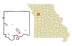
Location of Henrietta, Missouri
|
|
| Country | United States |
| State | Missouri |
| County | Ray |
| Area | |
| • Total | 0.60 sq mi (1.54 km2) |
| • Land | 0.60 sq mi (1.54 km2) |
| • Water | 0.00 sq mi (0.00 km2) |
| Elevation | 705 ft (215 m) |
| Population
(2020)
|
|
| • Total | 278 |
| • Density | 466.44/sq mi (179.97/km2) |
| Time zone | UTC-6 (Central (CST)) |
| • Summer (DST) | UTC-5 (CDT) |
| ZIP code |
64036
|
| Area code(s) | 816 |
| FIPS code | 29-31654 |
| GNIS feature ID | 2394353 |
Henrietta is a small city located in the southern part of Ray County, Missouri. It's also considered part of the larger Kansas City metropolitan area in the United States. In 2020, about 278 people lived there.
Contents
History of Henrietta
Henrietta was officially planned and mapped out in 1868. It was named after Henrietta Watkins, who was the wife of one of the first people to settle there. For a short time, it was also known as "Henry." A post office opened with the name Henry in 1869, but the city's name was changed to Henrietta in 1908.
Where is Henrietta?
Henrietta is located about 27 miles (43 kilometers) east of Independence. It is also about 35 miles (56 kilometers) east of Kansas City. As mentioned, it's part of the bigger Kansas City metropolitan area.
The United States Census Bureau says that Henrietta covers a total area of 0.60 square miles (1.54 square kilometers). All of this area is land, with no water.
People of Henrietta
| Historical population | |||
|---|---|---|---|
| Census | Pop. | %± | |
| 1890 | 315 | — | |
| 1900 | 385 | 22.2% | |
| 1910 | 443 | 15.1% | |
| 1920 | 630 | 42.2% | |
| 1930 | 632 | 0.3% | |
| 1940 | 544 | −13.9% | |
| 1950 | 462 | −15.1% | |
| 1960 | 497 | 7.6% | |
| 1970 | 466 | −6.2% | |
| 1980 | 424 | −9.0% | |
| 1990 | 412 | −2.8% | |
| 2000 | 457 | 10.9% | |
| 2010 | 369 | −19.3% | |
| 2020 | 278 | −24.7% | |
| U.S. Decennial Census | |||
What the 2010 Census Showed
The census taken in 2010 counted 369 people living in Henrietta. These people lived in 109 different homes, and 75 of those were families. The city had about 615 people per square mile (237 people per square kilometer). There were 141 housing units in total.
Most of the people in Henrietta were White (93.5%). A smaller number were African American (5.4%), Native American (0.5%), or from other backgrounds. About 4.6% of the population identified as Hispanic or Latino.
Out of the 109 homes:
- 34.9% had children under 18 living there.
- 43.1% were married couples living together.
- 17.4% had a female head of the house with no husband present.
- 8.3% had a male head of the house with no wife present.
- 31.2% were not families (meaning people living alone or with roommates).
On average, each home had 2.64 people, and each family had 3.03 people.
The average age of people in Henrietta was 37.1 years old.
- 21.4% of residents were under 18.
- 11.9% were between 18 and 24.
- 29.5% were between 25 and 44.
- 27.1% were between 45 and 64.
- 10% were 65 years old or older.
More males lived in Henrietta than females, with 55.8% being male and 44.2% being female.
See also
 In Spanish: Henrietta (Misuri) para niños
 | Selma Burke |
 | Pauline Powell Burns |
 | Frederick J. Brown |
 | Robert Blackburn |

