
Independence, Missouri facts for kids
Quick facts for kids
Independence, Missouri
|
|
|---|---|

Jackson County Courthouse in Independence
|
|

Location of Independence in Missouri
|
|
| Country | United States |
| State | Missouri |
| County | Jackson |
| Founded | March 29, 1827 |
| Named for | The Declaration of Independence |
| Area | |
| • Total | 78.42 sq mi (203.10 km2) |
| • Land | 77.97 sq mi (201.93 km2) |
| • Water | 0.45 sq mi (1.17 km2) |
| Elevation | 863 ft (263 m) |
| Population
(2020)
|
|
| • Total | 123,011 |
| • Density | 1,577.75/sq mi (609.17/km2) |
| Demonym(s) | Independencian |
| Time zone | UTC−6 (Central (CST)) |
| • Summer (DST) | UTC−5 (CDT) |
| ZIP Codes |
64050–64057
|
| Area code(s) | 816 |
| FIPS code | 29-35000 |
| GNIS feature ID | 2395422 |
Independence is a city in Missouri, United States. It is the main city of Jackson County, Missouri. Independence is very close to Kansas City, Missouri. It is the biggest suburb on the Missouri side of the Kansas City metropolitan area. In 2020, about 123,011 people lived there. This makes it the fifth-largest city in Missouri.
Independence is often called the "Queen City of the Trails." This is because it was a major starting point for pioneers. They began their journeys on the California Trail, Oregon Trail, and Santa Fe Trail here. The city is also famous as the hometown of U.S. President Harry S. Truman. You can visit the Harry S. Truman Presidential Library and Museum and see where he and his wife, Bess Truman, are buried. Independence is also important to the Latter Day Saint movement. It is home to a special place called the Temple Lot and is the main office for several Mormon groups.
Contents
History of Independence
Long ago, Native American tribes like the Missouri and Osage lived here. Then, Spanish and French people briefly settled the area. In 1803, Independence became part of the United States through the Louisiana Purchase. Explorers Lewis and Clark even stopped here in 1804. They wrote in their journals about picking fruits like plums and raspberries.
The city was named after the United States Declaration of Independence. It was founded on March 29, 1827. Independence quickly became a very important frontier town. It was the farthest west that large boats could travel on the Missouri River. This made it a perfect place for traders and adventurers. They would start their long trips west on the Santa Fe Trail from here.

In 1831, members of the Latter Day Saint movement started moving to the area. Their founder, Joseph Smith, said a special temple would be built here. This led to some disagreements with local Missourians. The Latter Day Saints eventually left the area in 1833. However, many groups from this movement later returned. Today, several of their main offices are in Independence. These include the Community of Christ and the Church of Christ (Temple Lot).
Independence grew a lot from the late 1830s to the mid-1840s. This was because many pioneers started their westward journeys here. From 1848 to 1868, it was a major center for the California Trail. In 1849, Independence became an official town. William McCoy was elected as its first mayor. The U.S. Congress even said Independence was the official start of the Oregon Trail.


Independence saw two important battles during the American Civil War. In 1862, Confederate soldiers took control of the town. In 1864, Union soldiers won a battle here. The war caused a lot of damage to the city. It never became as rich as it was before. Also, nearby Kansas City, Missouri grew much larger. Still, Independence has remained the county seat of Jackson County.
United States President Harry S. Truman grew up in Independence. In 1922, he was elected a judge for Jackson County. He worked hard and was known for building new roads and a new courthouse. He also helped create monuments to pioneer women. After being president for two terms, he returned to Independence. His wife, Bess Truman, was also from Independence. Both are buried in the city. You can visit the Harry S. Truman National Historic Site (his home) and the Harry S. Truman Presidential Library and Museum in Independence.
Geography and Climate
Independence is located on the south side of the Missouri River. It is near the western edge of Missouri. The city covers about 78 square miles. Most of this area is land, with a small part being water.
| Climate data for Independence, Missouri (1991–2020 normals, extremes 1973–2021) | |||||||||||||
|---|---|---|---|---|---|---|---|---|---|---|---|---|---|
| Month | Jan | Feb | Mar | Apr | May | Jun | Jul | Aug | Sep | Oct | Nov | Dec | Year |
| Record high °F (°C) | 74 (23) |
79 (26) |
87 (31) |
94 (34) |
93 (34) |
103 (39) |
104 (40) |
109 (43) |
103 (39) |
94 (34) |
82 (28) |
72 (22) |
109 (43) |
| Mean maximum °F (°C) | 62.2 (16.8) |
67.9 (19.9) |
77.6 (25.3) |
83.0 (28.3) |
87.8 (31.0) |
93.4 (34.1) |
96.9 (36.1) |
97.4 (36.3) |
92.3 (33.5) |
84.9 (29.4) |
72.6 (22.6) |
64.8 (18.2) |
99.3 (37.4) |
| Mean daily maximum °F (°C) | 37.6 (3.1) |
43.0 (6.1) |
54.5 (12.5) |
64.6 (18.1) |
73.9 (23.3) |
82.9 (28.3) |
86.9 (30.5) |
86.0 (30.0) |
78.4 (25.8) |
66.5 (19.2) |
53.0 (11.7) |
41.8 (5.4) |
64.1 (17.8) |
| Daily mean °F (°C) | 28.4 (−2.0) |
33.1 (0.6) |
43.5 (6.4) |
53.6 (12.0) |
63.8 (17.7) |
73.2 (22.9) |
77.4 (25.2) |
75.8 (24.3) |
67.7 (19.8) |
55.8 (13.2) |
43.3 (6.3) |
32.9 (0.5) |
54.0 (12.2) |
| Mean daily minimum °F (°C) | 19.2 (−7.1) |
23.1 (−4.9) |
32.6 (0.3) |
42.6 (5.9) |
53.7 (12.1) |
63.5 (17.5) |
67.8 (19.9) |
65.7 (18.7) |
57.0 (13.9) |
45.1 (7.3) |
33.5 (0.8) |
23.9 (−4.5) |
44.0 (6.7) |
| Mean minimum °F (°C) | −0.1 (−17.8) |
6.3 (−14.3) |
15.1 (−9.4) |
28.1 (−2.2) |
40.7 (4.8) |
51.7 (10.9) |
58.7 (14.8) |
56.7 (13.7) |
43.3 (6.3) |
29.7 (−1.3) |
17.7 (−7.9) |
6.2 (−14.3) |
−3.3 (−19.6) |
| Record low °F (°C) | −16 (−27) |
−13 (−25) |
−5 (−21) |
14 (−10) |
30 (−1) |
43 (6) |
50 (10) |
43 (6) |
33 (1) |
20 (−7) |
1 (−17) |
−14 (−26) |
−16 (−27) |
| Average precipitation inches (mm) | 1.50 (38) |
1.86 (47) |
2.88 (73) |
4.43 (113) |
5.99 (152) |
5.28 (134) |
5.11 (130) |
5.06 (129) |
4.77 (121) |
3.54 (90) |
2.40 (61) |
1.84 (47) |
44.66 (1,134) |
| Average snowfall inches (cm) | 3.6 (9.1) |
2.6 (6.6) |
1.7 (4.3) |
0.2 (0.51) |
0.0 (0.0) |
0.0 (0.0) |
0.0 (0.0) |
0.0 (0.0) |
0.0 (0.0) |
0.4 (1.0) |
1.2 (3.0) |
3.5 (8.9) |
13.2 (34) |
| Average precipitation days (≥ 0.01 in) | 6.8 | 6.2 | 9.6 | 10.9 | 13.3 | 9.9 | 10.0 | 9.2 | 8.6 | 8.7 | 6.8 | 6.9 | 106.9 |
| Average snowy days (≥ 0.1 in) | 3.0 | 2.1 | 1.1 | 0.2 | 0.0 | 0.0 | 0.0 | 0.0 | 0.0 | 0.0 | 0.2 | 2.8 | 10.0 |
| Source: NOAA | |||||||||||||
People of Independence
| Historical population | |||
|---|---|---|---|
| Census | Pop. | %± | |
| 1860 | 3,164 | — | |
| 1870 | 3,184 | 0.6% | |
| 1880 | 3,146 | −1.2% | |
| 1890 | 6,380 | 102.8% | |
| 1900 | 6,974 | 9.3% | |
| 1910 | 9,859 | 41.4% | |
| 1920 | 11,686 | 18.5% | |
| 1930 | 15,296 | 30.9% | |
| 1940 | 16,066 | 5.0% | |
| 1950 | 36,963 | 130.1% | |
| 1960 | 62,328 | 68.6% | |
| 1970 | 111,630 | 79.1% | |
| 1980 | 111,806 | 0.2% | |
| 1990 | 112,295 | 0.4% | |
| 2000 | 113,288 | 0.9% | |
| 2010 | 116,830 | 3.1% | |
| 2020 | 123,011 | 5.3% | |
| U.S. Decennial Census 2018 Estimate |
|||
In 2020, Independence had 123,011 people. There were about 48,836 households. Most people in Independence are white. However, there are also many African American, Native American, Asian, and Pacific Islander residents. About 12% of the population is Hispanic or Latino.
The average age in the city is about 39.5 years old. Around 21.5% of the people are under 18. The city has a mix of families and single people living alone.
Religion in Independence
Independence is very important to the early history of the Latter Day Saint movement. It is home to the main offices of several groups from this movement. The Community of Christ has a beautiful temple here. They also have a large auditorium. The Church of Jesus Christ of Latter-day Saints has a visitor center nearby. The original Temple Lot is also in Independence.
The city also has five Catholic churches and several Episcopal churches. The First Presbyterian Church, founded in 1826, is one of the oldest. It's where Harry Truman first met his future wife, Bess Wallace.
Economy and Jobs
Independence has many different types of jobs. Here are some of the top employers in the city:
| # | Employer | Employees |
|---|---|---|
| 1 | Independence School District | 2,200 |
| 2 | Northrop Grumman Innovation Systems | 1,722 |
| 3 | Centerpoint Medical Center | 1,400 |
| 4 | City of Independence | 1,097 |
| 5 | Government Employee Health Association | 743 |
| 6 | Rosewood Health Center at the Groves | 444 |
| 7 | Burd & Fletcher | 274 |
| 8 | Jackson County Circuit Court | 274 |
| 9 | Cable Dahmer Automotive | 271 |
| 10 | Unilever | 260 |
Education in Independence
Independence has several school districts within its city limits. These include Independence, Blue Springs, Fort Osage, and Raytown.

High Schools
There are three public high schools in Independence:
- Truman High School
- Van Horn High School
- William Chrisman High School
Two private high schools are also in the city:
- Center Place Restoration School
- Family Christian Academy
Colleges and Universities
- Blue River Community College is part of the Metropolitan Community College system.
- Graceland University has a campus in Independence.
Libraries and Research Centers

Independence has many libraries and research centers:
- Midwest Genealogy Center: This is the largest public library in America for researching family history.
- The Center for the Study of the Korean War: This center at Graceland University has the biggest collection of information about the Korean War in the U.S.
- Merrill J. Mattes Research Library: This library focuses on the history of the trails pioneers used to settle the American West. It's located at the National Frontier Trails Museum.
- Truman Library Research Center: You can find this at the Harry S. Truman Presidential Library and Museum.
- Jackson County Historical Society Archives & Research Library.
- Mid-Continent Public Library has two branches in Independence.
- Kansas City Public Library has the Trails West Branch here.
Media
Independence has its own daily newspaper, The Examiner. You can also read The Kansas City Star. For TV, KSMO-TV 62, a My Network TV channel, has a transmitter in Independence. The city is also home to Space and Time, a magazine about fantasy and science fiction.
Culture and Fun
Independence hosts several fun events each year.
- Santa-Cali-Gon Days is a big festival held every Labor Day. It celebrates the city's history as a starting point for the Santa Fe Trail, California Trail, and Oregon Trail.
- The Vaile Strawberry Festival happens every June at the Vaile Mansion.
- The Independence Heritage Festival celebrates the many different cultures in the city.
The historic town square has many family-owned shops. The old courthouse looks like Philadelphia's Independence Hall. You can even see Harry S. Truman's old courtroom and office inside.
Museums to Explore
Independence has many interesting museums:
- National Frontier Trails Museum: Learn about the history of pioneers and their journeys west. See covered wagons, maps, and read journal entries. There's even a children's activity room!
- Harry S. Truman Presidential Library and Museum: Discover the life of President Harry S. Truman. See a copy of the Oval Office and a colorful mural. Kids can dress up, sort mail, and make campaign buttons.
- Owens-Rogers Museum: This museum is in the home where famous actress Ginger Rogers was born. See her movie items and learn about her life.
- Leila's Hair Museum: This unique museum has over 350 hair "wreaths" and 1,500 pieces of jewelry made from human hair! It's believed to be the only one of its kind.
- Puppetry Arts Institute: See hundreds of puppets from all over the world. You can even choose a puppet head, paint it, and put on your own show!
- Harry S. Truman National Historic Site: Visit President Truman's home, which is kept just as it was when he lived there. See his hat, coat, and cane in the entryway.
- 1859 Jail, Marshal's Home and Museum: Explore the old jail cells and learn how the marshal and his family lived. There's also an old schoolhouse.
- Bingham-Waggoner Estate: This beautiful home was built in 1852. It was once owned by a famous artist, George Caleb Bingham. See how people lived in the 1890s.
- Chicago and Alton Depot: This old wooden train station from 1879 is full of railroad items. The station master and his family used to live upstairs.
- Vaile Mansion: This huge, 31-room mansion was built in 1881. It's a great example of fancy Victorian architecture. It even had flushing toilets and a huge water tank!
- Community of Christ International Headquarters: Visit the Temple and the Auditorium. You can take free tours and listen to organ concerts. The Children's Peace Pavilion is a free, hands-on museum for kids.
- LDS Visitors Center: Learn about the history and beliefs of the Latter-day Saints. See old items and watch videos about their pioneer lives.
Sports and Recreation
Independence offers many sports activities.
- Blue River Community College has men's and women's soccer teams.
- The Cable Dahmer Arena is home to the Kansas City Mavericks, a minor-league hockey team.
- The arena also hosts the Kansas City Comets, a professional indoor soccer team.
- Crysler Stadium is where the collegiate summer baseball Independence Veterans play.
Local groups like Pop Warner Little Scholars and American Legion Baseball offer sports for kids. The YMCA and Parks and Recreation also have many programs for all ages.
Sister City
Since 1978, Independence has been a sister city with Higashimurayama, Tokyo, Japan. There's even a street named Higashimurayama Street in Independence. A Zen garden celebrates this friendship.
City Services
Transportation
- Highways: Major roads like Interstate 70 connect Independence to other big cities. Other important routes include U.S. Route 24 and U.S. Route 40.
- Train: You can catch a train at the Amtrak Station.
- Bus: The Kansas City Area Transportation Authority (KCATA) provides bus services.
Hospital
- Centerpoint Medical Center is the main hospital in the city.
Utilities
Independence Power & Light (IPL) provides electricity to the city. It started in 1901 and has grown a lot. IPL also buys some power from wind farms to use renewable energy.
Notable People from Independence
Many interesting people have connections to Independence:
- Forrest "Phog" Allen: A famous basketball coach for the KU.
- Jim Butcher: A bestselling author.
- Margaret Truman Daniel: A novelist and the daughter of President Harry and Bess Truman.
- Fatal1ty (Jonathan Wendel): A professional e-sports player.
- Paul Henning: He created popular TV shows like The Beverly Hillbillies.
- Arliss Howard: An actor who has been in many films and TV shows.
- Albert Pujols: A famous baseball player for the St. Louis Cardinals.
- Ginger Rogers: An Academy Award-winning actress and dancer.
- Rick Sutcliffe: A former Major League Baseball pitcher.
- Tech N9ne (Aaron Yates): A well-known rapper.
- Bess Truman: The 33rd First Lady of the United States.
- Harry S. Truman: The 33rd President of the United States.
- Cathay Williams: A female soldier who fought in the Civil War.
- Hiram Young: A formerly enslaved man who became a successful wagon-building business owner.
Images for kids
-
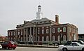
Jackson County Courthouse in Independence
-
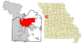
Location of Independence in Missouri
-
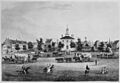
Engraving of the Courthouse in Independence, 1855
-
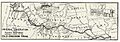
A map of the Oregon Trail, marking Independence.
-
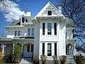
Harry S. Truman's Independence home, now part of the Harry S. Truman National Historic Site.
-
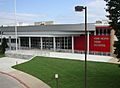
Van Horn High School after the 2011 renovation.
-

Midwest Genealogy Center
-

South Main Street in Independence

See also
 In Spanish: Independence (Misuri) para niños
