Hardin, Missouri facts for kids
Quick facts for kids
Hardin, Missouri
|
|
|---|---|

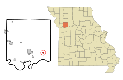
Location of Hardin, Missouri
|
|
| Country | United States |
| State | Missouri |
| County | Ray |
| Area | |
| • Total | 0.64 sq mi (1.67 km2) |
| • Land | 0.64 sq mi (1.67 km2) |
| • Water | 0.00 sq mi (0.00 km2) |
| Elevation | 692 ft (211 m) |
| Population
(2020)
|
|
| • Total | 571 |
| • Density | 888.02/sq mi (342.90/km2) |
| Time zone | UTC-6 (Central (CST)) |
| • Summer (DST) | UTC-5 (CDT) |
| ZIP code |
64035
|
| Area code(s) | 660 |
| FIPS code | 29-30322 |
| GNIS feature ID | 2394294 |
Hardin is a small city located in the southeastern part of Ray County, Missouri, in the United States. It's also considered part of the larger Kansas City metropolitan area. In 2020, about 571 people lived there.
Contents
History of Hardin
The city of Hardin was officially started in 1868. It was named after Charles Henry Hardin, who was the 22nd Governor of Missouri. A post office has been operating in Hardin since 1858, helping people send and receive mail for a very long time.
The Great Flood of 1993 in Hardin
Hardin and its cemetery are located close to the Missouri River. Because of this, they were greatly affected by the Great Flood of 1993. This was a very large flood that impacted many areas.
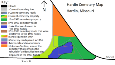
On July 12, 1993, a protective wall, called a levee, that was meant to keep the river out, broke. This caused floodwaters to rush into the city and its cemetery. The floodwaters created a pond right through the cemetery. Sadly, 793 graves were swept away by the powerful water.
Recovering from the Flood
After the flood, a team led by Dean Snow worked hard to recover what was lost. They managed to find 645 sets of remains. However, it was very difficult to figure out who most of them were. Some remains were still inside their vaults or caskets, which made identification a bit easier. Others were scattered and harder to identify.
Since DNA testing was not as advanced back then, people had to be identified using other clues. These included how much the remains had changed over time, whether they were male or female, their estimated age, dental records, and memories from family members.
Out of all the remains found, only 120 were identified. These were then reburied with their original headstones. The remaining 525 sets of remains could not be identified. Some were too changed by time, and for others, there were no records or living relatives to help.
A Special Resting Place
The unidentified remains were reburied together in a large, shared grave. This was done on a new piece of land, about 9.5 acres, that the cemetery bought after the flood. Each unidentified grave was marked with a headstone that said "unknown" and a number. This way, if new technology like advanced DNA testing becomes available in the future, authorities could try to identify them.
In 1994, a special memorial was placed at the western entrance of the cemetery. It honors the 1993 flood and remembers those who could not be identified. Part of the new land also holds the headstones of those whose bodies were not identified. These headstones act as a Cenotaph, which is like a memorial for people whose remains are elsewhere. This allows families to still visit and pay their respects. The rest of the new land was used to rebury the 120 identified bodies and for new burials.
In 1995, a second memorial was added near the shared grave. This memorial lists the names, birth years, and death years of the people whose remains were displaced and could not be identified. Today, the cemetery is 18.5 acres large, and it includes the pond created by the flood.
Geography of Hardin
Hardin is located in a specific area. According to the United States Census Bureau, the city covers a total area of about 0.64 square miles (1.67 square kilometers). All of this area is land, meaning there are no large bodies of water like lakes or rivers within the city limits.
Population and People
The population of Hardin has changed over many years. Here's a look at how many people have lived in the city at different times:
| Historical population | |||
|---|---|---|---|
| Census | Pop. | %± | |
| 1880 | 247 | — | |
| 1890 | 656 | 165.6% | |
| 1900 | 669 | 2.0% | |
| 1910 | 635 | −5.1% | |
| 1920 | 847 | 33.4% | |
| 1930 | 821 | −3.1% | |
| 1940 | 805 | −1.9% | |
| 1950 | 747 | −7.2% | |
| 1960 | 727 | −2.7% | |
| 1970 | 683 | −6.1% | |
| 1980 | 688 | 0.7% | |
| 1990 | 598 | −13.1% | |
| 2000 | 614 | 2.7% | |
| 2010 | 569 | −7.3% | |
| 2020 | 571 | 0.4% | |
| U.S. Decennial Census | |||
Hardin's Population in 2010
Based on the census from 2010, there were 569 people living in Hardin. These people made up 214 households, and 159 of these were families. The city had about 889 people per square mile (342.9 people per square kilometer). There were also 266 housing units, which are places where people live.
Most of the people in Hardin in 2010 were White (98.1%). A smaller number were Native American (1.1%) or Asian (0.2%). About 0.7% of the population identified as being from two or more races. People who identified as Hispanic or Latino made up 1.6% of the population.
Households and Families
In 2010, about 38.8% of the households in Hardin had children under 18 living with them. More than half, 54.7%, were married couples living together. Some households had a female head of the house without a husband (13.6%), or a male head of the house without a wife (6.1%). About 25.7% of households were not families.
About 21.5% of all households were made up of just one person. And 8.8% of households had someone living alone who was 65 years old or older. On average, there were 2.66 people in each household and 3.04 people in each family.
Age Groups in Hardin
The average age of people in Hardin in 2010 was 35.8 years old.
- About 28.3% of residents were under 18 years old.
- 8.5% were between 18 and 24 years old.
- 25.5% were between 25 and 44 years old.
- 27.3% were between 45 and 64 years old.
- 10.4% were 65 years old or older.
The city's population was almost evenly split between genders, with 49.0% male and 51.0% female.
Education in Hardin
Hardin has its own school system. The Hardin-Central School District provides education for students from preschool all the way through elementary and high school.
See also
 In Spanish: Hardin (Misuri) para niños
 | Kyle Baker |
 | Joseph Yoakum |
 | Laura Wheeler Waring |
 | Henry Ossawa Tanner |


