Lawson, Missouri facts for kids
Quick facts for kids
Lawson, Missouri
|
|
|---|---|

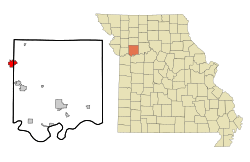
Location of Lawson, Missouri
|
|
| Country | United States |
| State | Missouri |
| Counties | Ray, Clinton, Clay |
| Area | |
| • Total | 3.05 sq mi (7.91 km2) |
| • Land | 2.96 sq mi (7.67 km2) |
| • Water | 0.09 sq mi (0.24 km2) |
| Elevation | 1,034 ft (315 m) |
| Population
(2020)
|
|
| • Total | 2,541 |
| • Density | 857.58/sq mi (331.12/km2) |
| Time zone | UTC-6 (Central (CST)) |
| • Summer (DST) | UTC-5 (CDT) |
| ZIP code |
64062
|
| Area code(s) | 816 |
| FIPS code | 29-40988 |
| GNIS feature ID | 2395650 |
| Website | https://lawsonmo.gov/ |
Lawson is a city in the state of Missouri, United States. It is located where three counties meet: Clay, Clinton, and Ray. Lawson is also part of the larger Kansas City metropolitan area. In 2020, the city had a population of 2,541 people.
Contents
History of Lawson
Lawson was founded, or started, in 1870. The city was named after L. M. Lawson, a businessman from New York. A post office, which is where you send and receive mail, has been operating in Lawson since 1876.
Lawson is home to the oldest bank in Ray County, called Lawson Bank. It was established in 1883. Near Lawson, you can visit interesting places like the historic Watkins Mill. This mill is now a Missouri state park and a very important historical site. Also nearby was KC-10L, a Nike missile base. This base was active from November 1959 to February 1964.
Geography and Land Area
According to the United States Census Bureau, the city of Lawson covers a total area of about 2.59 square miles (6.71 square kilometers). Most of this area, about 2.53 square miles (6.55 square kilometers), is land. The remaining part, about 0.06 square miles (0.16 square kilometers), is water.
Population and People
Lawson has grown quite a bit over the years. Here's how the population has changed:
| Historical population | |||
|---|---|---|---|
| Census | Pop. | %± | |
| 1880 | 223 | — | |
| 1890 | 520 | 133.2% | |
| 1900 | 635 | 22.1% | |
| 1910 | 604 | −4.9% | |
| 1920 | 545 | −9.8% | |
| 1930 | 590 | 8.3% | |
| 1940 | 511 | −13.4% | |
| 1950 | 486 | −4.9% | |
| 1960 | 778 | 60.1% | |
| 1970 | 1,034 | 32.9% | |
| 1980 | 1,743 | 68.6% | |
| 1990 | 1,876 | 7.6% | |
| 2000 | 2,336 | 24.5% | |
| 2010 | 2,473 | 5.9% | |
| 2020 | 2,541 | 2.7% | |
| U.S. Decennial Census | |||
Lawson's Population in 2010
In 2010, there were 2,473 people living in Lawson. These people lived in 876 households, and 676 of these were families. A household is a group of people living together in one home.
Many households, about 45.2%, had children under 18 years old living with them. Most households, 59.1%, were married couples living together. About 20.7% of all households were made up of just one person. Also, 10.4% of households had someone living alone who was 65 years old or older.
The average age of people in Lawson in 2010 was 33.1 years. About 31.2% of the residents were under 18 years old. Around 11.8% of the people were 65 years old or older. The city had slightly more females (51.5%) than males (48.5%).
Education in Lawson
Public schools in Lawson are managed by the Lawson R-XIV School District. This district runs one elementary school for younger students. It also has one middle school and Lawson High School for older students. Lawson also has a public library, which is called the Lawson Community Branch Library.
See also
 In Spanish: Lawson (Misuri) para niños
 | John T. Biggers |
 | Thomas Blackshear |
 | Mark Bradford |
 | Beverly Buchanan |

