Orrick, Missouri facts for kids
Quick facts for kids
Orrick, Missouri
|
|
|---|---|

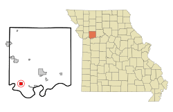
Location of Orrick, Missouri
|
|
| Country | United States |
| State | Missouri |
| County | Ray |
| Area | |
| • Total | 1.33 sq mi (3.46 km2) |
| • Land | 1.33 sq mi (3.46 km2) |
| • Water | 0.00 sq mi (0.00 km2) |
| Elevation | 722 ft (220 m) |
| Population
(2020)
|
|
| • Total | 753 |
| • Density | 564.04/sq mi (217.83/km2) |
| Time zone | UTC-6 (Central (CST)) |
| • Summer (DST) | UTC-5 (CDT) |
| ZIP code |
64077
|
| Area code(s) | 816 |
| FIPS code | 29-54938 |
| GNIS feature ID | 2396085 |
Orrick is a small town in Ray County, Missouri, located in the Kansas City metropolitan area in the United States. In 2020, the town had a population of 753 people.
Contents
History of Orrick
The first community in this area was called Albany. It was started by Ely Carter in 1854. When he tried to get a post office, his request was turned down. This was because another town named Albany already existed in Missouri.
So, he used his wife's name, Ada, for the post office. However, people still called the town Albany.
During the American Civil War, a famous person named "Bloody Bill" Anderson was killed near here. This happened during the Battle of Albany on October 24, 1864.
Albany officially became a town in 1871. But a few years earlier, a railroad line was built about a mile south of Albany. This new railroad, the St. Louis, Kansas City and Northern Star railroad (later known as the Wabash Railroad), was built in 1868 and 1869.
A new community quickly grew up around the railroad tracks. This new place was named Orrick. The railroad company planned out the town. It was named after W. W. Orrick, who helped create the town's map. Orrick officially became a town in 1873.
Tornadoes in Orrick
Orrick has experienced some powerful tornadoes. On January 24, 1967, an unusual winter tornado hit the town. It destroyed the local high school and sadly, two students lost their lives.
Later, on May 10, 2014, another strong tornado formed southwest of Orrick. As it moved towards the town, it grew stronger. The tornado reached EF2 intensity as it passed through Orrick.
Geography of Orrick
Orrick is located entirely on land. According to the United States Census Bureau, the town covers a total area of about 1.34 square miles (3.46 square kilometers).
Population of Orrick
| Historical population | |||
|---|---|---|---|
| Census | Pop. | %± | |
| 1880 | 193 | — | |
| 1890 | 370 | 91.7% | |
| 1900 | 391 | 5.7% | |
| 1910 | 435 | 11.3% | |
| 1920 | 632 | 45.3% | |
| 1930 | 689 | 9.0% | |
| 1940 | 666 | −3.3% | |
| 1950 | 675 | 1.4% | |
| 1960 | 800 | 18.5% | |
| 1970 | 883 | 10.4% | |
| 1980 | 922 | 4.4% | |
| 1990 | 935 | 1.4% | |
| 2000 | 889 | −4.9% | |
| 2010 | 837 | −5.8% | |
| 2020 | 753 | −10.0% | |
| U.S. Decennial Census | |||
The population of Orrick has changed over the years. You can see how many people lived there in different census years in the table above.
Orrick in 2010
In 2010, the census counted 837 people living in Orrick. There were 319 households, which are groups of people living together in one home. About 221 of these were families.
Most of the people in Orrick were White (97.7%). A small number were African American, Native American, or Asian. About 2.3% of the population identified as Hispanic or Latino.
Many households (41.7%) had children under 18 living with them. More than half (52.0%) were married couples. The average household had 2.62 people, and the average family had 3.20 people.
The median age in Orrick was 35.2 years old. This means half the people were younger than 35.2 and half were older. About 30.8% of residents were under 18. Also, 9.8% of the people were 65 years old or older.
Education in Orrick
Orrick is proud of its high school football team, the Orrick Bearcats. They have won several Missouri state high school football championships. Their championship wins were in 1975, 2007, and 2008.
See also
 In Spanish: Orrick (Misuri) para niños
 | Kyle Baker |
 | Joseph Yoakum |
 | Laura Wheeler Waring |
 | Henry Ossawa Tanner |

