
Smithville, Missouri facts for kids
Quick facts for kids
Smithville, Missouri
|
|
|---|---|
 |
|

Location of Smithville, Missouri
|
|
| Country | United States |
| State | Missouri |
| Counties | Clay, Platte |
| Area | |
| • Total | 16.26 sq mi (42.12 km2) |
| • Land | 16.16 sq mi (41.84 km2) |
| • Water | 0.11 sq mi (0.28 km2) |
| Elevation | 814 ft (248 m) |
| Population
(2020)
|
|
| • Total | 10,406 |
| • Density | 644.13/sq mi (248.71/km2) |
| Time zone | UTC-6 (Central (CST)) |
| • Summer (DST) | UTC-5 (CDT) |
| ZIP code |
64089
|
| Area code(s) | 816 |
| FIPS code | 29-68420 |
| GNIS feature ID | 2395903 |
Smithville is a city in Missouri, located in both Clay and Platte counties. It is part of the larger Kansas City metropolitan area. The city sits along the Little Platte River. In 2020, about 10,406 people lived there. Smithville is also well-known for the nearby Smithville Lake.
Contents
Exploring Smithville's Location and Landscape
Smithville is found in the western part of Clay County. The Little Platte River flows through the area. Just east of the city, the Little Platte River is dammed to create the Smithville Lake, a popular spot for outdoor activities. U.S. Route 169 runs along the west side of the city, making it easy to get around.
According to the United States Census Bureau, Smithville covers about 15.67 square miles (40.59 square kilometers). Most of this area is land, with a small part being water.
Smithville's Weather and Climate
Smithville has a humid subtropical climate, which means it has hot, humid summers and mild winters. This type of climate is often called "Cfa" on climate maps.
The hottest temperature ever recorded in Smithville was 107°F (42°C) on August 9, 1988. The coldest temperature recorded was -26°F (-32°C) on December 23, 1989, and again on February 16, 2021.
| Climate data for Smithville, Missouri (Smithville Lake), 1991–2020 normals, extremes 1985–present | |||||||||||||
|---|---|---|---|---|---|---|---|---|---|---|---|---|---|
| Month | Jan | Feb | Mar | Apr | May | Jun | Jul | Aug | Sep | Oct | Nov | Dec | Year |
| Record high °F (°C) | 72 (22) |
76 (24) |
86 (30) |
92 (33) |
93 (34) |
103 (39) |
104 (40) |
107 (42) |
104 (40) |
92 (33) |
80 (27) |
73 (23) |
107 (42) |
| Mean maximum °F (°C) | 60.8 (16.0) |
66.2 (19.0) |
76.6 (24.8) |
82.9 (28.3) |
87.7 (30.9) |
92.7 (33.7) |
97.1 (36.2) |
97.0 (36.1) |
92.0 (33.3) |
84.6 (29.2) |
69.4 (20.8) |
62.4 (16.9) |
98.7 (37.1) |
| Mean daily maximum °F (°C) | 36.3 (2.4) |
41.7 (5.4) |
52.6 (11.4) |
63.6 (17.6) |
72.8 (22.7) |
82.2 (27.9) |
86.5 (30.3) |
85.3 (29.6) |
77.8 (25.4) |
66.1 (18.9) |
53.3 (11.8) |
41.6 (5.3) |
63.3 (17.4) |
| Daily mean °F (°C) | 26.3 (−3.2) |
31.2 (−0.4) |
42.0 (5.6) |
52.4 (11.3) |
62.9 (17.2) |
72.7 (22.6) |
77.1 (25.1) |
75.5 (24.2) |
67.0 (19.4) |
54.8 (12.7) |
42.3 (5.7) |
31.8 (−0.1) |
53.0 (11.7) |
| Mean daily minimum °F (°C) | 16.3 (−8.7) |
20.7 (−6.3) |
31.3 (−0.4) |
41.2 (5.1) |
53.0 (11.7) |
63.2 (17.3) |
67.6 (19.8) |
65.7 (18.7) |
56.2 (13.4) |
43.5 (6.4) |
31.3 (−0.4) |
22.1 (−5.5) |
42.7 (5.9) |
| Mean minimum °F (°C) | −3.1 (−19.5) |
2.9 (−16.2) |
13.8 (−10.1) |
26.6 (−3.0) |
38.0 (3.3) |
50.8 (10.4) |
57.3 (14.1) |
55.6 (13.1) |
40.6 (4.8) |
26.9 (−2.8) |
16.5 (−8.6) |
4.5 (−15.3) |
−6.2 (−21.2) |
| Record low °F (°C) | −20 (−29) |
−26 (−32) |
−9 (−23) |
8 (−13) |
28 (−2) |
41 (5) |
47 (8) |
41 (5) |
29 (−2) |
14 (−10) |
−3 (−19) |
−26 (−32) |
−26 (−32) |
| Average precipitation inches (mm) | 1.15 (29) |
1.40 (36) |
2.29 (58) |
3.85 (98) |
5.38 (137) |
5.27 (134) |
4.87 (124) |
4.36 (111) |
4.30 (109) |
3.47 (88) |
2.10 (53) |
1.59 (40) |
40.03 (1,017) |
| Average snowfall inches (cm) | 2.6 (6.6) |
3.1 (7.9) |
0.8 (2.0) |
0.1 (0.25) |
0.0 (0.0) |
0.0 (0.0) |
0.0 (0.0) |
0.0 (0.0) |
0.0 (0.0) |
0.2 (0.51) |
0.4 (1.0) |
2.1 (5.3) |
9.3 (23.56) |
| Average extreme snow depth inches (cm) | 3.4 (8.6) |
3.6 (9.1) |
1.6 (4.1) |
0.1 (0.25) |
0.0 (0.0) |
0.0 (0.0) |
0.0 (0.0) |
0.0 (0.0) |
0.0 (0.0) |
0.0 (0.0) |
0.3 (0.76) |
2.3 (5.8) |
5.3 (13) |
| Average precipitation days (≥ 0.01 in) | 5.1 | 4.9 | 7.0 | 10.0 | 13.8 | 11.2 | 9.1 | 8.8 | 9.1 | 8.6 | 5.1 | 3.6 | 96.3 |
| Average snowy days (≥ 0.1 in) | 1.7 | 1.5 | 0.5 | 0.1 | 0.0 | 0.0 | 0.0 | 0.0 | 0.0 | 0.1 | 0.3 | 1.4 | 5.6 |
| Source 1: NOAA | |||||||||||||
| Source 2: National Weather Service | |||||||||||||
The History of Smithville
Smithville gets its name from Humphrey "Yankee" Smith. He settled in this area in 1822. The town was first called "Smith's Mill." Later, its name changed to "Smithville" because it was easier to say. Another story says the name was changed to avoid confusion with another place in Missouri already called Smith's Mill.
Did you know that famous actors Wallace Beery and Noah Beery, Sr. were born and grew up near Smithville? They were big stars in early Hollywood movies.
Two important historical sites in Smithville are listed on the National Register of Historic Places. These are the Aker Cemetery and the Downtown Smithville Historic District. These places help preserve the city's past.
Understanding Smithville's Population
The number of people living in Smithville has grown quite a bit over the years. Here's a look at how the population has changed:
| Historical population | |||
|---|---|---|---|
| Census | Pop. | %± | |
| 1880 | 231 | — | |
| 1890 | 372 | 61.0% | |
| 1900 | 427 | 14.8% | |
| 1910 | 680 | 59.3% | |
| 1920 | 782 | 15.0% | |
| 1930 | 902 | 15.3% | |
| 1940 | 772 | −14.4% | |
| 1950 | 947 | 22.7% | |
| 1960 | 1,254 | 32.4% | |
| 1970 | 1,785 | 42.3% | |
| 1980 | 1,873 | 4.9% | |
| 1990 | 2,525 | 34.8% | |
| 2000 | 5,514 | 118.4% | |
| 2010 | 8,425 | 52.8% | |
| 2020 | 10,406 | 23.5% | |
| U.S. Decennial Census | |||
Smithville's Population in 2020
The 2020 United States census counted 10,406 people in Smithville. There were 3,647 households and 2,864 families. The city had about 644 people per square mile. Most residents, about 90.77%, were white. Other groups included African American, Native American, Asian, and Pacific Islander people. About 6.4% of the population identified with two or more races. People of Hispanic or Latino background made up 0.9% of the population.
About 37.1% of households had children under 18 living there. Many households (59.3%) were married couples. The average household had 2.8 people. The average family had 3.1 people.
About 26.5% of the people were under 18 years old. The median age in the city was 36.5 years. This means half the people were younger than 36.5 and half were older.
The average income for households was about $83,400. For families, it was around $92,279. A small percentage of families (2.7%) and individuals (6.1%) lived below the poverty line. This included some children and older adults.
Smithville's Population in 2010
In the census of 2010, Smithville had 8,425 people. There were 3,115 households and 2,321 families. The city had about 541 people per square mile. Most of the people (96.0%) were White. Other groups included African American, Native American, and Asian people. About 2.6% of the population was Hispanic or Latino.
About 29% of residents were under 18 years old. The median age in the city was 36.9 years. The population was almost evenly split between males (49.0%) and females (51.0%).
Education in Smithville
The Smithville R-II School District manages the local schools. This includes three elementary schools, one middle school, and Smithville High School.
Smithville also has a public library. It is a branch of the Mid-Continent Public Library system. Libraries offer books, computers, and programs for everyone.
Notable People from Smithville
- Bradford Keeney – A well-known therapist.
- Jayce Tingler – A professional baseball coach for the Minnesota Twins.
- Kenneth Wilson – A person who served in the Missouri House of Representatives.
Images for kids
-
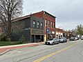
The Downtown Smithville Historic District.
See also
 In Spanish: Smithville (Misuri) para niños
